TopoQuest Logo
Do you find TopoQuest useful?
Help keep TopoQuest running and adding new maps/features by donating!
Bitcoin:  19c7KJd3qBynnjoSw5npx9KScwjBe4ifkT
Litecoin:  LXs6TkuXGGXo1vDsWCkWVdjQX94eUKd6ui
Home View Maps Find Maps Find Places Resources & Links


Little Axe, Oklahoma Topographic Map

USGS Map Title: Little Axe, OK
USGS Map MRC: 35097B2
DRG (GeoTIFF) Download: o35097b2.tif


Neighboring USGS Topographic Map Quads:


  Franklin, OK  
35097C3
 

  Stella, OK  
35097C2
 

  Shawnee Reservoir, OK  
35097C1
 

  Denver, OK  
35097B3
 

  Little Axe, OK  
35097B2
 

  Macomb, OK  
35097B1
 

  Purcell, OK  
35097A3
 

  Eason, OK  
35097A2
 

  Tribbey, OK  
35097A1


Map MRC Location:

N36°
W98°
N36°
W97°
H8 H7 H6 H5 H4 H3 H2 H1
G8 G7 G6 G5 G4 G3 G2 G1
F8 F7 F6 F5 F4 F3 F2 F1
E8 E7 E6 E5 E4 E3 E2 E1
D8 D7 D6 D5 D4 D3 D2 D1
C8 C7 C6 C5 C4 C3 C2 C1
B8 B7 B6 B5 B4 B3 B2 B1
A8 A7 A6 A5 A4 A3 A2 A1
N35°
W98°
N35°
W97°

Little Axe, OK USGS 1:24K Topographic Map Preview:
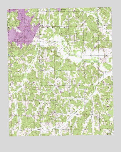
Little Axe, OK USGS Topographic Map
Click on map above to begin viewing in our Map Viewer.

This topographic map contains these locations and features:
Feature Name Type Latitude Longitude GNIS ID View Map
Bennett ChurchChurchN35.1892°W97.2117°1090006View Map
Bethel CemeteryCemeteryN35.1598°W97.1970°1090034View Map
Bourbonais CreekStreamN35.1659°W97.1492°1090421View Map
Cedar Country Fire Protection District North StationBuildingN35.1582°W97.1769°2658712View Map
East Cleveland DivisionCivilN35.1367°W97.2413°1937692View Map
EtowahPopulated PlaceN35.1270°W97.1689°1102936View Map
Etowah ChurchChurchN35.1456°W97.1625°1092640View Map
Hickory Hills AirportAirportN35.1662°W97.2234°1102587View Map
Hog CreekStreamN35.2267°W97.2245°1093823View Map
Lake ThunderbirdReservoirN35.2207°W97.2381°1100127View Map
Lake Thunderbird DamDamN35.2167°W97.2170°1751090View Map
Lakeside Free Will Baptist ChurchChurchN35.2176°W97.1606°1801325View Map
Little AxePopulated PlaceN35.2326°W97.2125°1100587View Map
Little Axe Elementary SchoolSchoolN35.2418°W97.1959°2712878View Map
Little Axe High SchoolSchoolN35.2339°W97.1949°2713021View Map
Little Axe Middle SchoolSchoolN35.2351°W97.1952°2712978View Map
Little Jim MissionChurchN35.2403°W97.2134°1094784View Map
Little River State ParkParkN35.2112°W97.2417°1094810View Map
Mars Hill CemeteryCemeteryN35.1603°W97.1256°1095150View Map
NeedmorePopulated PlaceN35.1312°W97.2122°1100665View Map
Norman Fire Department Station 5BuildingN35.2301°W97.1947°2658547View Map
Oknoname 12513 DamDamN35.1767°W97.1353°1754889View Map
Oknoname 12513 ReservoirReservoirN35.1766°W97.1363°1754890View Map
Prairie CreekStreamN35.2167°W97.1975°1096896View Map
Reynolds LakeReservoirN35.2493°W97.1882°1097182View Map
Reynolds Lake DamDamN35.2467°W97.1870°1753079View Map
Roulette CreekStreamN35.2040°W97.1728°1097483View Map
Spring CreekStreamN35.1865°W97.1364°1098417View Map
Town of EtowahCivilN35.1291°W97.1639°2412604View Map
Township of Little RiverCivilN35.2320°W97.1920°1824747View Map

Note: Coordinates in the location and feature list above are referenced to NAD83 datum.


Copyright (C) 2008-2024 Ryan Niemi / Sunset Dynamics ... All Rights Reserved