TopoQuest Logo
Do you find TopoQuest useful?
Help keep TopoQuest running and adding new maps/features by donating!
Bitcoin:  19c7KJd3qBynnjoSw5npx9KScwjBe4ifkT
Litecoin:  LXs6TkuXGGXo1vDsWCkWVdjQX94eUKd6ui
Home View Maps Find Maps Find Places Resources & Links


Dewey, Montana Topographic Map

USGS Map Title: Dewey, MT
USGS Map MRC: 45112G7
DRG (GeoTIFF) Download: o45112g7.tif


Neighboring USGS Topographic Map Quads:


  Dickie Peak, MT  
45112H8
 

  Burnt Mountain, MT  
45112H7
 

  Buxton, MT  
45112H6
 

  Wise River, MT  
45112G8
 

  Dewey, MT  
45112G7
 

  Tucker Creek, MT  
45112G6
 

  Vipond Park, MT  
45112F8
 

  Cattle Gulch, MT  
45112F7
 

  Melrose, MT  
45112F6


Map MRC Location:

N46°
W113°
N46°
W112°
H8 H7 H6 H5 H4 H3 H2 H1
G8 G7 G6 G5 G4 G3 G2 G1
F8 F7 F6 F5 F4 F3 F2 F1
E8 E7 E6 E5 E4 E3 E2 E1
D8 D7 D6 D5 D4 D3 D2 D1
C8 C7 C6 C5 C4 C3 C2 C1
B8 B7 B6 B5 B4 B3 B2 B1
A8 A7 A6 A5 A4 A3 A2 A1
N45°
W113°
N45°
W112°

Dewey, MT USGS 1:24K Topographic Map Preview:
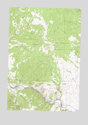
Dewey, MT USGS Topographic Map
Click on map above to begin viewing in our Map Viewer.

This topographic map contains these locations and features:
Feature Name Type Latitude Longitude GNIS ID View Map
Big Hole Copper MineMineN45.7785°W112.7767°805259View Map
Big Hole DamDamN45.7614°W112.8033°779818View Map
Big Hole Pumping StationLocaleN45.7646°W112.7873°799286View Map
Cayuga MineMineN45.7802°W112.7725°805260View Map
Charcoal CreekStreamN45.7638°W112.7861°781159View Map
Charcoal GulchValleyN45.7819°W112.7881°781161View Map
Charcoal MountainSummitN45.7830°W112.7789°781163View Map
DeweyPopulated PlaceN45.7771°W112.8550°782339View Map
Dewey CemeteryCemeteryN45.7705°W112.8628°782340View Map
Dewey Fishing Access SiteLocaleN45.7780°W112.8573°1744472View Map
Dewey Post Office (historical)Post OfficeN45.7771°W112.8550°1797230View Map
Dewey School (historical)SchoolN45.7769°W112.8553°1797330View Map
Divide Bridge CampgroundLocaleN45.7566°W112.7834°794507View Map
Divide Post OfficePost OfficeN45.7508°W112.7545°1797867View Map
Divide SchoolSchoolN45.7501°W112.7542°782414View Map
Fleecer RidgeRidgeN45.8710°W112.8320°783532View Map
Grafton MineMineN45.8263°W112.8245°805254View Map
Greenwood Bottoms Fishing Access SiteLocaleN45.7788°W112.8548°1744471View Map
Hogback RidgeRidgeN45.8649°W112.8445°784926View Map
Indian CreekStreamN45.8360°W112.8736°785243View Map
Jerry Creek Cow CampLocaleN45.8416°W112.8653°785467View Map
Leffler CreekStreamN45.7799°W112.8570°786025View Map
Limekiln GulchValleyN45.7730°W112.8628°778815View Map
Long Tom CreekStreamN45.8577°W112.8673°786543View Map
Mitchell ParkFlatN45.8108°W112.8459°787516View Map
Mount FleecerSummitN45.8263°W112.8025°783533View Map
NE NW Section 22 MineMineN45.8294°W112.8303°805252View Map
Nez Perce GulchValleyN45.7763°W112.8623°787981View Map
NW NW Section 9 MineMineN45.7705°W112.8545°802443View Map
NW SE Section 15 MineMineN45.8352°W112.8311°805255View Map
NW SW Section 9 MineMineN45.7646°W112.8536°802442View Map
Old Tom Horn MineMineN45.8146°W112.7884°805253View Map
Parker CreekStreamN45.8480°W112.8514°788651View Map
Powerhouse Fishing Access SiteLocaleN45.7777°W112.8348°1744473View Map
Quartz Hill GulchValleyN45.7724°W112.8625°789277View Map
Sawmill GulchValleyN45.7538°W112.7778°790076View Map
Sheep GulchValleyN45.7771°W112.8286°790343View Map
South Fork ReservoirReservoirN45.8572°W112.7503°791035View Map
Tub SpringSpringN45.8355°W112.8125°792427View Map

Note: Coordinates in the location and feature list above are referenced to NAD83 datum.


Copyright (C) 2008-2025 Ryan Niemi / Sunset Dynamics ... All Rights Reserved