TopoQuest Logo
Do you find TopoQuest useful?
Help keep TopoQuest running and adding new maps/features by donating!
Bitcoin:  19c7KJd3qBynnjoSw5npx9KScwjBe4ifkT
Litecoin:  LXs6TkuXGGXo1vDsWCkWVdjQX94eUKd6ui
Home View Maps Find Maps Find Places Resources & Links


Dieterich, Illinois Topographic Map

USGS Map Title: Dieterich, IL
USGS Map MRC: 39088A4
DRG (GeoTIFF) Download: o39088a4.tif


Neighboring USGS Topographic Map Quads:


  Effingham North, IL  
39088B5
 

  Teutopolis, IL  
39088B4
 

  Woodbury, IL  
39088B3
 

  Effingham South, IL  
39088A5
 

  Dieterich, IL  
39088A4
 

  Wheeler, IL  
39088A3
 

  Hord, IL  
38088H5
 

  Eberle, IL  
38088H4
 

  Latona, IL  
38088H3


Map MRC Location:

N40°
W89°
N40°
W88°
H8 H7 H6 H5 H4 H3 H2 H1
G8 G7 G6 G5 G4 G3 G2 G1
F8 F7 F6 F5 F4 F3 F2 F1
E8 E7 E6 E5 E4 E3 E2 E1
D8 D7 D6 D5 D4 D3 D2 D1
C8 C7 C6 C5 C4 C3 C2 C1
B8 B7 B6 B5 B4 B3 B2 B1
A8 A7 A6 A5 A4 A3 A2 A1
N39°
W89°
N39°
W88°

Dieterich, IL USGS 1:24K Topographic Map Preview:
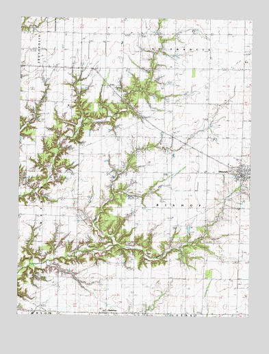
Dieterich, IL USGS Topographic Map
Click on map above to begin viewing in our Map Viewer.

This topographic map contains these locations and features:
Feature Name Type Latitude Longitude GNIS ID View Map
Bannick FarmLocaleN39.0003°W88.4172°2705561View Map
Beckman FarmsLocaleN39.0736°W88.4481°2705562View Map
Behrns FarmsLocaleN39.0858°W88.3817°2705563View Map
Bishop Creek Elementary SchoolSchoolN39.0614°W88.4370°404472View Map
DieterichPopulated PlaceN39.0620°W88.3798°407210View Map
Dieterich CemeteryCemeteryN39.0453°W88.3806°407211View Map
Dieterich CreekStreamN39.0295°W88.4484°407212View Map
Dieterich Elementary SchoolSchoolN39.0578°W88.3820°1810481View Map
Dieterich Fire Protection DistrictBuildingN39.0604°W88.3811°2682006View Map
Dieterich Junior-Senior High SchoolSchoolN39.0573°W88.3825°1810482View Map
Dieterich Post OfficePost OfficeN39.0591°W88.3802°1810483View Map
ElliottstownPopulated PlaceN39.0012°W88.4528°407896View Map
EversPopulated PlaceN39.0981°W88.4534°422681View Map
Goeckner FarmsLocaleN39.0481°W88.4233°2705560View Map
Hamland AcresLocaleN39.0317°W88.4194°2705566View Map
Hartke Swine CenterLocaleN39.1200°W88.4069°2705981View Map
King CemeteryCemeteryN39.0239°W88.4312°411486View Map
Maple Grove School (historical)SchoolN39.1114°W88.4442°412930View Map
Niemerg Dairy FarmLocaleN39.0672°W88.4164°2705567View Map
Probst Family FarmsLocaleN39.0717°W88.4656°2705325View Map
Rocky Ford Sportsman Club South Lake DamDamN39.0750°W88.3750°1692206View Map
Saint Aloysius CemeteryCemeteryN39.0623°W88.4400°1810532View Map
Saint John Lutheran CemeteryCemeteryN39.0153°W88.3853°1810539View Map
Saint Johns School (historical)SchoolN39.0159°W88.3842°417413View Map
Saint Paul Lutheran CemeteryCemeteryN39.1075°W88.3778°1810543View Map
Saint Pauls ChurchChurchN39.1073°W88.3784°417720View Map
Schottman FarmsLocaleN39.1206°W88.3778°2705559View Map
Township of BishopCivilN39.0454°W88.4148°428676View Map
Triple P FarmsLocaleN39.0589°W88.4697°2705327View Map
Veni Post Office (historical)Post OfficeN39.0439°W88.3992°1810552View Map
Village of DieterichCivilN39.0601°W88.3819°2398723View Map

Note: Coordinates in the location and feature list above are referenced to NAD83 datum.


Copyright (C) 2008-2025 Ryan Niemi / Sunset Dynamics ... All Rights Reserved