TopoQuest Logo
Do you find TopoQuest useful?
Help keep TopoQuest running and adding new maps/features by donating!
Bitcoin:  19c7KJd3qBynnjoSw5npx9KScwjBe4ifkT
Litecoin:  LXs6TkuXGGXo1vDsWCkWVdjQX94eUKd6ui
Home View Maps Find Maps Find Places Resources & Links


Teutopolis, Illinois Topographic Map

USGS Map Title: Teutopolis, IL
USGS Map MRC: 39088B4
DRG (GeoTIFF) Download: o39088b4.tif


Neighboring USGS Topographic Map Quads:


  Stewardson East, IL  
39088C5
 

  Neoga, IL  
39088C4
 

  Johnstown, IL  
39088C3
 

  Effingham North, IL  
39088B5
 

  Teutopolis, IL  
39088B4
 

  Woodbury, IL  
39088B3
 

  Effingham South, IL  
39088A5
 

  Dieterich, IL  
39088A4
 

  Wheeler, IL  
39088A3


Map MRC Location:

N40°
W89°
N40°
W88°
H8 H7 H6 H5 H4 H3 H2 H1
G8 G7 G6 G5 G4 G3 G2 G1
F8 F7 F6 F5 F4 F3 F2 F1
E8 E7 E6 E5 E4 E3 E2 E1
D8 D7 D6 D5 D4 D3 D2 D1
C8 C7 C6 C5 C4 C3 C2 C1
B8 B7 B6 B5 B4 B3 B2 B1
A8 A7 A6 A5 A4 A3 A2 A1
N39°
W89°
N39°
W88°

Teutopolis, IL USGS 1:24K Topographic Map Preview:
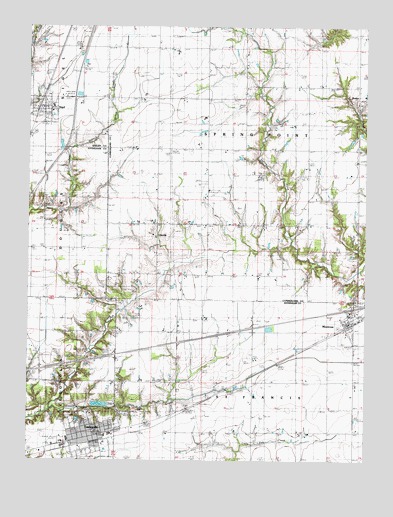
Teutopolis, IL USGS Topographic Map
Click on map above to begin viewing in our Map Viewer.

This topographic map contains these locations and features:
Feature Name Type Latitude Longitude GNIS ID View Map
Butterfly School (historical)SchoolN39.2292°W88.4528°405304View Map
Faunce CemeteryCemeteryN39.1784°W88.3967°408303View Map
First Salt CreekStreamN39.1400°W88.4912°408382View Map
Interchange 105CrossingN39.1692°W88.3792°1810510View Map
LillyvillePopulated PlaceN39.1898°W88.4520°422913View Map
Lillyville CemeteryCemeteryN39.1911°W88.4542°1820740View Map
Lillyville Elementary SchoolSchoolN39.1895°W88.4525°1808574View Map
Looman FarmsLocaleN39.1922°W88.4164°2705982View Map
MontrosePopulated PlaceN39.1653°W88.3792°413752View Map
Montrose CemeteryCemeteryN39.1711°W88.3784°413754View Map
Montrose Fire Protection DistrictBuildingN39.1647°W88.3810°2682574View Map
Montrose Post OfficePost OfficeN39.1644°W88.3816°1810524View Map
Needham CemeteryCemeteryN39.1839°W88.4062°414334View Map
Niemeyer FarmLocaleN39.1297°W88.4497°2705983View Map
Plain Tree School (historical)SchoolN39.1331°W88.4159°415750View Map
Pruemer FarmsLocaleN39.1275°W88.4433°2705980View Map
RoslynPopulated PlaceN39.2295°W88.3781°423133View Map
Roslyn United Methodist Church (historical)ChurchN39.2289°W88.3773°1820739View Map
Sacred Heart ChurchChurchN39.1900°W88.4539°1967357View Map
Saint Francis CemeteryCemeteryN39.1373°W88.4784°417282View Map
Saint Francis Town HallBuildingN39.1334°W88.4167°1725661View Map
Saint Michael Catholic ChurchChurchN39.2273°W88.4914°1967362View Map
Saint Michael Catholic SchoolSchoolN39.2270°W88.4912°1967363View Map
Saint Rose CemeteryCemeteryN39.1714°W88.3781°1820741View Map
Second Salt CreekStreamN39.1400°W88.4912°418175View Map
SigelPopulated PlaceN39.2262°W88.4942°418495View Map
Sigel Fire Protection DistrictBuildingN39.2261°W88.4951°2681822View Map
Sigel Post OfficePost OfficeN39.2270°W88.4934°2788298View Map
Spring Point School (historical)SchoolN39.2153°W88.4192°418984View Map
Spring Point Town HallBuildingN39.2223°W88.4100°1725682View Map
T and R Hog FarmLocaleN39.1578°W88.4983°2705328View Map
TeutopolisPopulated PlaceN39.1331°W88.4720°419609View Map
Teutopolis Fire Protection DistrictBuildingN39.1315°W88.4768°2681771View Map
Teutopolis Grade SchoolSchoolN39.1325°W88.4689°1810547View Map
Teutopolis High SchoolSchoolN39.1289°W88.4870°1810548View Map
Teutopolis Post OfficePost OfficeN39.1325°W88.4740°1810549View Map
Teutopolis Village HallBuildingN39.1325°W88.4744°2705979View Map
Town of SigelCivilN39.2257°W88.4945°2397663View Map
Township of Saint FrancisCivilN39.1304°W88.4141°429696View Map
Township of Spring PointCivilN39.2219°W88.3966°429790View Map
Township of TeutopolisCivilN39.1306°W88.4954°429830View Map
Village of MontroseCivilN39.1660°W88.3776°2399391View Map
Village of TeutopolisCivilN39.1314°W88.4819°2399962View Map

Note: Coordinates in the location and feature list above are referenced to NAD83 datum.


Copyright (C) 2008-2025 Ryan Niemi / Sunset Dynamics ... All Rights Reserved