TopoQuest Logo
Do you find TopoQuest useful?
Help keep TopoQuest running and adding new maps/features by donating!
Bitcoin:  19c7KJd3qBynnjoSw5npx9KScwjBe4ifkT
Litecoin:  LXs6TkuXGGXo1vDsWCkWVdjQX94eUKd6ui
Home View Maps Find Maps Find Places Resources & Links


Effingham South, Illinois Topographic Map

USGS Map Title: Effingham South, IL
USGS Map MRC: 39088A5
DRG (GeoTIFF) Download: o39088a5.tif


Neighboring USGS Topographic Map Quads:


  Shumway, IL  
39088B6
 

  Effingham North, IL  
39088B5
 

  Teutopolis, IL  
39088B4
 

  Altamont East, IL  
39088A6
 

  Effingham South, IL  
39088A5
 

  Dieterich, IL  
39088A4
 

  Edgewood, IL  
38088H6
 

  Hord, IL  
38088H5
 

  Eberle, IL  
38088H4


Map MRC Location:

N40°
W89°
N40°
W88°
H8 H7 H6 H5 H4 H3 H2 H1
G8 G7 G6 G5 G4 G3 G2 G1
F8 F7 F6 F5 F4 F3 F2 F1
E8 E7 E6 E5 E4 E3 E2 E1
D8 D7 D6 D5 D4 D3 D2 D1
C8 C7 C6 C5 C4 C3 C2 C1
B8 B7 B6 B5 B4 B3 B2 B1
A8 A7 A6 A5 A4 A3 A2 A1
N39°
W89°
N39°
W88°

Effingham South, IL USGS 1:24K Topographic Map Preview:
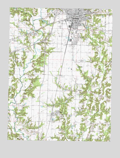
Effingham South, IL USGS Topographic Map
Click on map above to begin viewing in our Map Viewer.

This topographic map contains these locations and features:
Feature Name Type Latitude Longitude GNIS ID View Map
Air Evac LifeteamBuildingN39.0171°W88.5425°2674035View Map
Arch Air Medical ServicesBuildingN39.0799°W88.5442°2674045View Map
Big CreekStreamN39.0109°W88.6167°404387View Map
Bliss ParkParkN39.1142°W88.5445°1810472View Map
Blue Point CreekStreamN39.1134°W88.5951°404602View Map
Bourgeois FarmsLocaleN39.0897°W88.5711°2705282View Map
Brush CreekStreamN39.0689°W88.5092°405022View Map
Bryant School (historical)SchoolN39.0753°W88.5337°405074View Map
Central Grade SchoolSchoolN39.1198°W88.5437°1810478View Map
Central Illinois Public Service DamDamN39.1134°W88.5867°1691730View Map
Central Illinois Public Service ReservoirReservoirN39.1134°W88.5867°1691731View Map
Church of the NazareneChurchN39.1228°W88.5481°1810479View Map
Cips LakeReservoirN39.1123°W88.5823°1725654View Map
City of EffinghamCivilN39.1201°W88.5511°2394628View Map
D and V FarmsLocaleN39.0906°W88.5750°2705279View Map
East Side Grade SchoolSchoolN39.1234°W88.5389°1810484View Map
EffinghamPopulated PlaceN39.1200°W88.5434°407809View Map
Effingham City - County Ambulance ServiceBuildingN39.1225°W88.5462°2673961View Map
Effingham City HallBuildingN39.1203°W88.5450°1810489View Map
Effingham CountyCivilN39.0598°W88.5899°424226View Map
Effingham County CourthouseBuildingN39.1217°W88.5414°1810490View Map
Effingham County JailBuildingN39.1216°W88.5424°1810491View Map
Effingham County Memorial AirportAirportN39.0747°W88.5353°427246View Map
Effingham County Sheriff's OfficeBuildingN39.1217°W88.5426°2758863View Map
Effingham Fire Department Station 1BuildingN39.1196°W88.5485°2682343View Map
Effingham Fire Department Station 3BuildingN39.0990°W88.5478°2681928View Map
Effingham High SchoolSchoolN39.1175°W88.5556°1810492View Map
Effingham Police DepartmentBuildingN39.1207°W88.5403°2758865View Map
Effingham Post OfficePost OfficeN39.1229°W88.5406°1810493View Map
EwingtonPopulated PlaceN39.1017°W88.5973°1725656View Map
Ewington CemeteryCemeteryN39.0998°W88.5949°408135View Map
Ewington School (historical)SchoolN39.1050°W88.5981°408136View Map
Feldhake DairyLocaleN39.0769°W88.5350°2705283View Map
First Baptist ChurchChurchN39.1198°W88.5445°1810494View Map
First Christian ChurchChurchN39.1231°W88.5423°1810495View Map
First Presbyterian ChurchChurchN39.1203°W88.5492°1810496View Map
Free Methodist ChurchChurchN39.1212°W88.5495°1810498View Map
FunkhouserPopulated PlaceN39.0942°W88.6212°408817View Map
Funkhouser SchoolSchoolN39.0925°W88.6151°1810500View Map
Healthone ParamedicsBuildingN39.1219°W88.5513°2674039View Map
HeartvillePopulated PlaceN39.0506°W88.5434°1725657View Map
Helen Matthes LibraryBuildingN39.1234°W88.5417°1810504View Map
Hill School (historical)SchoolN39.0628°W88.5845°410265View Map
Illinois State Police District 12BuildingN39.0972°W88.5484°2759035View Map
Immanuel Lutheran CemeteryCemeteryN39.0623°W88.5617°1810508View Map
Interchange 157CrossingN39.0942°W88.5809°1810513View Map
Interchange 159CrossingN39.1206°W88.5517°1810514View Map
Interchange 160CrossingN39.1203°W88.5703°1964787View Map
Landfill 33LocaleN39.1019°W88.5258°2680788View Map
Lily CreekStreamN39.0600°W88.6095°412083View Map
Little Salt CreekStreamN39.0231°W88.5239°412408View Map
Little Wabash River DamDamN39.1050°W88.5917°1692406View Map
Little Wabash River ReservoirReservoirN39.1050°W88.5917°1692407View Map
Loy Chapel CemeteryCemeteryN39.0592°W88.5339°1810520View Map
Loy ChurchChurchN39.0598°W88.5337°412728View Map
Loy School (historical)SchoolN39.0470°W88.5378°412729View Map
Old Loy CemeteryCemeteryN39.0595°W88.5328°1810527View Map
Percival Springs AirportAirportN39.0154°W88.5393°427902View Map
Porter CemeteryCemeteryN39.0739°W88.6148°416044View Map
Rinehart CemeteryCemeteryN39.0900°W88.5475°416682View Map
Sacred Hearth SchoolSchoolN39.1189°W88.5459°1810531View Map
Saint Anthony Grade SchoolSchoolN39.1250°W88.5402°1810536View Map
Saint Anthony Memorial Hospital HeliportAirportN39.1245°W88.5503°427247View Map
Saint John Lutheran CemeteryCemeteryN39.1234°W88.5648°1810540View Map
Saint Johns ChurchChurchN39.0620°W88.5612°417388View Map
Saint Johns Lutheran ChurchChurchN39.1220°W88.5531°1810558View Map
Salt Creek ChurchChurchN39.0137°W88.5245°417896View Map
Salt Creek School (historical)SchoolN39.0164°W88.5331°417897View Map
South School (historical)SchoolN39.0917°W88.5620°418825View Map
South Side Grade SchoolSchoolN39.1115°W88.5443°1810546View Map
Toothaker CemeteryCemeteryN39.1214°W88.5926°419781View Map
Township of WatsonCivilN39.0463°W88.5228°429901View Map
Turner CemeteryCemeteryN39.0184°W88.6237°419948View Map
Village of WatsonCivilN39.0261°W88.5683°2400106View Map
WatsonPopulated PlaceN39.0253°W88.5698°420642View Map
Watson CemeteryCemeteryN39.0323°W88.5695°1810553View Map
Watson Fire Protection DistrictBuildingN39.0254°W88.5717°2682572View Map
Watson Post OfficePost OfficeN39.0251°W88.5712°1810554View Map
WCRA-AM (Effingham)TowerN39.1073°W88.5623°427990View Map
WCRC-FM (Effingham)TowerN39.1073°W88.5623°428191View Map
West Side Grade SchoolSchoolN39.1196°W88.5533°1810555View Map
White School (historical)SchoolN39.0256°W88.5964°421069View Map
Wood Lawn CemeteryCemeteryN39.1060°W88.5119°1810556View Map

Note: Coordinates in the location and feature list above are referenced to NAD83 datum.


Copyright (C) 2008-2024 Ryan Niemi / Sunset Dynamics ... All Rights Reserved