TopoQuest Logo
Do you find TopoQuest useful?
Help keep TopoQuest running and adding new maps/features by donating!
Bitcoin:  19c7KJd3qBynnjoSw5npx9KScwjBe4ifkT
Litecoin:  LXs6TkuXGGXo1vDsWCkWVdjQX94eUKd6ui
Home View Maps Find Maps Find Places Resources & Links


Dog Lake, Oregon Topographic Map

USGS Map Title: Dog Lake, OR
USGS Map MRC: 42120A6
DRG (GeoTIFF) Download: o42120a6.tif


Neighboring USGS Topographic Map Quads:


  Arkansas Flat, OR  
42120B7
 

  Drews Reservoir, OR  
42120B6
 

  Drews Gap, OR  
42120B5
 

  Strawberry Butte, OR  
42120A7
 

  Dog Lake, OR  
42120A6
 

  Fitzwater Point, OR  
42120A5
 

  Weed Valley, CA  
41120H7
 

  Beaver Mountain, CA  
41120H6
 

  Pease Flat, CA  
41120H5


Map MRC Location:

N43°
W121°
N43°
W120°
H8 H7 H6 H5 H4 H3 H2 H1
G8 G7 G6 G5 G4 G3 G2 G1
F8 F7 F6 F5 F4 F3 F2 F1
E8 E7 E6 E5 E4 E3 E2 E1
D8 D7 D6 D5 D4 D3 D2 D1
C8 C7 C6 C5 C4 C3 C2 C1
B8 B7 B6 B5 B4 B3 B2 B1
A8 A7 A6 A5 A4 A3 A2 A1
N42°
W121°
N42°
W120°

Dog Lake, OR USGS 1:24K Topographic Map Preview:
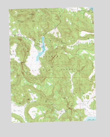
Dog Lake, OR USGS Topographic Map
Click on map above to begin viewing in our Map Viewer.

This topographic map contains these locations and features:
Feature Name Type Latitude Longitude GNIS ID View Map
Adams SpringSpringN42.1232°W120.7115°1137021View Map
Big Dog SpringSpringN42.1235°W120.7339°1138016View Map
Buckaroo PassGapN42.0602°W120.6922°1138839View Map
Campground Number One (historical)ParkN42.0827°W120.7069°1139291View Map
Campground Number Two (historical)ParkN42.0852°W120.7072°1139292View Map
Castle RockSummitN42.0254°W120.7266°1139447View Map
Cold SpringSpringN42.0221°W120.6979°1139921View Map
Dog LakeLakeN42.0744°W120.7056°1141135View Map
Dog Lake Burn SpringSpringN42.0909°W120.7322°1141136View Map
Dog Lake Campground Boat RampLocaleN42.0843°W120.7046°2700276View Map
Dog Lake Guard StationLocaleN42.0849°W120.7052°1160987View Map
Dog Lake Recreation SiteLocaleN42.0829°W120.7055°1155833View Map
Dog Lake SpringSpringN42.0804°W120.6825°1153758View Map
Dog Lake Work CenterLocaleN42.0840°W120.7102°1141137View Map
Dog MountainSummitN42.1185°W120.7189°1141138View Map
Dog Mountain CreekStreamN42.0768°W120.7102°1141140View Map
Fall CreekStreamN42.0149°W120.6466°1141961View Map
Fall ValleyValleyN42.0107°W120.6741°1142001View Map
Fred RossLocaleN42.0924°W120.7033°1155832View Map
Green CreekStreamN42.0615°W120.7200°1143027View Map
Green ValleyValleyN42.0663°W120.7350°1143059View Map
Horseshoe CreekStreamN42.1004°W120.6897°1143805View Map
Hunter SpringSpringN42.0956°W120.7445°1143937View Map
Jerry SpringSpringN42.0527°W120.7213°1144262View Map
Kitty SpringSpringN42.0903°W120.7154°1144651View Map
Little Dog SpringSpringN42.1114°W120.7384°1145152View Map
Little LakesLakeN42.0904°W120.6928°1145197View Map
McCoin CreekStreamN42.0135°W120.6439°1145938View Map
Mine SpringSpringN42.0304°W120.6452°1146307View Map
Navy SpringSpringN42.0902°W120.6332°1146738View Map
Nick Barry SpringSpringN42.1105°W120.7339°1146828View Map
Ross RanchLocaleN42.0624°W120.7269°1148740View Map
Scotts Cabin CreekStreamN42.1243°W120.6336°1149177View Map
Scotts Cabin SpringSpringN42.1201°W120.6359°1149178View Map
Slash SpringSpringN42.0211°W120.7397°1149658View Map
South Arm Yokum ValleyValleyN42.0079°W120.7366°1149900View Map
Telephone SpringSpringN42.1113°W120.7131°1150950View Map
Upper Road SpringSpringN42.0256°W120.6703°1151700View Map
White SpringSpringN42.0955°W120.7371°1152253View Map
Young ValleyValleyN42.0224°W120.7214°1152755View Map

Note: Coordinates in the location and feature list above are referenced to NAD83 datum.


Copyright (C) 2008-2025 Ryan Niemi / Sunset Dynamics ... All Rights Reserved