TopoQuest Logo
Do you find TopoQuest useful?
Help keep TopoQuest running and adding new maps/features by donating!
Bitcoin:  19c7KJd3qBynnjoSw5npx9KScwjBe4ifkT
Litecoin:  LXs6TkuXGGXo1vDsWCkWVdjQX94eUKd6ui
Home View Maps Find Maps Find Places Resources & Links


Drews Reservoir, Oregon Topographic Map

USGS Map Title: Drews Reservoir, OR
USGS Map MRC: 42120B6
DRG (GeoTIFF) Download: o42120b6.tif


Neighboring USGS Topographic Map Quads:


  Quartz Valley, OR  
42120C7
 

  Cougar Peak, OR  
42120C6
 

  Cox Flat, OR  
42120C5
 

  Arkansas Flat, OR  
42120B7
 

  Drews Reservoir, OR  
42120B6
 

  Drews Gap, OR  
42120B5
 

  Strawberry Butte, OR  
42120A7
 

  Dog Lake, OR  
42120A6
 

  Fitzwater Point, OR  
42120A5


Map MRC Location:

N43°
W121°
N43°
W120°
H8 H7 H6 H5 H4 H3 H2 H1
G8 G7 G6 G5 G4 G3 G2 G1
F8 F7 F6 F5 F4 F3 F2 F1
E8 E7 E6 E5 E4 E3 E2 E1
D8 D7 D6 D5 D4 D3 D2 D1
C8 C7 C6 C5 C4 C3 C2 C1
B8 B7 B6 B5 B4 B3 B2 B1
A8 A7 A6 A5 A4 A3 A2 A1
N42°
W121°
N42°
W120°

Drews Reservoir, OR USGS 1:24K Topographic Map Preview:
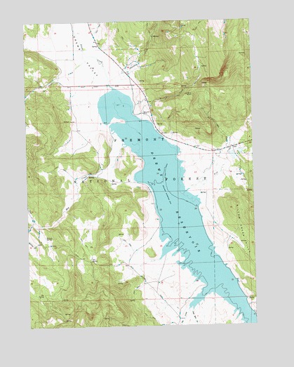
Drews Reservoir, OR USGS Topographic Map
Click on map above to begin viewing in our Map Viewer.

This topographic map contains these locations and features:
Feature Name Type Latitude Longitude GNIS ID View Map
Builta RanchLocaleN42.2274°W120.7336°1638706View Map
Chandler CreekStreamN42.2238°W120.7039°1139563View Map
D A Tracy RanchLocaleN42.1957°W120.6439°1638707View Map
Deely Twomey RanchLocaleN42.2293°W120.6961°1638705View Map
Dent CreekStreamN42.2349°W120.7102°1140900View Map
Dip SpringSpringN42.1375°W120.7433°1141043View Map
Dog CreekStreamN42.1313°W120.6633°1141130View Map
Drews ReservoirReservoirN42.1737°W120.6689°1141243View Map
Drews ValleyValleyN42.2254°W120.7072°1141244View Map
Drews Valley (historical)Populated PlaceN42.2277°W120.6927°1153763View Map
Drews Valley Post Office (historical)Post OfficeN42.2277°W120.6927°1165179View Map
Fish CreekStreamN42.1832°W120.6558°1142148View Map
Hay CreekStreamN42.1993°W120.6961°1143392View Map
Hay Creek RanchLocaleN42.2121°W120.6858°1143395View Map
Kerman SpringSpringN42.1616°W120.7412°1144570View Map
La Sere CreekStreamN42.1799°W120.6625°1144727View Map
La Sere PointSummitN42.2193°W120.6583°1144728View Map
Sagehen CreekStreamN42.1313°W120.6605°1148944View Map
Salt SpringSpringN42.1518°W120.7166°1149005View Map
Seventy CreekStreamN42.2093°W120.6861°1149265View Map
Stevenson CreekStreamN42.2388°W120.7191°1153762View Map
Upset CreekStreamN42.1674°W120.7469°1151712View Map
Vistillas (historical)Populated PlaceN42.1665°W120.7483°1158695View Map
Vistillas Post Office (historical)Post OfficeN42.1665°W120.7483°1166109View Map

Note: Coordinates in the location and feature list above are referenced to NAD83 datum.


Copyright (C) 2008-2025 Ryan Niemi / Sunset Dynamics ... All Rights Reserved