TopoQuest Logo
Do you find TopoQuest useful?
Help keep TopoQuest running and adding new maps/features by donating!
Bitcoin:  19c7KJd3qBynnjoSw5npx9KScwjBe4ifkT
Litecoin:  LXs6TkuXGGXo1vDsWCkWVdjQX94eUKd6ui
Home View Maps Find Maps Find Places Resources & Links


Dover, Oklahoma Topographic Map

USGS Map Title: Dover, OK
USGS Map MRC: 35097H8
DRG (GeoTIFF) Download: o35097h8.tif


Neighboring USGS Topographic Map Quads:


  Lacey, OK  
36098A1
 

  Hennessey, OK  
36097A8
 

  Union, OK  
36097A7
 

  Loyal, OK  
35098H1
 

  Dover, OK  
35097H8
 

  Kingfisher NE, OK  
35097H7
 

  Loyal SE, OK  
35098G1
 

  Kingfisher, OK  
35097G8
 

  Kingfisher SE, OK  
35097G7


Map MRC Location:

N36°
W98°
N36°
W97°
H8 H7 H6 H5 H4 H3 H2 H1
G8 G7 G6 G5 G4 G3 G2 G1
F8 F7 F6 F5 F4 F3 F2 F1
E8 E7 E6 E5 E4 E3 E2 E1
D8 D7 D6 D5 D4 D3 D2 D1
C8 C7 C6 C5 C4 C3 C2 C1
B8 B7 B6 B5 B4 B3 B2 B1
A8 A7 A6 A5 A4 A3 A2 A1
N35°
W98°
N35°
W97°

Dover, OK USGS 1:24K Topographic Map Preview:
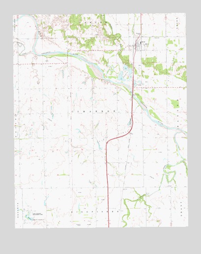
Dover, OK USGS Topographic Map
Click on map above to begin viewing in our Map Viewer.

This topographic map contains these locations and features:
Feature Name Type Latitude Longitude GNIS ID View Map
Boecher BridgeBridgeN35.9523°W97.9139°1090325View Map
Cooper CreekStreamN35.9787°W97.9862°1091671View Map
DoverPopulated PlaceN35.9814°W97.9112°1092173View Map
Dover CemeteryCemeteryN35.9856°W97.8988°1092174View Map
Dover Elementary SchoolSchoolN35.9837°W97.9081°1790625View Map
Dover High SchoolSchoolN35.9829°W97.9081°1803955View Map
Dover Police DepartmentBuildingN35.9844°W97.9091°2757421View Map
Dover Volunteer Fire DepartmentBuildingN35.9813°W97.9107°2658336View Map
Elmer Lake DamDamN35.8800°W97.9870°1750853View Map
Kingfisher CountyCivilN35.9454°W97.9421°1101824View Map
Kingfisher CreekStreamN35.9306°W97.8781°1094392View Map
Lake ElmerReservoirN35.8817°W97.9903°1092596View Map
Lou Anna CreekStreamN35.8862°W97.9217°1763652View Map
Oknoname 07308 DamDamN35.8884°W97.9787°1751134View Map
Oknoname 07308 ReservoirReservoirN35.8890°W97.9781°1751135View Map
Oknoname 07312 DamDamN35.9300°W97.9453°1752805View Map
Oknoname 07312 ReservoirReservoirN35.9295°W97.9480°1752806View Map
Oknoname 083028 DamDamN35.8750°W97.9003°1752699View Map
Oknoname 083028 ReservoirReservoirN35.8750°W97.9003°1752700View Map
Town of DoverCivilN35.9814°W97.9108°2412447View Map
Township of CimarronCivilN35.9417°W97.9531°1825568View Map
Trail CreekStreamN35.9137°W97.8789°1098963View Map
Treaty CreekStreamN35.9767°W97.9845°1101248View Map
Turkey CreekStreamN35.9606°W97.9289°1099049View Map
White AirportAirportN35.8870°W97.9589°1102526View Map

Note: Coordinates in the location and feature list above are referenced to NAD83 datum.


Copyright (C) 2008-2025 Ryan Niemi / Sunset Dynamics ... All Rights Reserved