TopoQuest Logo
Do you find TopoQuest useful?
Help keep TopoQuest running and adding new maps/features by donating!
Bitcoin:  19c7KJd3qBynnjoSw5npx9KScwjBe4ifkT
Litecoin:  LXs6TkuXGGXo1vDsWCkWVdjQX94eUKd6ui
Home View Maps Find Maps Find Places Resources & Links


Downs Mountain, Wyoming Topographic Map

USGS Map Title: Downs Mountain, WY
USGS Map MRC: 43109C6
DRG (GeoTIFF) Download: o43109c6.tif


Neighboring USGS Topographic Map Quads:


  Union Peak, WY  
43109D7
 

  Simpson Lake, WY  
43109D6
 

  Torrey Lake, WY  
43109D5
 

  Green River Lakes, WY  
43109C7
 

  Downs Mountain, WY  
43109C6
 

  Ink Wells, WY  
43109C5
 

  Squaretop Mountain, WY  
43109B7
 

  Gannett Peak, WY  
43109B6
 

  Fremont Peak North, WY  
43109B5


Map MRC Location:

N44°
W110°
N44°
W109°
H8 H7 H6 H5 H4 H3 H2 H1
G8 G7 G6 G5 G4 G3 G2 G1
F8 F7 F6 F5 F4 F3 F2 F1
E8 E7 E6 E5 E4 E3 E2 E1
D8 D7 D6 D5 D4 D3 D2 D1
C8 C7 C6 C5 C4 C3 C2 C1
B8 B7 B6 B5 B4 B3 B2 B1
A8 A7 A6 A5 A4 A3 A2 A1
N43°
W110°
N43°
W109°

Downs Mountain, WY USGS 1:24K Topographic Map Preview:
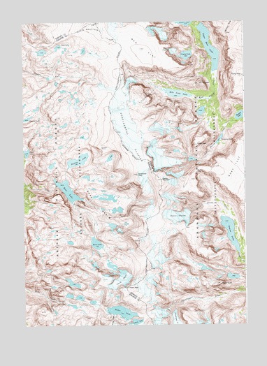
Downs Mountain, WY USGS Topographic Map
Click on map above to begin viewing in our Map Viewer.

This topographic map contains these locations and features:
Feature Name Type Latitude Longitude GNIS ID View Map
Baker LakeLakeN43.2555°W109.6954°1585063View Map
Bear BasinBasinN43.2997°W109.7077°1585237View Map
Bear LakeLakeN43.3057°W109.7253°1585265View Map
Bears ToothSummitN43.2669°W109.6365°1605111View Map
Bomber LakeLakeN43.3364°W109.6269°1598288View Map
Clear Creek MineMineN43.3083°W109.7049°1726299View Map
Connie GlacierGlacierN43.2686°W109.6935°1586933View Map
Continental GlacierGlacierN43.3341°W109.6915°1586939View Map
Crescent LakeLakeN43.3353°W109.7484°1599019View Map
Crystal LakeLakeN43.3613°W109.6576°1587275View Map
Dads LakeLakeN43.3650°W109.7298°1587325View Map
Daphne LakeLakeN43.3180°W109.7191°1587350View Map
Downs GlacierGlacierN43.2948°W109.6635°1587761View Map
Downs LakeLakeN43.2888°W109.6339°1587762View Map
Downs MountainSummitN43.3100°W109.6724°1587763View Map
Faler LakeLakeN43.3213°W109.7482°1588374View Map
Hunters HumpSummitN43.3233°W109.7052°1589820View Map
Iceberg LakeLakeN43.2509°W109.6884°1600479View Map
Kevin LakeLakeN43.2837°W109.7093°1590338View Map
Mile Long LakeLakeN43.3454°W109.6627°1591574View Map
No Mans PassGapN43.3133°W109.6507°1592070View Map
Northwest PeakSummitN43.3122°W109.6840°1592307View Map
Ram FlatFlatN43.3636°W109.6799°1593146View Map
Shale MountainSummitN43.3747°W109.7077°1602815View Map
Spider PeakSummitN43.3244°W109.6513°1594784View Map
The GuardianSummitN43.3497°W109.6496°1595425View Map
Torrey PeakSummitN43.3527°W109.6252°1595641View Map
Turquoise LakeLakeN43.3265°W109.6392°1595744View Map
Upper Ross LakeLakeN43.3646°W109.6444°1595880View Map
Yukon PeakSummitN43.2655°W109.6902°1596693View Map

Note: Coordinates in the location and feature list above are referenced to NAD83 datum.


Copyright (C) 2008-2025 Ryan Niemi / Sunset Dynamics ... All Rights Reserved