TopoQuest Logo
Do you find TopoQuest useful?
Help keep TopoQuest running and adding new maps/features by donating!
Bitcoin:  19c7KJd3qBynnjoSw5npx9KScwjBe4ifkT
Litecoin:  LXs6TkuXGGXo1vDsWCkWVdjQX94eUKd6ui
Home View Maps Find Maps Find Places Resources & Links


Doyline, Louisiana Topographic Map

USGS Map Title: Doyline, LA
USGS Map MRC: 32093E4
DRG (GeoTIFF) Download: o32093e4.tif


Neighboring USGS Topographic Map Quads:


  Bodcau Lake, LA  
32093F5
 

  Hortman, LA  
32093F4
 

  Minden North, LA  
32093F3
 

  Eastwood, LA  
32093E5
 

  Doyline, LA  
32093E4
 

  Minden South, LA  
32093E3
 

  Sligo, LA  
32093D5
 

  Koran, LA  
32093D4
 

  Heflin, LA  
32093D3


Map MRC Location:

N33°
W94°
N33°
W93°
H8 H7 H6 H5 H4 H3 H2 H1
G8 G7 G6 G5 G4 G3 G2 G1
F8 F7 F6 F5 F4 F3 F2 F1
E8 E7 E6 E5 E4 E3 E2 E1
D8 D7 D6 D5 D4 D3 D2 D1
C8 C7 C6 C5 C4 C3 C2 C1
B8 B7 B6 B5 B4 B3 B2 B1
A8 A7 A6 A5 A4 A3 A2 A1
N32°
W94°
N32°
W93°

Doyline, LA USGS 1:24K Topographic Map Preview:
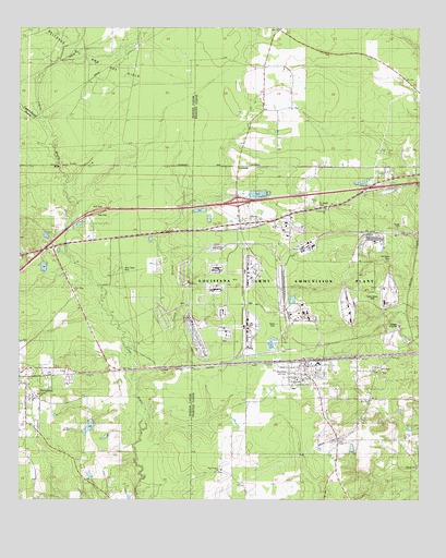
Doyline, LA USGS Topographic Map
Click on map above to begin viewing in our Map Viewer.

This topographic map contains these locations and features:
Feature Name Type Latitude Longitude GNIS ID View Map
Allen Town CemeteryCemeteryN32.5611°W93.4673°540953View Map
Caney BranchStreamN32.5318°W93.4627°533734View Map
Concord SchoolSchoolN32.5793°W93.4071°534078View Map
Crowe CemeteryCemeteryN32.5730°W93.3810°534291View Map
DoylinePopulated PlaceN32.5357°W93.4110°534581View Map
Doyline High SchoolSchoolN32.5361°W93.4062°544519View Map
Doyline Police DepartmentBuildingN32.5361°W93.4106°2755262View Map
Doyline Post OfficePost OfficeN32.5303°W93.4086°1631190View Map
Emanuel ChurchChurchN32.5740°W93.4279°540955View Map
Galilee ChurchChurchN32.5279°W93.4941°540951View Map
GoodwillPopulated PlaceN32.5888°W93.4327°541100View Map
Interchange 38CrossingN32.5788°W93.4321°541472View Map
Jenkins SchoolSchoolN32.5268°W93.3913°536022View Map
Jim Davis CemeteryCemeteryN32.5652°W93.3844°536045View Map
Kirk ChapelChurchN32.5349°W93.3882°536215View Map
LesliePopulated PlaceN32.5888°W93.4832°543396View Map
Louisiana Army Ammunition PlantMilitaryN32.5585°W93.3983°2512425View Map
New Hope ChurchChurchN32.5560°W93.4835°537583View Map
New Zion ChurchChurchN32.5265°W93.3907°540958View Map
Pigeon Roost BayouStreamN32.6010°W93.4946°538133View Map
Pilgrim Rest Baptist ChurchChurchN32.5082°W93.4371°555647View Map
Point ChapelChurchN32.5163°W93.4002°540956View Map
Raine CemeteryCemeteryN32.5465°W93.4202°540954View Map
Saint James CemeteryCemeteryN32.5779°W93.4071°540959View Map
Saint James Church (historical)ChurchN32.5788°W93.4088°544520View Map
Saint Matthew ChurchChurchN32.5768°W93.4049°538998View Map
Union Elementary SchoolSchoolN32.5297°W93.4142°544518View Map
United ChurchChurchN32.5343°W93.4857°540952View Map
Vanorsdale CemeteryCemeteryN32.5532°W93.3899°540138View Map
Village of DoylineCivilN32.5250°W93.4118°2407443View Map

Note: Coordinates in the location and feature list above are referenced to NAD83 datum.


Copyright (C) 2008-2025 Ryan Niemi / Sunset Dynamics ... All Rights Reserved