TopoQuest Logo
Do you find TopoQuest useful?
Help keep TopoQuest running and adding new maps/features by donating!
Bitcoin:  19c7KJd3qBynnjoSw5npx9KScwjBe4ifkT
Litecoin:  LXs6TkuXGGXo1vDsWCkWVdjQX94eUKd6ui
Home View Maps Find Maps Find Places Resources & Links


Minden North, Louisiana Topographic Map

USGS Map Title: Minden North, LA
USGS Map MRC: 32093F3
DRG (GeoTIFF) Download: o32093f3.tif


Neighboring USGS Topographic Map Quads:


  Cotton Valley, LA  
32093G4
 

  Leton, LA  
32093G3
 

  Blackburn, LA  
32093G2
 

  Hortman, LA  
32093F4
 

  Minden North, LA  
32093F3
 

  Langston, LA  
32093F2
 

  Doyline, LA  
32093E4
 

  Minden South, LA  
32093E3
 

  Ada, LA  
32093E2


Map MRC Location:

N33°
W94°
N33°
W93°
H8 H7 H6 H5 H4 H3 H2 H1
G8 G7 G6 G5 G4 G3 G2 G1
F8 F7 F6 F5 F4 F3 F2 F1
E8 E7 E6 E5 E4 E3 E2 E1
D8 D7 D6 D5 D4 D3 D2 D1
C8 C7 C6 C5 C4 C3 C2 C1
B8 B7 B6 B5 B4 B3 B2 B1
A8 A7 A6 A5 A4 A3 A2 A1
N32°
W94°
N32°
W93°

Minden North, LA USGS 1:24K Topographic Map Preview:
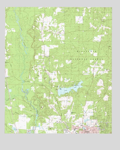
Minden North, LA USGS Topographic Map
Click on map above to begin viewing in our Map Viewer.

This topographic map contains these locations and features:
Feature Name Type Latitude Longitude GNIS ID View Map
Allen CemeteryCemeteryN32.6310°W93.3218°546965View Map
Blue Run ChurchChurchN32.7490°W93.2910°540794View Map
Blue Run SchoolSchoolN32.7490°W93.2932°547108View Map
Brushy CreekStreamN32.6463°W93.3360°547138View Map
Camp YatasiLocaleN32.6649°W93.3027°544501View Map
Caney CreekStreamN32.6654°W93.3524°547189View Map
Caney Creek Recreation AreaLocaleN32.6707°W93.2938°548274View Map
Caney LakesReservoirN32.6674°W93.3057°553886View Map
Caney Lakes Recreation SiteLocaleN32.6740°W93.2985°1630043View Map
Cow CreekStreamN32.6774°W93.3349°1629930View Map
DorcheatPopulated PlaceN32.6765°W93.3524°554259View Map
E S Richardson Elementary SchoolSchoolN32.6290°W93.2809°544512View Map
Fair Park Recreation CenterParkN32.6265°W93.2960°544508View Map
Garden of Memory CemeteryCemeteryN32.6385°W93.2854°544507View Map
Germantown Lookout TowerTowerN32.7099°W93.2974°1630045View Map
Gethsemane Family ChurchChurchN32.6276°W93.2843°544510View Map
GilarkPopulated PlaceN32.6388°W93.3096°547394View Map
Glenbrook SchoolSchoolN32.6415°W93.2946°544499View Map
GrimPopulated PlaceN32.7026°W93.3732°547422View Map
GrovePopulated PlaceN32.7376°W93.3313°547423View Map
Hinton Memorial ParkParkN32.6313°W93.2635°556565View Map
J E Harper Elementary SchoolSchoolN32.6347°W93.2688°1629817View Map
Johnsons Store (historical)LocaleN32.7357°W93.3302°544506View Map
KASO-AM (Minden)TowerN32.6307°W93.2824°1632546View Map
KASO-FM (Minden)TowerN32.6307°W93.2824°1632468View Map
Lakeview United Methodist ChurchChurchN32.6315°W93.2838°544511View Map
Long SpringsPopulated PlaceN32.6740°W93.3366°547626View Map
Long Springs ChurchChurchN32.6868°W93.3274°540793View Map
Long Springs SchoolSchoolN32.6826°W93.3232°547627View Map
Louisiana Technical College Northwest CampusSchoolN32.6288°W93.2932°540792View Map
Lower Caney DamDamN32.6668°W93.3168°556799View Map
Lower Caney LakeReservoirN32.6668°W93.3168°556800View Map
Martins Store (historical)LocaleN32.6999°W93.3154°544504View Map
Miller ChapelChurchN32.6874°W93.2552°540796View Map
Mims School (historical)SchoolN32.7168°W93.3313°544505View Map
Minden AirportAirportN32.6414°W93.3002°1632849View Map
Minden Fire Department Station 3BuildingN32.6318°W93.2728°2673025View Map
Minden Tennis and Aquatic CenterParkN32.6335°W93.2663°544513View Map
Mount Comfort ChurchChurchN32.7013°W93.3249°547746View Map
Mount Pilgrim ChurchChurchN32.6360°W93.3149°547755View Map
New Hope ChurchChurchN32.6949°W93.2707°540795View Map
New Hope SchoolSchoolN32.6921°W93.2691°547769View Map
Newsom CemeteryCemeteryN32.7118°W93.2504°556460View Map
Oak Grove School (historical)SchoolN32.6621°W93.3032°544500View Map
PacePopulated PlaceN32.6654°W93.3221°544502View Map
Parish Governing Authority District 6CivilN32.6409°W93.2626°1930165View Map
Parish Governing Authority District 8CivilN32.6257°W93.2839°1930256View Map
Pine Grove Methodist ChurchChurchN32.7371°W93.2616°555656View Map
Pine Hills Country ClubLocaleN32.6268°W93.2624°540797View Map
R D Hinton Pond DamDamN32.6385°W93.2818°556991View Map
Sausman CreekStreamN32.6365°W93.3396°547973View Map
Shady Grove CemeteryCemeteryN32.7263°W93.3102°547985View Map
Shady Grove Church (historical)ChurchN32.7015°W93.3293°544503View Map
Sugarcane TrailTrailN32.6749°W93.2904°1630059View Map
Sulphur SpringsSpringN32.7404°W93.2874°544514View Map
Upper Caney CampgroundLocaleN32.6749°W93.2910°559746View Map
Upper Caney DamDamN32.6718°W93.2835°556801View Map
Upper Caney LakeReservoirN32.6718°W93.2899°556802View Map
Valley Springs ChurchChurchN32.6271°W93.3668°540789View Map
Valley Springs SchoolSchoolN32.6268°W93.3668°548116View Map
Walker CemeteryCemeteryN32.6824°W93.3371°540791View Map
Webster ParishCivilN32.7135°W93.3350°559567View Map
Webster Parish Achievement Center SchoolSchoolN32.6255°W93.2915°544509View Map
Webster Parish Adult Education Center SchoolSchoolN32.6254°W93.2907°2462825View Map
Webster Parish Expulsion SchoolSchoolN32.6254°W93.2913°2462808View Map
Whispering Pines ChurchChurchN32.6804°W93.3743°540790View Map

Note: Coordinates in the location and feature list above are referenced to NAD83 datum.


Copyright (C) 2008-2025 Ryan Niemi / Sunset Dynamics ... All Rights Reserved