TopoQuest Logo
Do you find TopoQuest useful?
Help keep TopoQuest running and adding new maps/features by donating!
Bitcoin:  19c7KJd3qBynnjoSw5npx9KScwjBe4ifkT
Litecoin:  LXs6TkuXGGXo1vDsWCkWVdjQX94eUKd6ui
Home View Maps Find Maps Find Places Resources & Links


Drain, Oregon Topographic Map

USGS Map Title: Drain, OR
USGS Map MRC: 43123F3
DRG (GeoTIFF) Download: o43123f3.tif


Neighboring USGS Topographic Map Quads:


  Beaver Creek, OR  
43123G4
 

  Letz Creek, OR  
43123G3
 

  Lorane, OR  
43123G2
 

  Putnam Valley, OR  
43123F4
 

  Drain, OR  
43123F3
 

  Curtin, OR  
43123F2
 

  Yellow Butte, OR  
43123E4
 

  Yoncalla, OR  
43123E3
 

  Scotts Valley, OR  
43123E2


Map MRC Location:

N44°
W124°
N44°
W123°
H8 H7 H6 H5 H4 H3 H2 H1
G8 G7 G6 G5 G4 G3 G2 G1
F8 F7 F6 F5 F4 F3 F2 F1
E8 E7 E6 E5 E4 E3 E2 E1
D8 D7 D6 D5 D4 D3 D2 D1
C8 C7 C6 C5 C4 C3 C2 C1
B8 B7 B6 B5 B4 B3 B2 B1
A8 A7 A6 A5 A4 A3 A2 A1
N43°
W124°
N43°
W123°

Drain, OR USGS 1:24K Topographic Map Preview:
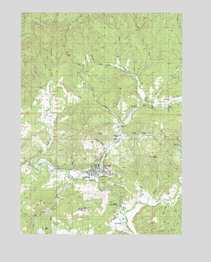
Drain, OR USGS Topographic Map
Click on map above to begin viewing in our Map Viewer.

This topographic map contains these locations and features:
Feature Name Type Latitude Longitude GNIS ID View Map
Anna Drain County ParkParkN43.6587°W123.3095°1116960View Map
Applegate Family CemeteryCemeteryN43.6274°W123.3059°1117020View Map
Asker CreekStreamN43.6440°W123.2618°1117067View Map
Bear CreekStreamN43.6368°W123.3534°1117367View Map
Bear HillSummitN43.6415°W123.3645°1117384View Map
Billy CreekStreamN43.6601°W123.3404°1117707View Map
Boswell Mineral SpringsLocaleN43.6410°W123.2998°1166619View Map
Boswell Post Office (historical)Post OfficeN43.6432°W123.2995°1164230View Map
Boswell SpringsSpringN43.6415°W123.2984°1159051View Map
City of DrainCivilN43.6620°W123.3143°2410354View Map
Cold Spring SchoolLocaleN43.7035°W123.3206°1119118View Map
Colvin CemeteryCemeteryN43.6928°W123.3458°1157166View Map
Dodge CanyonValleyN43.6415°W123.2581°1119989View Map
Douglas County Sheriff's Office Drain SubstationBuildingN43.6633°W123.3159°2737684View Map
Douglas Forest Protective Association North UnitBuildingN43.6583°W123.3187°2576676View Map
DrainPopulated PlaceN43.6587°W123.3187°1166647View Map
Drain Branch Mildred Whipple LibraryBuildingN43.6618°W123.3169°2661638View Map
Drain CemeteryCemeteryN43.6704°W123.3125°1133010View Map
Drain Church of the NazareneChurchN43.6631°W123.3183°2508116View Map
Drain City HallBuildingN43.6634°W123.3159°2661336View Map
Drain HillSummitN43.6538°W123.3051°1120067View Map
Drain IOOF CemeteryCemeteryN43.6543°W123.2948°1133008View Map
Drain Justice CourtBuildingN43.6626°W123.3164°2661334View Map
Drain Plywood Company DamDamN43.6565°W123.3295°1133505View Map
Drain Plywood Company Log PondReservoirN43.6578°W123.3287°1133506View Map
Drain Post OfficePost OfficeN43.6637°W123.3168°1165176View Map
Drain Public WorksBuildingN43.6599°W123.3240°2661557View Map
Drain Wastewater Treatment PlantLocaleN43.6582°W123.3252°2660682View Map
Drain Water Treatment PlantLocaleN43.6497°W123.3423°2660824View Map
Ellenburg CreekStreamN43.7182°W123.2968°1120481View Map
First Baptist Church of DrainChurchN43.6589°W123.3169°2508117View Map
Fitch CreekStreamN43.6873°W123.2979°1120791View Map
Green MountainSummitN43.6688°W123.2739°1136336View Map
Hardscrable CreekStreamN43.6651°W123.3706°1121596View Map
Hendrick CreekStreamN43.6610°W123.3095°1133009View Map
Homes Gallup BridgeBridgeN43.6585°W123.3393°1166781View Map
Hudson Post Office (historical)Post OfficeN43.6979°W123.2748°1164424View Map
Jessie Applegate Historical MarkerParkN43.6312°W123.2970°1157172View Map
Johnson CreekStreamN43.6818°W123.2995°1122467View Map
Krewson (historical)LocaleN43.6798°W123.3015°1136452View Map
Krewson CreekStreamN43.6723°W123.3101°1122840View Map
LeonaPopulated PlaceN43.6951°W123.2893°1166672View Map
Leona Post Office (historical)Post OfficeN43.6951°W123.2893°1165532View Map
Little Reservoir Number FiveReservoirN43.6824°W123.2984°1133682View Map
Little Sand CreekStreamN43.7096°W123.2854°1123272View Map
McClintock CreekStreamN43.6418°W123.2787°1123910View Map
Mount Baldy Log PondReservoirN43.6335°W123.2963°1159137View Map
Mount Baldy Log Pond DamDamN43.6348°W123.2962°1133617View Map
Mount YoncallaSummitN43.6388°W123.3272°1129388View Map
North Douglas County Fire and Emergency Medical Services Station 1BuildingN43.6583°W123.3188°2576487View Map
North Douglas Elementary SchoolSchoolN43.6618°W123.3092°2417823View Map
North Douglas High SchoolSchoolN43.6601°W123.3125°2559807View Map
Palmer (historical)LocaleN43.6404°W123.2993°1166450View Map
Pass CreekStreamN43.6615°W123.3184°1125208View Map
Pass Creek Post Office (historical)Post OfficeN43.6973°W123.2859°1164584View Map
Post CreekStreamN43.6601°W123.3406°1125591View Map
Reels SpringsSpringN43.6779°W123.2898°1157171View Map
Rock CreekStreamN43.6993°W123.2745°1126158View Map
SafleyLocaleN43.7012°W123.2609°1136720View Map
Sand CreekStreamN43.6990°W123.2795°1126554View Map
Sheep HillSummitN43.6281°W123.3576°1158478View Map
Smith CreekStreamN43.6873°W123.2984°1133012View Map
Smith River Log PondSwampN43.6665°W123.3594°1133011View Map
Smith River Lumber Company DamDamN43.6815°W123.2995°1133681View Map
Windy GapGapN43.7260°W123.3412°1129222View Map
Wise CreekStreamN43.6437°W123.2845°1129256View Map
Yoncalla CreekStreamN43.6382°W123.2970°1129387View Map

Note: Coordinates in the location and feature list above are referenced to NAD83 datum.


Copyright (C) 2008-2024 Ryan Niemi / Sunset Dynamics ... All Rights Reserved