TopoQuest Logo
Do you find TopoQuest useful?
Help keep TopoQuest running and adding new maps/features by donating!
Bitcoin:  19c7KJd3qBynnjoSw5npx9KScwjBe4ifkT
Litecoin:  LXs6TkuXGGXo1vDsWCkWVdjQX94eUKd6ui
Home View Maps Find Maps Find Places Resources & Links


Enfield, North Carolina Topographic Map

USGS Map Title: Enfield, NC
USGS Map MRC: 36077B6
DRG (GeoTIFF) Download: o36077b6.tif


Neighboring USGS Topographic Map Quads:


  Aurelian Springs, NC  
36077C7
 

  Darlington, NC  
36077C6
 

  Halifax, NC  
36077C5
 

  Ringwood, NC  
36077B7
 

  Enfield, NC  
36077B6
 

  Dawson Crossroads, NC  
36077B5
 

  Drake, NC  
36077A7
 

  Whitakers, NC  
36077A6
 

  Draughn, NC  
36077A5


Map MRC Location:

N37°
W78°
N37°
W77°
H8 H7 H6 H5 H4 H3 H2 H1
G8 G7 G6 G5 G4 G3 G2 G1
F8 F7 F6 F5 F4 F3 F2 F1
E8 E7 E6 E5 E4 E3 E2 E1
D8 D7 D6 D5 D4 D3 D2 D1
C8 C7 C6 C5 C4 C3 C2 C1
B8 B7 B6 B5 B4 B3 B2 B1
A8 A7 A6 A5 A4 A3 A2 A1
N36°
W78°
N36°
W77°

Enfield, NC USGS 1:24K Topographic Map Preview:
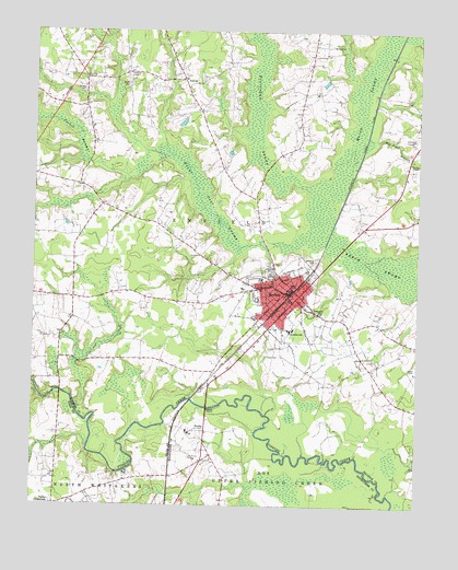
Enfield, NC USGS Topographic Map
Click on map above to begin viewing in our Map Viewer.

This topographic map contains these locations and features:
Feature Name Type Latitude Longitude GNIS ID View Map
Beaverdam SwampStreamN36.2074°W77.6544°980869View Map
Bellamys BridgeBridgeN36.1549°W77.7405°1006924View Map
Breeches SwampStreamN36.2171°W77.7069°981848View Map
BricksLocaleN36.1452°W77.6936°981868View Map
Bryant CemeteryCemeteryN36.2360°W77.7197°982077View Map
Burnt Coat SwampStreamN36.1968°W77.6586°982294View Map
Coefield CemeteryCemeteryN36.1889°W77.6588°983335View Map
Dog Pond BranchStreamN36.2227°W77.6414°979988View Map
Eden ChurchChurchN36.2377°W77.7014°984625View Map
Elmwood CemeteryCemeteryN36.1873°W77.6714°984754View Map
EnfieldPopulated PlaceN36.1810°W77.6666°1020153View Map
Enfield ChurchChurchN36.1765°W77.6578°984787View Map
Enfield Fire Department Station 1BuildingN36.1815°W77.6802°2638302View Map
Enfield Middle SchoolSchoolN36.1849°W77.6766°1006638View Map
Enfield Police DepartmentBuildingN36.1807°W77.6660°2130995View Map
Enfield Post OfficePost OfficeN36.1810°W77.6688°2774047View Map
Enfield-Shearin AirportAirportN36.2172°W77.6375°2679166View Map
Enfield-Shearin AirportAirportN36.2184°W77.6367°2787162View Map
Fishing Creek MillpondReservoirN36.1552°W77.7430°1000209View Map
Fishing Creek Millpond DamDamN36.1552°W77.7430°1000208View Map
Halifax Emergency Medical Services Station 2 - Enfield Rescue SquadBuildingN36.1812°W77.6821°2720522View Map
Hardee CemeteryCemeteryN36.2346°W77.7341°986389View Map
Inborden SchoolSchoolN36.1713°W77.6664°987328View Map
Jacket SwampStreamN36.2115°W77.7189°987469View Map
Marsh SwampStreamN36.2074°W77.6544°989375View Map
Old Bricks CemeteryCemeteryN36.1376°W77.6983°991534View Map
Overstreet CemeteryCemeteryN36.2215°W77.6261°991742View Map
Pettitt CemeteryCemeteryN36.1621°W77.6258°992105View Map
Pittman CemeteryCemeteryN36.2388°W77.7194°992431View Map
Pope CemeteryCemeteryN36.1649°W77.6700°992673View Map
Smiths ChapelChurchN36.2157°W77.6275°995002View Map
Town of EnfieldCivilN36.1802°W77.6677°2406450View Map
Township of EnfieldCivilN36.1884°W77.6530°1026751View Map
Wards CrossroadsLocaleN36.1793°W77.7366°1023554View Map
Willey CemeteryCemeteryN36.2465°W77.6539°997350View Map

Note: Coordinates in the location and feature list above are referenced to NAD83 datum.


Copyright (C) 2008-2024 Ryan Niemi / Sunset Dynamics ... All Rights Reserved