TopoQuest Logo
Do you find TopoQuest useful?
Help keep TopoQuest running and adding new maps/features by donating!
Bitcoin:  19c7KJd3qBynnjoSw5npx9KScwjBe4ifkT
Litecoin:  LXs6TkuXGGXo1vDsWCkWVdjQX94eUKd6ui
Home View Maps Find Maps Find Places Resources & Links


Drakes Branch, Virginia Topographic Map

USGS Map Title: Drakes Branch, VA
USGS Map MRC: 36078H5
DRG (GeoTIFF) Download: o36078h5.tif


Neighboring USGS Topographic Map Quads:


  Charlotte Court House, VA  
37078A6
 

  Eureka, VA  
37078A5
 

  Keysville, VA  
37078A4
 

  Saxe, VA  
36078H6
 

  Drakes Branch, VA  
36078H5
 

  Fort Mitchell, VA  
36078H4
 

  Clover, VA  
36078G6
 

  Wylliesburg, VA  
36078G5
 

  Chase City, VA  
36078G4


Map MRC Location:

N37°
W79°
N37°
W78°
H8 H7 H6 H5 H4 H3 H2 H1
G8 G7 G6 G5 G4 G3 G2 G1
F8 F7 F6 F5 F4 F3 F2 F1
E8 E7 E6 E5 E4 E3 E2 E1
D8 D7 D6 D5 D4 D3 D2 D1
C8 C7 C6 C5 C4 C3 C2 C1
B8 B7 B6 B5 B4 B3 B2 B1
A8 A7 A6 A5 A4 A3 A2 A1
N36°
W79°
N36°
W78°

Drakes Branch, VA USGS 1:24K Topographic Map Preview:
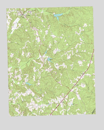
Drakes Branch, VA USGS Topographic Map
Click on map above to begin viewing in our Map Viewer.

This topographic map contains these locations and features:
Feature Name Type Latitude Longitude GNIS ID View Map
Bacon District Elementary SchoolSchoolN36.8884°W78.5659°1462663View Map
Cedar Grove ChurchChurchN36.9029°W78.6119°1464617View Map
Central DistrictCivilN36.9693°W78.5600°1927138View Map
Crafton GateLocaleN36.9096°W78.5286°1465392View Map
Delaney CreekStreamN36.9357°W78.5567°1465724View Map
Drakes BranchPopulated PlaceN36.9929°W78.6011°1465943View Map
Drakes Branch Police DepartmentBuildingN36.9935°W78.6025°2767090View Map
Drakes Branch Post OfficePost OfficeN36.9933°W78.6015°1492378View Map
Drakes Branch Volunteer Fire DepartmentBuildingN36.9934°W78.6023°2086334View Map
Horseshoe LakeReservoirN36.9402°W78.5648°1468315View Map
Jumpin BranchStreamN36.8893°W78.6089°1468898View Map
Langford PondReservoirN36.8875°W78.5343°1469127View Map
Lebanon ChurchChurchN36.9165°W78.5564°1469240View Map
Lickfort CreekStreamN36.9410°W78.5603°1469412View Map
Mount Calvary ChurchChurchN36.9921°W78.6033°1470821View Map
Organ Hill ChurchChurchN36.9826°W78.5914°1471950View Map
Organ Hill School (historical)SchoolN36.9818°W78.5903°1492412View Map
Reeses CreekStreamN36.9846°W78.5506°1473128View Map
Roanoke Creek Number 49a DamDamN36.9135°W78.5997°1489417View Map
Roanoke Creek Number 61a DamDamN36.9468°W78.5697°1489425View Map
Roanoke Creek Number 62 DamDamN36.9418°W78.5664°1489419View Map
Roanoke Creek Number 72a DamDamN36.9918°W78.5564°1489408View Map
Roanoke Creek Site 49a LakeReservoirN36.9123°W78.5956°1489418View Map
Roanoke Creek Site 61a LakeReservoirN36.9481°W78.5692°1489426View Map
Shiloh ChurchChurchN36.8899°W78.5478°1474503View Map
Tabernacle ChurchChurchN36.9226°W78.5161°1475426View Map
Town of Drakes BranchCivilN36.9934°W78.6010°2390149View Map

Note: Coordinates in the location and feature list above are referenced to NAD83 datum.


Copyright (C) 2008-2025 Ryan Niemi / Sunset Dynamics ... All Rights Reserved