TopoQuest Logo
Do you find TopoQuest useful?
Help keep TopoQuest running and adding new maps/features by donating!
Bitcoin:  19c7KJd3qBynnjoSw5npx9KScwjBe4ifkT
Litecoin:  LXs6TkuXGGXo1vDsWCkWVdjQX94eUKd6ui
Home View Maps Find Maps Find Places Resources & Links


Wylliesburg, Virginia Topographic Map

USGS Map Title: Wylliesburg, VA
USGS Map MRC: 36078G5
DRG (GeoTIFF) Download: o36078g5.tif


Neighboring USGS Topographic Map Quads:


  Saxe, VA  
36078H6
 

  Drakes Branch, VA  
36078H5
 

  Fort Mitchell, VA  
36078H4
 

  Clover, VA  
36078G6
 

  Wylliesburg, VA  
36078G5
 

  Chase City, VA  
36078G4
 

  Buffalo Springs, VA  
36078F6
 

  Clarksville North, VA  
36078F5
 

  Boydton, VA  
36078F4


Map MRC Location:

N37°
W79°
N37°
W78°
H8 H7 H6 H5 H4 H3 H2 H1
G8 G7 G6 G5 G4 G3 G2 G1
F8 F7 F6 F5 F4 F3 F2 F1
E8 E7 E6 E5 E4 E3 E2 E1
D8 D7 D6 D5 D4 D3 D2 D1
C8 C7 C6 C5 C4 C3 C2 C1
B8 B7 B6 B5 B4 B3 B2 B1
A8 A7 A6 A5 A4 A3 A2 A1
N36°
W79°
N36°
W78°

Wylliesburg, VA USGS 1:24K Topographic Map Preview:
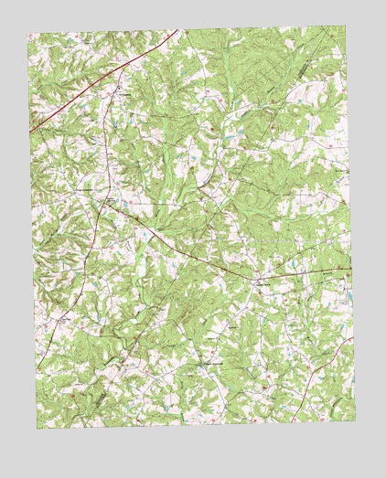
Wylliesburg, VA USGS Topographic Map
Click on map above to begin viewing in our Map Viewer.

This topographic map contains these locations and features:
Feature Name Type Latitude Longitude GNIS ID View Map
Antioch Baptist ChurchChurchN36.7740°W78.6206°1462494View Map
Apostolic Church of Jesus ChristChurchN36.8054°W78.5164°2057284View Map
Bacon DistrictCivilN36.8460°W78.6111°1927083View Map
Bacon District Volunteer Fire DepartmentBuildingN36.8395°W78.5946°2057292View Map
Barnes JunctionPopulated PlaceN36.8207°W78.5956°1477095View Map
Bethel Baptist ChurchChurchN36.7804°W78.5478°1463163View Map
Bethel CemeteryCemeteryN36.7801°W78.5486°1500611View Map
Black BranchStreamN36.8165°W78.5117°1463468View Map
Bluestone Baptist ChurchChurchN36.7771°W78.5519°1463600View Map
Brewers BranchStreamN36.7801°W78.5181°1463795View Map
Charlotte County Volunteer Rescue Squad Station 2 WylliesburgBuildingN36.8576°W78.5889°2721132View Map
Chase City Municipal AirportAirportN36.7919°W78.5029°1498625View Map
Church of Jesus Christ of Latter Day SaintsChurchN36.8238°W78.6056°2057293View Map
Devils BranchStreamN36.8463°W78.5464°1465744View Map
Evdaileys Store (historical)LocaleN36.7654°W78.5161°1500689View Map
First Baptist ChurchChurchN36.8490°W78.5836°2057290View Map
Hazen BranchStreamN36.7801°W78.5178°1467884View Map
Hebron United Methodist ChurchChurchN36.8718°W78.6019°2057287View Map
Kings CrossroadsPopulated PlaceN36.8240°W78.6075°1477463View Map
Little Moody CreekStreamN36.8207°W78.5728°1469597View Map
Moody CreekStreamN36.8118°W78.5758°1470697View Map
Oak School (historical)SchoolN36.7560°W78.5506°1500772View Map
Otter CreekStreamN36.8118°W78.5761°1471964View Map
Philbeck CrossroadsPopulated PlaceN36.7696°W78.5589°1477620View Map
Red OakLocaleN36.7843°W78.6150°1473057View Map
Red Oak Post OfficePost OfficeN36.7847°W78.6138°1492424View Map
Spanish GrovePopulated PlaceN36.7957°W78.5353°1477775View Map
Tanyard BranchStreamN36.8046°W78.5814°1475460View Map
The Lighthouse ChurchChurchN36.7987°W78.5072°2057285View Map
Woodpecker CreekStreamN36.7568°W78.5053°1476960View Map
WylliesburgPopulated PlaceN36.8554°W78.5903°1477737View Map
Wylliesburg Baptist ChurchChurchN36.8576°W78.5886°2057288View Map
Wylliesburg Post OfficePost OfficeN36.8564°W78.5910°1492441View Map
Wylliesburg Presbyterian ChurchChurchN36.8543°W78.5975°2057289View Map
Yerbys CreekStreamN36.7751°W78.5883°1474345View Map

Note: Coordinates in the location and feature list above are referenced to NAD83 datum.


Copyright (C) 2008-2025 Ryan Niemi / Sunset Dynamics ... All Rights Reserved