TopoQuest Logo
Do you find TopoQuest useful?
Help keep TopoQuest running and adding new maps/features by donating!
Bitcoin:  19c7KJd3qBynnjoSw5npx9KScwjBe4ifkT
Litecoin:  LXs6TkuXGGXo1vDsWCkWVdjQX94eUKd6ui
Home View Maps Find Maps Find Places Resources & Links


Drexel, North Carolina Topographic Map

USGS Map Title: Drexel, NC
USGS Map MRC: 35081G5
DRG (GeoTIFF) Download: o35081g5.tif


Neighboring USGS Topographic Map Quads:


  Collettsville, NC  
35081H6
 

  Lenoir, NC  
35081H5
 

  Kings Creek, NC  
35081H4
 

  Morganton North, NC  
35081G6
 

  Drexel, NC  
35081G5
 

  Granite Falls, NC  
35081G4
 

  Morganton South, NC  
35081F6
 

  Valdese, NC  
35081F5
 

  Longview, NC  
35081F4


Map MRC Location:

N36°
W82°
N36°
W81°
H8 H7 H6 H5 H4 H3 H2 H1
G8 G7 G6 G5 G4 G3 G2 G1
F8 F7 F6 F5 F4 F3 F2 F1
E8 E7 E6 E5 E4 E3 E2 E1
D8 D7 D6 D5 D4 D3 D2 D1
C8 C7 C6 C5 C4 C3 C2 C1
B8 B7 B6 B5 B4 B3 B2 B1
A8 A7 A6 A5 A4 A3 A2 A1
N35°
W82°
N35°
W81°

Drexel, NC USGS 1:24K Topographic Map Preview:
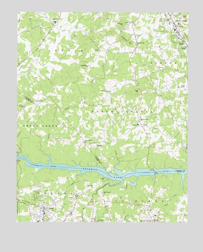
Drexel, NC USGS Topographic Map
Click on map above to begin viewing in our Map Viewer.

This topographic map contains these locations and features:
Feature Name Type Latitude Longitude GNIS ID View Map
Abernethy Memorial ChurchChurchN35.7515°W81.5254°1008646View Map
AmherstPopulated PlaceN35.7990°W81.5962°1018812View Map
Antioch ChurchChurchN35.8179°W81.6195°980235View Map
BatonPopulated PlaceN35.8074°W81.5318°980620View Map
Baton Elementary SchoolSchoolN35.8085°W81.5359°1001500View Map
Bradford MountainSummitN35.8674°W81.5476°1019274View Map
Cajah MountainSummitN35.8276°W81.5368°1019468View Map
Cajah Mountain Baptist ChurchChurchN35.8251°W81.5331°1007849View Map
Cajahs MountainPopulated PlaceN35.8349°W81.5415°1027621View Map
Caldwell Correctional CenterBuildingN35.8551°W81.5207°2769831View Map
Calico PlacePopulated PlaceN35.8437°W81.6093°1006083View Map
Castle BridgeBridgeN35.7799°W81.5240°982737View Map
Celia CreekStreamN35.8579°W81.6237°1019589View Map
Clarks ChapelChurchN35.8524°W81.5645°1000740View Map
CloverdalePopulated PlaceN35.8665°W81.5801°1006087View Map
Colliers ChurchChurchN35.8690°W81.5404°983380View Map
Copenhagen (historical)Populated PlaceN35.8657°W81.5993°1001504View Map
Corpening BridgeBridgeN35.8404°W81.6165°983581View Map
DrexelPopulated PlaceN35.7579°W81.6043°1020029View Map
Drexel Fire DepartmentBuildingN35.7570°W81.6059°2638498View Map
Drexel Police DepartmentBuildingN35.7572°W81.6064°2769605View Map
Drexel Post OfficePost OfficeN35.7570°W81.6062°2774260View Map
Dye BranchStreamN35.7537°W81.5773°984459View Map
Eastern Burke County Rescue SquadBuildingN35.7505°W81.5690°2720657View Map
Enon ChurchChurchN35.7554°W81.5845°984809View Map
Fairway AcresPopulated PlaceN35.8332°W81.5351°1006091View Map
Foothills Regional AirportAirportN35.8224°W81.6122°997977View Map
Forest HillsPopulated PlaceN35.8479°W81.5293°1006093View Map
GamewellPopulated PlaceN35.8693°W81.5962°985535View Map
Gamewell Elementary SchoolSchoolN35.8687°W81.5976°1001508View Map
Gamewell HeightsPopulated PlaceN35.8643°W81.6165°1006086View Map
Gamewell Middle SchoolSchoolN35.8740°W81.6034°1001509View Map
Gamewell Volunteer Fire DepartmentBuildingN35.8739°W81.5926°2638390View Map
Hampton HeightsPopulated PlaceN35.8457°W81.5212°1006092View Map
Harris ChapelChurchN35.8307°W81.5051°1000752View Map
High Hills Golf CourseLocaleN35.8735°W81.6112°1001514View Map
Howard CreekStreamN35.7801°W81.5762°987179View Map
Hoyle CreekStreamN35.7776°W81.5356°987200View Map
Huffman BridgeBridgeN35.7868°W81.6245°987219View Map
Husband CreekStreamN35.8368°W81.6245°1012313View Map
Island CreekStreamN35.7787°W81.5037°987423View Map
Johnson DevelopmentPopulated PlaceN35.8518°W81.5051°1006095View Map
JoycetonPopulated PlaceN35.8674°W81.5079°1020992View Map
Jumping BranchStreamN35.7907°W81.6226°987814View Map
Lakeview ChurchChurchN35.7715°W81.5737°988097View Map
Lakeview Mission ChurchChurchN35.8576°W81.5059°988101View Map
Linville River (historical)Populated PlaceN35.7926°W81.5106°1001517View Map
Lovelady (historical)Populated PlaceN35.7946°W81.5684°1001474View Map
Lovelady ChurchChurchN35.7946°W81.5662°989062View Map
McGalliard CreekStreamN35.7757°W81.5481°989575View Map
Micol CreekStreamN35.7546°W81.5418°989760View Map
Mount Zion ChurchChurchN35.7651°W81.5815°990659View Map
Mountain Grove ChurchChurchN35.8115°W81.5354°1000767View Map
North Catawba CemeteryCemeteryN35.7968°W81.5712°991205View Map
North Catawba ChurchChurchN35.7974°W81.5762°1000769View Map
North Catawba Fire / Rescue DepartmentBuildingN35.8335°W81.5390°2638104View Map
North Laurel ChurchChurchN35.7676°W81.5620°991242View Map
Oakmont EstatesPopulated PlaceN35.8468°W81.5443°1006096View Map
Philadelphia ChurchChurchN35.8432°W81.5729°992127View Map
PineburrPopulated PlaceN35.8554°W81.6040°1006085View Map
PinehurstPopulated PlaceN35.8526°W81.6065°1006084View Map
Pleasant Hill ChurchChurchN35.8571°W81.5376°992535View Map
Puett CemeteryCemeteryN35.8701°W81.6165°992892View Map
Rambling AcresPopulated PlaceN35.8285°W81.5554°1006090View Map
Rippetoe MountainSummitN35.8565°W81.5423°1022296View Map
Secrets CreekStreamN35.7718°W81.5859°994475View Map
Smokey CreekPopulated PlaceN35.8168°W81.5698°1006082View Map
Smoky CreekStreamN35.7846°W81.6004°995017View Map
Stafford CreekStreamN35.7790°W81.5490°995394View Map
Sycamore AcresPopulated PlaceN35.8615°W81.5854°1006088View Map
Town and CountryPopulated PlaceN35.8485°W81.5887°1006089View Map
Town of Cajah's MountainCivilN35.8507°W81.5361°2405357View Map
Town of DrexelCivilN35.7568°W81.6088°2406396View Map
Town of GamewellCivilN35.8637°W81.5979°2406538View Map
Town of Rutherford CollegeCivilN35.7508°W81.5269°2407261View Map
Township of DrexelCivilN35.7553°W81.6004°1026457View Map
Township of North CatawbaCivilN35.8116°W81.5435°1026491View Map
Township of Smoky CreekCivilN35.8021°W81.6109°1026467View Map
Tri County Golf CourseLocaleN35.8087°W81.5304°1007848View Map
Union Grove ChurchChurchN35.8279°W81.5584°1000792View Map
Zion MethodistChurchN35.7629°W81.6243°1007725View Map

Note: Coordinates in the location and feature list above are referenced to NAD83 datum.


Copyright (C) 2008-2024 Ryan Niemi / Sunset Dynamics ... All Rights Reserved