TopoQuest Logo
Do you find TopoQuest useful?
Help keep TopoQuest running and adding new maps/features by donating!
Bitcoin:  19c7KJd3qBynnjoSw5npx9KScwjBe4ifkT
Litecoin:  LXs6TkuXGGXo1vDsWCkWVdjQX94eUKd6ui
Home View Maps Find Maps Find Places Resources & Links


Granite Falls, North Carolina Topographic Map

USGS Map Title: Granite Falls, NC
USGS Map MRC: 35081G4
DRG (GeoTIFF) Download: o35081g4.tif


Neighboring USGS Topographic Map Quads:


  Lenoir, NC  
35081H5
 

  Kings Creek, NC  
35081H4
 

  Ellendale, NC  
35081H3
 

  Drexel, NC  
35081G5
 

  Granite Falls, NC  
35081G4
 

  Bethlehem, NC  
35081G3
 

  Valdese, NC  
35081F5
 

  Longview, NC  
35081F4
 

  Hickory, NC  
35081F3


Map MRC Location:

N36°
W82°
N36°
W81°
H8 H7 H6 H5 H4 H3 H2 H1
G8 G7 G6 G5 G4 G3 G2 G1
F8 F7 F6 F5 F4 F3 F2 F1
E8 E7 E6 E5 E4 E3 E2 E1
D8 D7 D6 D5 D4 D3 D2 D1
C8 C7 C6 C5 C4 C3 C2 C1
B8 B7 B6 B5 B4 B3 B2 B1
A8 A7 A6 A5 A4 A3 A2 A1
N35°
W82°
N35°
W81°

Granite Falls, NC USGS 1:24K Topographic Map Preview:
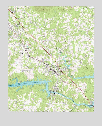
Granite Falls, NC USGS Topographic Map
Click on map above to begin viewing in our Map Viewer.

This topographic map contains these locations and features:
Feature Name Type Latitude Longitude GNIS ID View Map
Angley CreekStreamN35.8621°W81.4954°980194View Map
Baird (historical)Populated PlaceN35.7882°W81.4054°1001499View Map
Bethel ChurchChurchN35.8585°W81.4868°981152View Map
Billy BranchStreamN35.8062°W81.4193°981491View Map
Brushy ForkStreamN35.8657°W81.4951°982064View Map
Caldwell Community CollegeSchoolN35.8546°W81.4840°982415View Map
Caldwell County FairgroundsLocaleN35.8601°W81.4898°1007843View Map
Center Grove ChurchChurchN35.8343°W81.4412°1000738View Map
Chestnut MountainSummitN35.8718°W81.4501°983116View Map
Clove ChurchChurchN35.8118°W81.4490°1000742View Map
Concord Baptist ChurchChurchN35.8004°W81.4215°1007846View Map
Devil ShoalsBarN35.7585°W81.3956°1001459View Map
Drowning CreekStreamN35.7582°W81.4009°984337View Map
Dry Pond Union ChurchChurchN35.7979°W81.4765°984368View Map
Dudley ShoalsPopulated PlaceN35.8637°W81.3765°1020042View Map
East Hudson ChurchChurchN35.8604°W81.4829°984511View Map
Ebenezer ChurchChurchN35.8660°W81.3831°984602View Map
Fellowship ChurchChurchN35.7624°W81.4954°985040View Map
Freemason CreekStreamN35.7915°W81.4998°985394View Map
Friendship ChurchChurchN35.7593°W81.4423°985447View Map
Grace ChapelPopulated PlaceN35.8215°W81.3801°1006081View Map
Grace ChapelChurchN35.8218°W81.3795°985882View Map
Granada Golf CourseLocaleN35.8032°W81.4059°1001510View Map
Granite FallsPopulated PlaceN35.7965°W81.4306°1020491View Map
Granite Falls Elementary SchoolSchoolN35.8068°W81.4351°1001512View Map
Granite Falls Fire DepartmentBuildingN35.8026°W81.4398°2638429View Map
Granite Falls First Baptist ChurchChurchN35.7971°W81.4284°1007845View Map
Granite Falls Middle SchoolSchoolN35.8001°W81.4381°1007844View Map
Granite Falls Police DepartmentBuildingN35.7978°W81.4310°2769772View Map
Granite Falls Post OfficePost OfficeN35.7986°W81.4343°2768294View Map
Granville TerracePopulated PlaceN35.8099°W81.4120°1006080View Map
Hayes Mill CreekStreamN35.7874°W81.4562°986546View Map
HudsonPopulated PlaceN35.8485°W81.4959°987211View Map
Hudson Drag StripLocaleN35.8724°W81.4720°987215View Map
Hudson Elementary SchoolSchoolN35.8454°W81.4901°1007839View Map
Hudson Fire DepartmentBuildingN35.8513°W81.4953°2638125View Map
Hudson First Baptist ChurchChurchN35.8371°W81.4984°1007840View Map
Hudson Middle SchoolSchoolN35.8482°W81.4790°1007841View Map
Hudson Police DepartmentBuildingN35.8471°W81.4953°2769651View Map
Hudson Post OfficePost OfficeN35.8481°W81.4962°2768295View Map
Jumping RunStreamN35.7765°W81.4462°987818View Map
Liberty Church CemeteryCemeteryN35.7504°W81.4173°988424View Map
Little DamDamN35.7929°W81.4070°988620View Map
Little Gunpowder CreekStreamN35.8215°W81.4287°988657View Map
Lovelady ChurchChurchN35.8246°W81.4223°1000758View Map
Lovelady Rescue SquadBuildingN35.7904°W81.4148°2720714View Map
MayfieldPopulated PlaceN35.8187°W81.4815°1006079View Map
Mount Zion ChurchChurchN35.8290°W81.4815°1000766View Map
Mountain View DevelopmentPopulated PlaceN35.8660°W81.4968°1006094View Map
Nolden CreekStreamN35.7804°W81.4795°991174View Map
North LakesPopulated PlaceN35.7757°W81.3751°1006075View Map
NorthlakesPopulated PlaceN35.7818°W81.3751°1867436View Map
Oak Grove ChurchChurchN35.8085°W81.3959°1000770View Map
Oak Ridge ChurchChurchN35.7540°W81.4804°991443View Map
Old Mill PondReservoirN35.8001°W81.4115°999468View Map
Old Mill Pond DamDamN35.8001°W81.4115°999467View Map
Old MillpondReservoirN35.8090°W81.4154°991586View Map
Pilot MountainSummitN35.8715°W81.4109°992214View Map
Pine Mountain CampgroundLocaleN35.8565°W81.4620°992274View Map
Pinecrest CemeteryCemeteryN35.8021°W81.4365°992303View Map
PinewoodPopulated PlaceN35.8232°W81.4698°1006077View Map
Poovey ChapelChurchN35.8551°W81.4609°1000777View Map
Pooveys Grove ChurchChurchN35.7735°W81.3898°1000778View Map
RhodhissPopulated PlaceN35.7740°W81.4312°1022237View Map
Rhodhiss DamDamN35.7732°W81.4380°993272View Map
Rhodhiss LakeReservoirN35.7732°W81.4384°1000779View Map
Rhodhiss Police DepartmentBuildingN35.7695°W81.4322°2770026View Map
Rhodhiss Post OfficePost OfficeN35.7777°W81.4294°2768302View Map
Rhodhiss Volunteer Fire DepartmentBuildingN35.7695°W81.4322°2639197View Map
Rhodiss Baptist ChurchChurchN35.7776°W81.4273°1007847View Map
Sardis (historical)Populated PlaceN35.8679°W81.4740°1001519View Map
SawmillsPopulated PlaceN35.8249°W81.4745°1027457View Map
Sawmills SchoolSchoolN35.8187°W81.4790°1001520View Map
Sawmills Volunteer Fire DepartmentBuildingN35.8250°W81.4745°2638303View Map
Shady Grove ChurchChurchN35.7537°W81.4973°994551View Map
Silver CreekStreamN35.7937°W81.3759°994811View Map
South Caldwell High SchoolSchoolN35.8221°W81.4465°1001521View Map
Sunrise Baptist ChurchChurchN35.8290°W81.4723°1007842View Map
Sunset Hill CemeteryCemeteryN35.8126°W81.4490°995708View Map
Temple Hill ChurchChurchN35.8624°W81.3965°1000790View Map
Town of Connelly SpringsCivilN35.7550°W81.4970°2406306View Map
Town of Granite FallsCivilN35.7965°W81.4234°2406601View Map
Town of HudsonCivilN35.8475°W81.4865°2405871View Map
Town of RhodhissCivilN35.7683°W81.4312°2407204View Map
Town of SawmillsCivilN35.8162°W81.4779°2407295View Map
Township of HudsonCivilN35.8497°W81.4806°1026483View Map
Township of LoveladyCivilN35.8095°W81.4108°1026488View Map
WKJK-AM (Granite Falls)TowerN35.7862°W81.4165°1018497View Map

Note: Coordinates in the location and feature list above are referenced to NAD83 datum.


Copyright (C) 2008-2025 Ryan Niemi / Sunset Dynamics ... All Rights Reserved