TopoQuest Logo
Do you find TopoQuest useful?
Help keep TopoQuest running and adding new maps/features by donating!
Bitcoin:  19c7KJd3qBynnjoSw5npx9KScwjBe4ifkT
Litecoin:  LXs6TkuXGGXo1vDsWCkWVdjQX94eUKd6ui
Home View Maps Find Maps Find Places Resources & Links


Morganton North, North Carolina Topographic Map

USGS Map Title: Morganton North, NC
USGS Map MRC: 35081G6
DRG (GeoTIFF) Download: o35081g6.tif


Neighboring USGS Topographic Map Quads:


  Chestnut Mountain, NC  
35081H7
 

  Collettsville, NC  
35081H6
 

  Lenoir, NC  
35081H5
 

  Oak Hill, NC  
35081G7
 

  Morganton North, NC  
35081G6
 

  Drexel, NC  
35081G5
 

  Glen Alpine, NC  
35081F7
 

  Morganton South, NC  
35081F6
 

  Valdese, NC  
35081F5


Map MRC Location:

N36°
W82°
N36°
W81°
H8 H7 H6 H5 H4 H3 H2 H1
G8 G7 G6 G5 G4 G3 G2 G1
F8 F7 F6 F5 F4 F3 F2 F1
E8 E7 E6 E5 E4 E3 E2 E1
D8 D7 D6 D5 D4 D3 D2 D1
C8 C7 C6 C5 C4 C3 C2 C1
B8 B7 B6 B5 B4 B3 B2 B1
A8 A7 A6 A5 A4 A3 A2 A1
N35°
W82°
N35°
W81°

Morganton North, NC USGS 1:24K Topographic Map Preview:
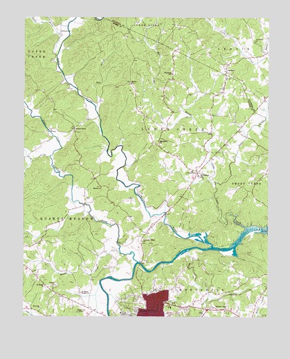
Morganton North, NC USGS Topographic Map
Click on map above to begin viewing in our Map Viewer.

This topographic map contains these locations and features:
Feature Name Type Latitude Longitude GNIS ID View Map
Amherst Baptist ChurchChurchN35.7674°W81.6329°1007724View Map
Arneys Chapel Methodist ChurchChurchN35.8190°W81.7234°1007722View Map
Arneys StoreLocaleN35.8285°W81.7243°980288View Map
Bethel ChurchChurchN35.8479°W81.6957°1000730View Map
Bost CemeteryCemeteryN35.7996°W81.7179°981749View Map
Bristol CreekStreamN35.8054°W81.6520°1019304View Map
Burke County Rescue SquadBuildingN35.7593°W81.7200°2720590View Map
Calvary ChurchChurchN35.7629°W81.7332°982453View Map
Cascade ParkParkN35.7526°W81.6940°1001455View Map
Catawba Valley Baptist Church CemeteryCemeteryN35.7815°W81.6887°2779068View Map
Catawba Valley ChurchChurchN35.7815°W81.6890°1000736View Map
Causby QuarryMineN35.7697°W81.6567°2648481View Map
ChesterfieldPopulated PlaceN35.8101°W81.6609°1019623View Map
Chesterfield Fire and RescueBuildingN35.8128°W81.6574°2638438View Map
Chesterfield SchoolSchoolN35.8110°W81.6637°1001457View Map
Collins (historical)Populated PlaceN35.8565°W81.7329°1001502View Map
Corpening SchoolSchoolN35.8518°W81.6743°983582View Map
El Bethel ChurchChurchN35.7629°W81.7387°1000746View Map
Erwin CemeteryCemeteryN35.7996°W81.6959°1011102View Map
Forest Hill CemeteryCemeteryN35.7517°W81.6752°2779065View Map
HartlandPopulated PlaceN35.8532°W81.6462°986469View Map
Hartland Baptist ChurchChurchN35.8562°W81.6495°1007836View Map
Hillcrest Elementary SchoolSchoolN35.7540°W81.6743°1001470View Map
Houck CemeteryCemeteryN35.8715°W81.6709°987162View Map
Hunting CreekStreamN35.7776°W81.6659°987263View Map
Irish CreekStreamN35.8165°W81.7365°1012371View Map
Johns RiverStreamN35.7793°W81.6532°1012515View Map
Littlejohn ChurchChurchN35.8651°W81.6318°988810View Map
Lower CreekStreamN35.7874°W81.6357°1013239View Map
M L King ParkParkN35.7521°W81.7007°1001709View Map
Mission ChurchChurchN35.8040°W81.7104°1000762View Map
Missionary ChurchChurchN35.8235°W81.6818°990084View Map
Morganton Department of Public Safety Station 1BuildingN35.7509°W81.6875°2639149View Map
Mount Pleasant ChurchChurchN35.8090°W81.6607°1000765View Map
Mountain View Elementary SchoolSchoolN35.7535°W81.7018°1001479View Map
Mountain View Recreation CenterParkN35.7512°W81.7001°1001480View Map
Parks CreekStreamN35.8593°W81.7334°1014232View Map
Pearcey CreekStreamN35.8732°W81.7368°1014292View Map
PerkinsvillePopulated PlaceN35.8693°W81.7318°1021868View Map
Piedmont Park SubdivisionPopulated PlaceN35.8279°W81.7359°1005956View Map
Pleasant View ChurchChurchN35.7524°W81.6465°992579View Map
Quaker Meadows Golf ClubLocaleN35.7640°W81.7087°1001486View Map
Riverside ChurchChurchN35.7532°W81.7407°993393View Map
Saint Marys Mission ChurchChurchN35.7601°W81.7207°994041View Map
Shadow Line ParkParkN35.7929°W81.6601°1007723View Map
Sims BranchStreamN35.8376°W81.7132°994854View Map
Spencer HeightsPopulated PlaceN35.8585°W81.6259°1006069View Map
Township of Lower CreekCivilN35.8314°W81.6789°1026462View Map
Township of Quaker MeadowsCivilN35.7847°W81.7441°1026465View Map
Upper CreekStreamN35.8168°W81.7365°1016332View Map
Wards CreekStreamN35.7754°W81.6404°1001707View Map
Warrior ForkStreamN35.7729°W81.6912°996813View Map
White Mill CreekStreamN35.8337°W81.6640°997149View Map
Wilson CreekStreamN35.7771°W81.7004°997448View Map
WMNC-AM (Morganton)TowerN35.7526°W81.7173°1018491View Map
WorryPopulated PlaceN35.8271°W81.7373°1023327View Map
WQXX-FM (Morganton)TowerN35.7526°W81.7218°1018299View Map

Note: Coordinates in the location and feature list above are referenced to NAD83 datum.


Copyright (C) 2008-2024 Ryan Niemi / Sunset Dynamics ... All Rights Reserved