TopoQuest Logo
Do you find TopoQuest useful?
Help keep TopoQuest running and adding new maps/features by donating!
Bitcoin:  19c7KJd3qBynnjoSw5npx9KScwjBe4ifkT
Litecoin:  LXs6TkuXGGXo1vDsWCkWVdjQX94eUKd6ui
Home View Maps Find Maps Find Places Resources & Links


Longview, North Carolina Topographic Map

USGS Map Title: Longview, NC
USGS Map MRC: 35081F4
DRG (GeoTIFF) Download: o35081f4.tif


Neighboring USGS Topographic Map Quads:


  Drexel, NC  
35081G5
 

  Granite Falls, NC  
35081G4
 

  Bethlehem, NC  
35081G3
 

  Valdese, NC  
35081F5
 

  Longview, NC  
35081F4
 

  Hickory, NC  
35081F3
 

  Casar, NC  
35081E5
 

  Banoak, NC  
35081E4
 

  Reepsville, NC  
35081E3


Map MRC Location:

N36°
W82°
N36°
W81°
H8 H7 H6 H5 H4 H3 H2 H1
G8 G7 G6 G5 G4 G3 G2 G1
F8 F7 F6 F5 F4 F3 F2 F1
E8 E7 E6 E5 E4 E3 E2 E1
D8 D7 D6 D5 D4 D3 D2 D1
C8 C7 C6 C5 C4 C3 C2 C1
B8 B7 B6 B5 B4 B3 B2 B1
A8 A7 A6 A5 A4 A3 A2 A1
N35°
W82°
N35°
W81°

Longview, NC USGS 1:24K Topographic Map Preview:
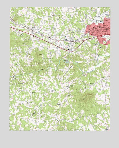
Longview, NC USGS Topographic Map
Click on map above to begin viewing in our Map Viewer.

This topographic map contains these locations and features:
Feature Name Type Latitude Longitude GNIS ID View Map
Abee CreekStreamN35.6796°W81.4945°980017View Map
Advent CrossroadsPopulated PlaceN35.6693°W81.4259°980059View Map
Baker MountainSummitN35.6576°W81.4062°1018908View Map
Baker Mountain ChurchChurchN35.6671°W81.3870°980448View Map
Berea ChurchChurchN35.7337°W81.4931°1000728View Map
Bethel CemeteryCemeteryN35.7338°W81.3847°981104View Map
Brookford CemeteryCemeteryN35.6713°W81.4002°981964View Map
Burke ChapelLocaleN35.6551°W81.4726°1007726View Map
Burke ChapelChurchN35.6632°W81.4715°982273View Map
Burke County Emergency Services Station 4BuildingN35.7153°W81.4277°2720428View Map
Camp CreekStreamN35.6296°W81.4101°982519View Map
Camp SainLocaleN35.7082°W81.3990°982549View Map
Drowning Creek (historical)Populated PlaceN35.7301°W81.4784°1001460View Map
Drowning Creek Volunteer Fire DepartmentBuildingN35.7471°W81.3963°2638631View Map
East Burke High SchoolSchoolN35.7221°W81.4784°1001461View Map
East Burke Junior High SchoolSchoolN35.7146°W81.4684°1001462View Map
Faith Olive ChurchChurchN35.6518°W81.4368°984960View Map
Full Gospel ChurchChurchN35.6674°W81.4873°985491View Map
Grace and Truth ChurchChurchN35.6729°W81.4826°985878View Map
Hatterbrond (historical)Populated PlaceN35.6812°W81.4926°1001468View Map
Henry RiverPopulated PlaceN35.6965°W81.4284°1020686View Map
Henry River DamDamN35.6935°W81.4265°999267View Map
Henry River LakeReservoirN35.6935°W81.4265°999266View Map
Hickory Fire Department Station 4 AirportBuildingN35.7425°W81.3880°2639762View Map
Hickory Regional AirportAirportN35.7411°W81.3895°997963View Map
HildebranPopulated PlaceN35.7140°W81.4220°986786View Map
Hildebran Post OfficePost OfficeN35.7142°W81.4205°2774284View Map
IcardPopulated PlaceN35.7274°W81.4706°987314View Map
Icard Census Designated PlaceCensusN35.7253°W81.4582°2402608View Map
Icard Elementary SchoolSchoolN35.7287°W81.4687°1001471View Map
Icard Post OfficePost OfficeN35.7187°W81.4690°2774288View Map
Icard Township Fire and RescueBuildingN35.7160°W81.4246°2638815View Map
Long View Fire DepartmentBuildingN35.7293°W81.3790°2638525View Map
Long View Police DepartmentBuildingN35.7294°W81.3793°2766630View Map
LongviewPopulated PlaceN35.7293°W81.3834°1027421View Map
Longview Elementary SchoolSchoolN35.7279°W81.3800°1006485View Map
Lords House ChurchChurchN35.6679°W81.3873°989030View Map
Meadow Brook VillagePopulated PlaceN35.6746°W81.3826°1021398View Map
Midway ChurchChurchN35.7262°W81.4231°989826View Map
Miller BridgeBridgeN35.6796°W81.4943°989996View Map
Mount Harmony ChurchChurchN35.7271°W81.4593°990391View Map
Mount Hebron ChurchChurchN35.6910°W81.4901°1008211View Map
Mountain Grove ChurchChurchN35.6729°W81.3945°990696View Map
Mountain View Volunteer Fire Department Station 12BuildingN35.6806°W81.3783°2638942View Map
PenelopePopulated PlaceN35.7290°W81.3998°1021862View Map
Piney MountainSummitN35.7018°W81.4634°992380View Map
Propst CrossroadsPopulated PlaceN35.6274°W81.3756°1022090View Map
Providence ChurchChurchN35.6307°W81.4395°992872View Map
Royal ChapelChurchN35.6668°W81.4304°993784View Map
Shoups Grove ChurchChurchN35.7093°W81.4690°994778View Map
South Fork ChurchChurchN35.6982°W81.4504°995145View Map
Southwest SchoolSchoolN35.7096°W81.3870°995261View Map
Tims CreekStreamN35.6862°W81.4623°996115View Map
Town of HildebranCivilN35.7182°W81.4210°2405835View Map
Town of Long ViewCivilN35.7216°W81.3858°2406040View Map
Township of IcardCivilN35.7125°W81.4717°1026458View Map
Warlick ChurchChurchN35.7418°W81.4426°1000797View Map
Wilkies ChurchChurchN35.6526°W81.4745°1000799View Map
WUIV-AM (Icard Township)TowerN35.7187°W81.4681°1018482View Map

Note: Coordinates in the location and feature list above are referenced to NAD83 datum.


Copyright (C) 2008-2024 Ryan Niemi / Sunset Dynamics ... All Rights Reserved