TopoQuest Logo
Do you find TopoQuest useful?
Help keep TopoQuest running and adding new maps/features by donating!
Bitcoin:  19c7KJd3qBynnjoSw5npx9KScwjBe4ifkT
Litecoin:  LXs6TkuXGGXo1vDsWCkWVdjQX94eUKd6ui
Home View Maps Find Maps Find Places Resources & Links


Dry Mountain, Montana Topographic Map

USGS Map Title: Dry Mountain, MT
USGS Map MRC: 45112H2
DRG (GeoTIFF) Download: o45112h2.tif


Neighboring USGS Topographic Map Quads:


  Whitetail Peak, MT  
46112A3
 

  Ratio Mountain, MT  
46112A2
 

  Wilson Park, MT  
46112A1
 

  Delmoe Lake, MT  
45112H3
 

  Dry Mountain, MT  
45112H2
 

  Black Butte, MT  
45112H1
 

  Grace, MT  
45112G3
 

  Vendome, MT  
45112G2
 

  Whitehall, MT  
45112G1


Map MRC Location:

N46°
W113°
N46°
W112°
H8 H7 H6 H5 H4 H3 H2 H1
G8 G7 G6 G5 G4 G3 G2 G1
F8 F7 F6 F5 F4 F3 F2 F1
E8 E7 E6 E5 E4 E3 E2 E1
D8 D7 D6 D5 D4 D3 D2 D1
C8 C7 C6 C5 C4 C3 C2 C1
B8 B7 B6 B5 B4 B3 B2 B1
A8 A7 A6 A5 A4 A3 A2 A1
N45°
W113°
N45°
W112°

Dry Mountain, MT USGS 1:24K Topographic Map Preview:
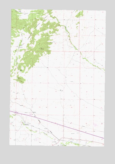
Dry Mountain, MT USGS Topographic Map
Click on map above to begin viewing in our Map Viewer.

This topographic map contains these locations and features:
Feature Name Type Latitude Longitude GNIS ID View Map
02N05W27CBCB01 WellWellN45.8938°W112.2203°813164View Map
02N05W28BBBB01 SpringSpringN45.8963°W112.2436°813179View Map
02N05W28BDDD01 SpringSpringN45.8960°W112.2331°813181View Map
02N05W28DBBB01 SpringSpringN45.8955°W112.2319°813175View Map
Blackstone (historical)LocaleN45.8760°W112.1508°1762515View Map
Bull Mountain State Wildlife Management AreaParkN45.9910°W112.1408°794194View Map
Caldwell RanchLocaleN45.9652°W112.2406°780776View Map
Dry MountainSummitN45.9641°W112.2122°782659View Map
Easter Lily MineMineN45.9369°W112.2411°782961View Map
Gillespie CreekStreamN45.9980°W112.2022°783944View Map
Gillespie RanchLocaleN45.9983°W112.2406°783945View Map
Hot SpringsSpringN45.8963°W112.2324°785085View Map
Interchange 241CrossingN45.9055°W112.2425°1762621View Map
Iris SeepSpringN45.9699°W112.1955°785310View Map
Little Pipestone CreekStreamN45.8763°W112.1756°786342View Map
Paul-McArthur Ditch Number OneCanalN45.8796°W112.1633°788708View Map
PipestoneLocaleN45.9052°W112.2203°788950View Map
PipestonePopulated PlaceN45.8966°W112.2314°1762694View Map
Pipestone CampgroundLocaleN45.8958°W112.2314°1762594View Map
Pipestone DitchCanalN45.8860°W112.1694°788951View Map
Pipestone Hot SpringsPopulated PlaceN45.8941°W112.2308°788952View Map
Pipestone Post Office (historical)Post OfficeN45.8966°W112.2314°1762557View Map
Pipestone Springs Post Office (historical)Post OfficeN45.8966°W112.2314°1762565View Map
Ringing RocksSummitN45.9433°W112.2375°789597View Map
Sage CreekStreamN45.9971°W112.2322°789910View Map
State Highway Department SandhouseLocaleN45.9094°W112.2433°794184View Map
Tippet PlacePopulated PlaceN45.9258°W112.1831°792216View Map

Note: Coordinates in the location and feature list above are referenced to NAD83 datum.


Copyright (C) 2008-2025 Ryan Niemi / Sunset Dynamics ... All Rights Reserved