TopoQuest Logo
Do you find TopoQuest useful?
Help keep TopoQuest running and adding new maps/features by donating!
Bitcoin:  19c7KJd3qBynnjoSw5npx9KScwjBe4ifkT
Litecoin:  LXs6TkuXGGXo1vDsWCkWVdjQX94eUKd6ui
Home View Maps Find Maps Find Places Resources & Links


Whitehall, Montana Topographic Map

USGS Map Title: Whitehall, MT
USGS Map MRC: 45112G1
DRG (GeoTIFF) Download: o45112g1.tif


Neighboring USGS Topographic Map Quads:


  Dry Mountain, MT  
45112H2
 

  Black Butte, MT  
45112H1
 

  Doherty Mountain, MT  
45111H8
 

  Vendome, MT  
45112G2
 

  Whitehall, MT  
45112G1
 

  Jefferson Island, MT  
45111G8
 

  Waterloo, MT  
45112F2
 

  Manhead Mountain, MT  
45112F1
 

  Pony, MT  
45111F8


Map MRC Location:

N46°
W113°
N46°
W112°
H8 H7 H6 H5 H4 H3 H2 H1
G8 G7 G6 G5 G4 G3 G2 G1
F8 F7 F6 F5 F4 F3 F2 F1
E8 E7 E6 E5 E4 E3 E2 E1
D8 D7 D6 D5 D4 D3 D2 D1
C8 C7 C6 C5 C4 C3 C2 C1
B8 B7 B6 B5 B4 B3 B2 B1
A8 A7 A6 A5 A4 A3 A2 A1
N45°
W113°
N45°
W112°

Whitehall, MT USGS 1:24K Topographic Map Preview:
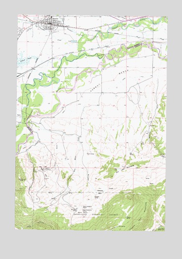
Whitehall, MT USGS Topographic Map
Click on map above to begin viewing in our Map Viewer.

This topographic map contains these locations and features:
Feature Name Type Latitude Longitude GNIS ID View Map
01N03W17ABDA01 WellWellN45.8438°W112.0264°812678View Map
01N04W03BADD01 WellWellN45.8702°W112.0867°812926View Map
01N04W04ABBA01 WellWellN45.8738°W112.1005°812968View Map
01N04W04ACCD01 WellWellN45.8705°W112.1005°812927View Map
01N04W04ADDA01 WellWellN45.8677°W112.0978°812904View Map
02N04W28CDCB01 WellWellN45.8735°W112.1131°812967View Map
Assembly of God ChurchChurchN45.8708°W112.0975°1762551View Map
Big Pipestone CreekStreamN45.8591°W112.0755°779854View Map
Bone BasinBasinN45.7602°W112.0697°780213View Map
Bone Basin CreekStreamN45.8105°W112.1150°780214View Map
Bone Basin SpringSpringN45.7628°W112.0750°780215View Map
Chicago Milwaukee and Saint Paul Crossing (historical)LocaleN45.8435°W112.1119°1762507View Map
Creek Bottom SpringSpringN45.7516°W112.0070°781874View Map
Dixon GulchValleyN45.8016°W112.0964°782422View Map
Dry LakeLakeN45.7860°W112.0401°782652View Map
Dry Lake MountainsSummitN45.7855°W112.0339°782656View Map
Era SpringSpringN45.7527°W112.0395°783217View Map
Fish CreekStreamN45.8508°W112.0511°783430View Map
Free Christian ChurchChurchN45.8702°W112.0953°1762543View Map
Gold HillSummitN45.7816°W112.1019°784059View Map
Gold Hill GulchValleyN45.7946°W112.1164°784061View Map
Guymon SpringSpringN45.7577°W112.0331°784425View Map
Jefferson Valley Baptist ChurchChurchN45.8707°W112.1092°1762552View Map
Jefferson Valley MuseumBuildingN45.8708°W112.0975°1762527View Map
John Gregory Memorial LibraryBuildingN45.8708°W112.1022°1762605View Map
Kountz (historical)LocaleN45.8527°W112.0808°1762672View Map
Kountz BridgeBridgeN45.8444°W112.0586°1762528View Map
Kountz Bridge Fishing Access SiteLocaleN45.8430°W112.0569°1744467View Map
La Casa Trailer ParkPopulated PlaceN45.8708°W112.0975°1762624View Map
Lower Gooseberry SpringSpringN45.7638°W112.0699°786672View Map
Mayflower (historical)LocaleN45.7938°W112.0019°1797490View Map
Mayflower BridgeBridgeN45.8577°W112.0139°794147View Map
Mayflower Bridge Fishing Access SiteLocaleN45.8577°W112.0158°1744464View Map
Mayflower CreekStreamN45.8499°W112.0055°1797629View Map
Mayflower GulchValleyN45.8366°W112.0089°786962View Map
Mayflower MineMineN45.7938°W112.0019°786963View Map
Mud SpringSpringN45.7950°W112.0313°787811View Map
NE SW Section 9 MineMineN45.7638°W112.1092°804384View Map
NW SE Section 31 MineMineN45.7944°W112.0244°804380View Map
NW SW Section 34 MineMineN45.7916°W112.1022°804381View Map
Parrot BenchBenchN45.8385°W112.0480°788660View Map
Parrot Castle Fishing Access SiteLocaleN45.8121°W112.1183°1744470View Map
Perry Canyon MineMineN45.7541°W112.1189°804391View Map
Piedmont SwampSwampN45.8470°W112.1248°788839View Map
Point of RocksSummitN45.7794°W112.1189°789022View Map
Pole CanyonValleyN45.7527°W112.0036°789051View Map
Renova (historical)LocaleN45.8146°W112.1211°1762654View Map
Rice Motel and Trailer CourtPopulated PlaceN45.8694°W112.0947°1762596View Map
Saint Teresa Catholic ChurchChurchN45.8716°W112.0953°1762582View Map
SE NW Section 4 MineMineN45.7624°W112.1092°804377View Map
SE SW Section 3 MineMineN45.7763°W112.0828°804382View Map
SE SW Section 5 MineMineN45.7735°W112.1230°804379View Map
Splan SpringsSpringN45.7943°W112.0667°791164View Map
SW SE Section 30 MineMineN45.8013°W112.0161°804385View Map
SW SW Section 29 MineMineN45.8041°W112.0133°804386View Map
The Church of Jesus Christ of Latter Day SaintsChurchN45.8708°W112.0975°1762550View Map
Town of WhitehallCivilN45.8710°W112.0976°2413480View Map
Trinity Methodist ChurchChurchN45.8721°W112.1017°1762581View Map
Upper Gooseberry SpringSpringN45.7616°W112.0694°792637View Map
West Mayflower MineMineN45.7952°W112.0080°794148View Map
Westphal SpringSpringN45.7693°W112.0600°793142View Map
Whestphal BasinBasinN45.7724°W112.0553°793163View Map
Whestphal CreekStreamN45.8008°W112.0725°793164View Map
WhitehallLocaleN45.8694°W112.0986°1762638View Map
WhitehallPopulated PlaceN45.8708°W112.0975°793224View Map
Whitehall AmbulanceBuildingN45.8697°W112.1013°2637918View Map
Whitehall Creek RV ParkLocaleN45.8688°W112.0903°1762595View Map
Whitehall ElementarySchoolN45.8736°W112.0975°1762529View Map
Whitehall Fire HallBuildingN45.8708°W112.1036°1762542View Map
Whitehall Medical ClinicHospitalN45.8708°W112.1017°1762588View Map
Whitehall MuseumBuildingN45.8708°W112.0975°1762526View Map
Whitehall Police DepartmentBuildingN45.8708°W112.1036°1762541View Map
Whitehall Post OfficePost OfficeN45.8706°W112.0996°1762563View Map
Whitehall Volunteer Fire DepartmentBuildingN45.8697°W112.1011°1762540View Map
Whitetail Deer CreekStreamN45.8635°W112.0705°799873View Map
Zion Lutheran ChurchChurchN45.8713°W112.1036°1762580View Map

Note: Coordinates in the location and feature list above are referenced to NAD83 datum.


Copyright (C) 2008-2025 Ryan Niemi / Sunset Dynamics ... All Rights Reserved