TopoQuest Logo
Do you find TopoQuest useful?
Help keep TopoQuest running and adding new maps/features by donating!
Bitcoin:  19c7KJd3qBynnjoSw5npx9KScwjBe4ifkT
Litecoin:  LXs6TkuXGGXo1vDsWCkWVdjQX94eUKd6ui
Home View Maps Find Maps Find Places Resources & Links


Durwards Glen, Wisconsin Topographic Map

USGS Map Title: Durwards Glen, WI
USGS Map MRC: 43089D5
DRG (GeoTIFF) Download: o43089d5.tif


Neighboring USGS Topographic Map Quads:


  Lewiston, WI  
43089E6
 

  Pine Island, WI  
43089E5
 

  Portage, WI  
43089E4
 

  Baraboo, WI  
43089D6
 

  Durwards Glen, WI  
43089D5
 

  Poynette, WI  
43089D4
 

  Sauk City, WI  
43089C6
 

  Lodi, WI  
43089C5
 

  Arlington, WI  
43089C4


Map MRC Location:

N44°
W90°
N44°
W89°
H8 H7 H6 H5 H4 H3 H2 H1
G8 G7 G6 G5 G4 G3 G2 G1
F8 F7 F6 F5 F4 F3 F2 F1
E8 E7 E6 E5 E4 E3 E2 E1
D8 D7 D6 D5 D4 D3 D2 D1
C8 C7 C6 C5 C4 C3 C2 C1
B8 B7 B6 B5 B4 B3 B2 B1
A8 A7 A6 A5 A4 A3 A2 A1
N43°
W90°
N43°
W89°

Durwards Glen, WI USGS 1:24K Topographic Map Preview:
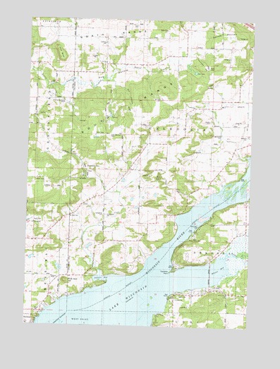
Durwards Glen, WI USGS Topographic Map
Click on map above to begin viewing in our Map Viewer.

This topographic map contains these locations and features:
Feature Name Type Latitude Longitude GNIS ID View Map
Alloa School (historical)SchoolN43.4508°W89.5171°1842925View Map
American Ukranian CampLocaleN43.4661°W89.6051°1560826View Map
Caledonia CemeteryCemeteryN43.4905°W89.5818°1562512View Map
Caledonia ChurchChurchN43.4644°W89.5323°1562513View Map
Caledonia Elementary SchoolSchoolN43.4653°W89.5168°1562514View Map
Camp Rest ParkParkN43.4158°W89.5287°1562651View Map
Cascade MountainSummitN43.4930°W89.5187°1562759View Map
Cat HollowValleyN43.4728°W89.5768°1562798View Map
Dekorra ChurchChurchN43.3883°W89.5118°1563870View Map
Dekorra Lutheran CemeteryCemeteryN43.3872°W89.5390°1563869View Map
Devils Head Golf CourseLocaleN43.4172°W89.6187°1581205View Map
Dog HollowValleyN43.4712°W89.6142°1564032View Map
Dog Hollow School (historical)SchoolN43.4805°W89.5723°1842952View Map
Durwards GlenPopulated PlaceN43.4386°W89.5915°1577579View Map
Durwards Glen School (historical)SchoolN43.4272°W89.5871°1842953View Map
Evangelical CemeteryCemeteryN43.4203°W89.5821°1564720View Map
Happy Hollow ParkParkN43.4114°W89.5329°1842975View Map
Hill CemeteryCemeteryN43.3953°W89.6207°1566411View Map
Ikey School (historical)SchoolN43.4819°W89.6240°1846856View Map
Indian Farm CemeteryCemeteryN43.4200°W89.5804°1566913View Map
Indian Farm School (historical)SchoolN43.4403°W89.5676°1842980View Map
Lake Wisconsin Census Designated PlaceCensusN43.3782°W89.5762°2393088View Map
Lincoln School (historical)SchoolN43.4172°W89.5015°1842985View Map
Little Church (historical)SchoolN43.4197°W89.6010°1846863View Map
Lost LakeLakeN43.4786°W89.5320°1568679View Map
Lost Lake State Natural AreaParkN43.4786°W89.5321°2055082View Map
McDonald CemeteryCemeteryN43.4530°W89.5168°1569201View Map
Merrimac Community SchoolSchoolN43.3754°W89.6240°1846871View Map
Methodist CemeteryCemeteryN43.4525°W89.5023°1569385View Map
Owen Memorial ParkParkN43.4530°W89.5790°1570962View Map
Owls Head HillSummitN43.3933°W89.6029°1570969View Map
Petras RavineValleyN43.4340°W89.5527°1571274View Map
Pine BluffCliffN43.4858°W89.6073°1571418View Map
Prentice CreekStreamN43.3953°W89.5829°1571916View Map
Rowan CreekStreamN43.4028°W89.5135°1572687View Map
Saint Camillus Novitiate CemeteryCemeteryN43.4378°W89.5923°1955182View Map
Saint Johns CemeteryCemeteryN43.4191°W89.6015°1573072View Map
Saint Pauls CemeteryCemeteryN43.4830°W89.5826°1955186View Map
Saint Pauls ChurchChurchN43.4825°W89.5818°1573493View Map
Shanks CemeteryCemeteryN43.4589°W89.5232°1573962View Map
Stoners BayBayN43.3936°W89.5826°1574936View Map
Tipperary PointCapeN43.3972°W89.5443°1575470View Map
Town of CaledoniaCivilN43.4773°W89.5351°1582903View Map
Townhall HillSummitN43.4811°W89.5273°1575540View Map
Whalen BayBayN43.3967°W89.5190°1576594View Map

Note: Coordinates in the location and feature list above are referenced to NAD83 datum.


Copyright (C) 2008-2024 Ryan Niemi / Sunset Dynamics ... All Rights Reserved