TopoQuest Logo
Do you find TopoQuest useful?
Help keep TopoQuest running and adding new maps/features by donating!
Bitcoin:  19c7KJd3qBynnjoSw5npx9KScwjBe4ifkT
Litecoin:  LXs6TkuXGGXo1vDsWCkWVdjQX94eUKd6ui
Home View Maps Find Maps Find Places Resources & Links


Sauk City, Wisconsin Topographic Map

USGS Map Title: Sauk City, WI
USGS Map MRC: 43089C6
DRG (GeoTIFF) Download: o43089c6.tif


Neighboring USGS Topographic Map Quads:


  North Freedom, WI  
43089D7
 

  Baraboo, WI  
43089D6
 

  Durwards Glen, WI  
43089D5
 

  Sauk Prairie, WI  
43089C7
 

  Sauk City, WI  
43089C6
 

  Lodi, WI  
43089C5
 

  Mazomanie, WI  
43089B7
 

  Black Earth, WI  
43089B6
 

  Springfield Corners, WI  
43089B5


Map MRC Location:

N44°
W90°
N44°
W89°
H8 H7 H6 H5 H4 H3 H2 H1
G8 G7 G6 G5 G4 G3 G2 G1
F8 F7 F6 F5 F4 F3 F2 F1
E8 E7 E6 E5 E4 E3 E2 E1
D8 D7 D6 D5 D4 D3 D2 D1
C8 C7 C6 C5 C4 C3 C2 C1
B8 B7 B6 B5 B4 B3 B2 B1
A8 A7 A6 A5 A4 A3 A2 A1
N43°
W90°
N43°
W89°

Sauk City, WI USGS 1:24K Topographic Map Preview:
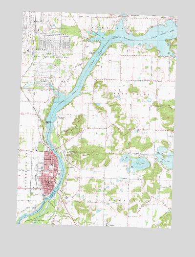
Sauk City, WI USGS Topographic Map
Click on map above to begin viewing in our Map Viewer.

This topographic map contains these locations and features:
Feature Name Type Latitude Longitude GNIS ID View Map
Alder PondLakeN43.3066°W89.6562°1560745View Map
Alice Graf ParkParkN43.2897°W89.7190°1846794View Map
Black Hawk RidgeRidgeN43.3064°W89.7040°1561865View Map
Calvary Baptist ChurchChurchN43.2780°W89.7201°1846811View Map
Camp CarlsonLocaleN43.2833°W89.7090°1562588View Map
Concordia United Methodist ChurchChurchN43.2917°W89.7254°1846820View Map
Derleth ParkParkN43.2792°W89.7171°1563912View Map
Firemans ParkParkN43.2933°W89.7229°1846830View Map
First Presbyterian ChurchChurchN43.2900°W89.7251°1846835View Map
First Reformed Church (historical)ChurchN43.2769°W89.7254°1846838View Map
First United ChurchChurchN43.2769°W89.7254°1846839View Map
Fish LakeLakeN43.2875°W89.6522°1564994View Map
Fish Lake County ParkParkN43.2861°W89.6612°1565006View Map
Free Thinkers ParkParkN43.2764°W89.7246°1565289View Map
Freie Gemeinde HallBuildingN43.2747°W89.7235°1846843View Map
Gannons Landing Strip (historical)AirportN43.3008°W89.6268°1842967View Map
Goose Egg HillSummitN43.3586°W89.6276°1565645View Map
Grand Avenue Elementary SchoolSchoolN43.2852°W89.7230°1565710View Map
Hahn House MuseumBuildingN43.2736°W89.7204°1846849View Map
Junge ParkParkN43.2786°W89.7373°1846860View Map
Kingston CemeteryCemeteryN43.3555°W89.6998°1567513View Map
Lake Wisconsin Country ClubLocaleN43.3130°W89.7190°1581254View Map
Madison Street SchoolSchoolN43.2728°W89.7260°1568884View Map
Marion ParkParkN43.2844°W89.7215°1569047View Map
Mazomanie State Wildlife AreaParkN43.2550°W89.7326°1569154View Map
Middle SchoolSchoolN43.2811°W89.7321°1569435View Map
Moon ValleyPopulated PlaceN43.3703°W89.6726°1569698View Map
Mosquito IslandIslandN43.2711°W89.7173°1842567View Map
Mud LakeLakeN43.2889°W89.6643°1569910View Map
Pine Vista Mobile Home ParkPopulated PlaceN43.3025°W89.7175°2612469View Map
Prairie du SacPopulated PlaceN43.2869°W89.7240°1571875View Map
Prairie Du Sac 1907c189 DamDamN43.3100°W89.7251°1791716View Map
Prairie du Sac CemeteryCemeteryN43.2880°W89.7301°1846899View Map
Prairie du Sac Fire DepartmentBuildingN43.2960°W89.7398°2697852View Map
Prairie du Sac Post OfficePost OfficeN43.2905°W89.7229°1846900View Map
Round Top HillSummitN43.2908°W89.7098°1572685View Map
Ryan PondLakeN43.3260°W89.6706°1572768View Map
Saint Aloysius Catholic ChurchChurchN43.2814°W89.7257°1846913View Map
Saint Aloysius CemeteryCemeteryN43.2674°W89.7381°1572825View Map
Saint Aloysius SchoolSchoolN43.2816°W89.7267°1572823View Map
Saint James Evangelical Lutheran ChurchChurchN43.2905°W89.7243°1846915View Map
Saint Johns Evangelical Lutheran ChurchChurchN43.2828°W89.7218°1846920View Map
Saint Norberts German Catholic ChurchChurchN43.2505°W89.6771°1842663View Map
Sauk CityPopulated PlaceN43.2708°W89.7221°1573732View Map
Sauk City CemeteryCemeteryN43.2686°W89.7382°1846935View Map
Sauk City Fire DepartmentBuildingN43.2738°W89.7257°2698008View Map
Sauk City Post OfficePost OfficeN43.2724°W89.7214°1846936View Map
Sauk City Public LibraryBuildingN43.2750°W89.7210°1846937View Map
Sauk Prairie Ambulance AssociationBuildingN43.2817°W89.7207°2698368View Map
Sauk Prairie Evangelical Free ChurchChurchN43.2828°W89.7348°1846941View Map
Sauk Prairie High SchoolSchoolN43.2834°W89.7308°1846942View Map
Sauk Prairie Middle SchoolSchoolN43.2811°W89.7323°1846944View Map
Sauk Prairie Police DepartmentBuildingN43.2724°W89.7207°2759752View Map
Spruce Street Elementary SchoolSchoolN43.2733°W89.7304°1574741View Map
Sugarloaf HillSummitN43.2925°W89.6921°1575038View Map
Summer Oaks County ParkParkN43.3503°W89.6946°1575051View Map
Thoelke CemeteryCemeteryN43.3430°W89.7271°1575366View Map
Town of West PointCivilN43.3283°W89.6420°1584414View Map
Tripp Memorial Library and MuseumBuildingN43.2914°W89.7215°1846965View Map
Village of MerrimacCivilN43.3741°W89.6273°1583704View Map
Village of Prairie du SacCivilN43.2898°W89.7247°1583973View Map
Village of Sauk CityCivilN43.2722°W89.7306°1584102View Map
Village ParkParkN43.2994°W89.7282°1576098View Map
Wiegands BayBayN43.3614°W89.6887°1576718View Map

Note: Coordinates in the location and feature list above are referenced to NAD83 datum.


Copyright (C) 2008-2025 Ryan Niemi / Sunset Dynamics ... All Rights Reserved