TopoQuest Logo
Do you find TopoQuest useful?
Help keep TopoQuest running and adding new maps/features by donating!
Bitcoin:  19c7KJd3qBynnjoSw5npx9KScwjBe4ifkT
Litecoin:  LXs6TkuXGGXo1vDsWCkWVdjQX94eUKd6ui
Home View Maps Find Maps Find Places Resources & Links


Buchanan, Virginia Topographic Map

USGS Map Title: Buchanan, VA
USGS Map MRC: 37079E6
DRG (GeoTIFF) Download: o37079e6.tif


Neighboring USGS Topographic Map Quads:


  Eagle Rock, VA  
37079F7
 

  Sugarloaf Mountain, VA  
37079F6
 

  Natural Bridge, VA  
37079F5
 

  Salisbury, VA  
37079E7
 

  Buchanan, VA  
37079E6
 

  Arnold Valley, VA  
37079E5
 

  Villamont, VA  
37079D7
 

  Montvale, VA  
37079D6
 

  Peaks of Otter, VA  
37079D5


Map MRC Location:

N38°
W80°
N38°
W79°
H8 H7 H6 H5 H4 H3 H2 H1
G8 G7 G6 G5 G4 G3 G2 G1
F8 F7 F6 F5 F4 F3 F2 F1
E8 E7 E6 E5 E4 E3 E2 E1
D8 D7 D6 D5 D4 D3 D2 D1
C8 C7 C6 C5 C4 C3 C2 C1
B8 B7 B6 B5 B4 B3 B2 B1
A8 A7 A6 A5 A4 A3 A2 A1
N37°
W80°
N37°
W79°

Buchanan, VA USGS 1:24K Topographic Map Preview:
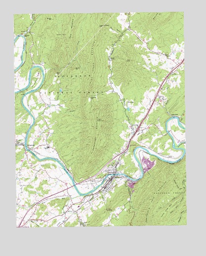
Buchanan, VA USGS Topographic Map
Click on map above to begin viewing in our Map Viewer.

This topographic map contains these locations and features:
Feature Name Type Latitude Longitude GNIS ID View Map
Assembly of God ChurchChurchN37.5265°W79.6942°1481351View Map
Back CreekStreamN37.5918°W79.7287°1481371View Map
Back Creek MountainSummitN37.5829°W79.6931°1492498View Map
Bearwallow CreekStreamN37.5276°W79.6667°1481553View Map
Brushy MountainSummitN37.6215°W79.7214°1482069View Map
BuchananPopulated PlaceN37.5274°W79.6798°1492652View Map
Buchanan DistrictCivilN37.5397°W79.6978°1927119View Map
Buchanan Elementary SchoolSchoolN37.5122°W79.7040°1674379View Map
Buchanan High SchoolSchoolN37.5276°W79.6809°1674380View Map
Buchanan Post OfficePost OfficeN37.5271°W79.6801°1674384View Map
Buchanan Presbyterian ChurchChurchN37.5257°W79.6825°1674378View Map
Buchanan Quarry Number 1MineN37.5239°W79.6664°2724860View Map
Buchanan Volunteer Fire and Rescue Company 3BuildingN37.5268°W79.6805°2075552View Map
Calvin School (historical)SchoolN37.5971°W79.7362°1674387View Map
Cartmell GapGapN37.5751°W79.6942°1482355View Map
Cedar Bluff ChurchChurchN37.5890°W79.6339°1482392View Map
Cherry Orchard GapGapN37.6171°W79.6867°1482460View Map
Clifton School (historical)SchoolN37.5651°W79.7289°1674388View Map
Concord Fire DepartmentSchoolN37.5886°W79.6433°2086335View Map
Concord Volunteer Rescue SquadSchoolN37.5839°W79.6422°2086363View Map
Cove Mountain ShelterLocaleN37.5115°W79.6506°1488775View Map
David RunStreamN37.5340°W79.7148°1482927View Map
DillonPopulated PlaceN37.5396°W79.6378°1492867View Map
Dry RunStreamN37.5226°W79.6892°1483140View Map
Fairview CemeteryCemeteryN37.5321°W79.6842°1483328View Map
First Baptist ChurchChurchN37.5235°W79.6853°1674377View Map
First Baptist ChurchChurchN37.5274°W79.6800°1674383View Map
Garsts Store (historical)LocaleN37.5043°W79.7403°1674391View Map
Grace ChurchChurchN37.5996°W79.6378°1483728View Map
Grassy Island (historical)IslandN37.5999°W79.7425°1674385View Map
Green SpurSummitN37.6137°W79.7178°1493031View Map
GreyledgePopulated PlaceN37.5724°W79.6664°1493040View Map
Hickory Hollow BranchStreamN37.6121°W79.7431°1484065View Map
Horseshoe BendBendN37.5876°W79.7331°1484230View Map
Indian RockLocaleN37.5640°W79.6320°1484334View Map
Indian Rock ChurchChurchN37.5749°W79.6437°1484335View Map
Interchange 167CrossingN37.5468°W79.6670°1488789View Map
Interchange 168CrossingN37.5568°W79.6595°1488788View Map
Jackson ChurchChurchN37.5501°W79.7481°1484387View Map
James River High SchoolSchoolN37.5469°W79.7262°1498396View Map
Jennings CreekStreamN37.5471°W79.6328°1484413View Map
Karnes SpringSpringN37.5984°W79.6793°1484523View Map
Laurel RunStreamN37.5076°W79.7139°1484724View Map
Little Cove CreekStreamN37.5185°W79.6264°1484886View Map
Little Cove MountainRidgeN37.5074°W79.6406°1484887View Map
Long RunStreamN37.5165°W79.7081°1485064View Map
Looney CreekStreamN37.5179°W79.7023°1485084View Map
Mays CemeteryCemeteryN37.5960°W79.7300°1485240View Map
McFalls Ridge TrailTrailN37.5037°W79.6364°1488676View Map
Middle CreekStreamN37.5268°W79.6250°1485366View Map
Mount Beulah Church (historical)ChurchN37.5996°W79.7375°1674386View Map
Mount Carmel ChurchChurchN37.6146°W79.7398°1485578View Map
Mount Joy ChurchChurchN37.6154°W79.6648°1485596View Map
Mount Zion ChurchChurchN37.5740°W79.6412°1485663View Map
Penn BranchStreamN37.5632°W79.7350°1486132View Map
Ponton CemeteryCemeteryN37.5840°W79.6348°1486334View Map
Purgatory CreekStreamN37.5307°W79.6742°1486457View Map
Purgatory MountainSummitN37.5624°W79.6884°1486458View Map
Purgatory Mountain LookoutTowerN37.5624°W79.6889°1488787View Map
Renick RunStreamN37.5635°W79.6339°1486569View Map
Rich HillSummitN37.5899°W79.7189°1486584View Map
Round MountainSummitN37.5926°W79.7048°1486791View Map
Saint Marks ChurchChurchN37.5490°W79.7489°1486867View Map
Sales BranchStreamN37.6129°W79.6692°1486893View Map
Saltpetre CaveLocaleN37.6135°W79.7420°1486912View Map
Shafer CemeteryCemeteryN37.5304°W79.7478°1487021View Map
Short HillsRangeN37.6235°W79.6425°1487219View Map
Spreading Spring BranchStreamN37.5487°W79.7428°1487443View Map
SpringwoodPopulated PlaceN37.5490°W79.7448°1487475View Map
Springwood Airstrip GliderportAirportN37.5540°W79.7498°1498604View Map
Springwood Post Office (historical)Post OfficeN37.5468°W79.7434°1674390View Map
Springwood Truss BridgeBridgeN37.5474°W79.7420°1674389View Map
The GorgeGapN37.5085°W79.6817°1487827View Map
The KnobSummitN37.5971°W79.6642°1487831View Map
Town of BuchananCivilN37.5211°W79.6895°2390759View Map
Trinity Episcopal ChurchChurchN37.5265°W79.6809°1674382View Map
Trinity Methodist Episcopal Church SouthChurchN37.5265°W79.6814°1674381View Map
Virginia ChurchChurchN37.5012°W79.7006°1488135View Map

Note: Coordinates in the location and feature list above are referenced to NAD83 datum.


Copyright (C) 2008-2024 Ryan Niemi / Sunset Dynamics ... All Rights Reserved