TopoQuest Logo
Do you find TopoQuest useful?
Help keep TopoQuest running and adding new maps/features by donating!
Bitcoin:  19c7KJd3qBynnjoSw5npx9KScwjBe4ifkT
Litecoin:  LXs6TkuXGGXo1vDsWCkWVdjQX94eUKd6ui
Home View Maps Find Maps Find Places Resources & Links


Eagletown, Oklahoma Topographic Map

USGS Map Title: Eagletown, OK
USGS Map MRC: 34094A5
DRG (GeoTIFF) Download: o34094a5.tif


Neighboring USGS Topographic Map Quads:


  Stephens Gap, OK  
34094B6
 

  Tablerville, OK  
34094B5
 

  De Queen NW, AR  
34094B4
 

  Broken Bow, OK  
34094A6
 

  Eagletown, OK  
34094A5
 

  Chapel Hill, AR  
34094A4
 

  Shults, OK  
33094H6
 

  Goodwater, OK  
33094H5
 

  Cerrogordo, AR  
33094H4


Map MRC Location:

N35°
W95°
N35°
W94°
H8 H7 H6 H5 H4 H3 H2 H1
G8 G7 G6 G5 G4 G3 G2 G1
F8 F7 F6 F5 F4 F3 F2 F1
E8 E7 E6 E5 E4 E3 E2 E1
D8 D7 D6 D5 D4 D3 D2 D1
C8 C7 C6 C5 C4 C3 C2 C1
B8 B7 B6 B5 B4 B3 B2 B1
A8 A7 A6 A5 A4 A3 A2 A1
N34°
W95°
N34°
W94°

Eagletown, OK USGS 1:24K Topographic Map Preview:
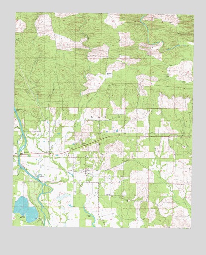
Eagletown, OK USGS Topographic Map
Click on map above to begin viewing in our Map Viewer.

This topographic map contains these locations and features:
Feature Name Type Latitude Longitude GNIS ID View Map
Buck Creek LandingPopulated PlaceN34.0265°W94.5116°1100243View Map
Camp BranchStreamN34.0657°W94.5316°1090834View Map
Cooper CreekStreamN34.0579°W94.6199°1091672View Map
Death CreekStreamN34.0607°W94.5805°1091984View Map
EagletownPopulated PlaceN34.0343°W94.5749°1092337View Map
Eagletown CemeteryCemeteryN34.0495°W94.5785°1092338View Map
Eagletown Census Designated PlaceCensusN34.0416°W94.5700°2629916View Map
Eagletown Elementary SchoolSchoolN34.0419°W94.5750°1790633View Map
Eagletown High SchoolSchoolN34.0419°W94.5750°1790322View Map
Eagletown Post OfficePost OfficeN34.0444°W94.5896°1813914View Map
Eagletown Volunteer Fire DepartmentBuildingN34.0424°W94.5831°2657076View Map
Grassy LakeLakeN34.0078°W94.5709°1101437View Map
Lick CreekStreamN34.0659°W94.6016°1094624View Map
Lick CreekStreamN34.0412°W94.5980°1094626View Map
Liksuklo CreekStreamN34.0257°W94.6027°1094636View Map
Mountain Fork CemeteryCemeteryN34.0189°W94.5458°2712256View Map
Mountain Fork ChurchChurchN34.0187°W94.5480°1095642View Map
Oknoname 089013 DamDamN34.0201°W94.5885°1757701View Map
Oknoname 089013 ReservoirReservoirN34.0178°W94.5897°1757702View Map
Presbyterian FallsFallsN34.0696°W94.6241°1096922View Map
Racetrack PrairieFlatN34.0893°W94.5194°1097013View Map
Saint Paul ChurchChurchN34.0101°W94.5685°1777416View Map
Tonka CemeteryCemeteryN34.0196°W94.5563°1098939View Map
Winship PrairieFlatN34.0904°W94.5583°1099920View Map

Note: Coordinates in the location and feature list above are referenced to NAD83 datum.


Copyright (C) 2008-2025 Ryan Niemi / Sunset Dynamics ... All Rights Reserved