TopoQuest Logo
Do you find TopoQuest useful?
Help keep TopoQuest running and adding new maps/features by donating!
Bitcoin:  19c7KJd3qBynnjoSw5npx9KScwjBe4ifkT
Litecoin:  LXs6TkuXGGXo1vDsWCkWVdjQX94eUKd6ui
Home View Maps Find Maps Find Places Resources & Links


Stephens Gap, Oklahoma Topographic Map

USGS Map Title: Stephens Gap, OK
USGS Map MRC: 34094B6
DRG (GeoTIFF) Download: o34094b6.tif


Neighboring USGS Topographic Map Quads:


  Bethel, OK  
34094C7
 

  Hee Creek, OK  
34094C6
 

  Big Hudson Creek, OK  
34094C5
 

  Old Glory Mountain, OK  
34094B7
 

  Stephens Gap, OK  
34094B6
 

  Tablerville, OK  
34094B5
 

  Steel Junction, OK  
34094A7
 

  Broken Bow, OK  
34094A6
 

  Eagletown, OK  
34094A5


Map MRC Location:

N35°
W95°
N35°
W94°
H8 H7 H6 H5 H4 H3 H2 H1
G8 G7 G6 G5 G4 G3 G2 G1
F8 F7 F6 F5 F4 F3 F2 F1
E8 E7 E6 E5 E4 E3 E2 E1
D8 D7 D6 D5 D4 D3 D2 D1
C8 C7 C6 C5 C4 C3 C2 C1
B8 B7 B6 B5 B4 B3 B2 B1
A8 A7 A6 A5 A4 A3 A2 A1
N34°
W95°
N34°
W94°

Stephens Gap, OK USGS 1:24K Topographic Map Preview:
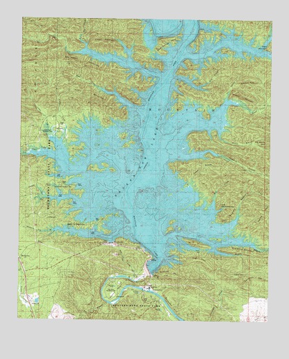
Stephens Gap, OK USGS Topographic Map
Click on map above to begin viewing in our Map Viewer.

This topographic map contains these locations and features:
Feature Name Type Latitude Longitude GNIS ID View Map
Arnet GapGapN34.1546°W94.6577°1089705View Map
Ashford PeakSummitN34.2254°W94.6383°1089731View Map
Beaver CreekStreamN34.1329°W94.6769°1089934View Map
Beaver Lodge Nature TrailTrailN34.1493°W94.6983°1777840View Map
Beavers BendBendN34.1384°W94.7019°1089947View Map
Beavers Bend State ParkParkN34.1312°W94.6899°1089948View Map
Bee BranchStreamN34.1326°W94.7052°1089960View Map
Bee CreekStreamN34.2232°W94.6808°1089964View Map
Bee Creek MountainSummitN34.2279°W94.7094°1089965View Map
Biggam CreekStreamN34.1551°W94.6830°1090136View Map
Boji CreekStreamN34.1621°W94.6577°1090367View Map
Broken Bow DamDamN34.1459°W94.6819°1751398View Map
Broken Bow LakeReservoirN34.2118°W94.6844°1101902View Map
Brushy MountainSummitN34.2196°W94.6394°1090583View Map
Burke BranchStreamN34.1723°W94.6933°1090713View Map
Calahan LakeLakeN34.2098°W94.6802°1090805View Map
Candy MountainSummitN34.1684°W94.6263°1101962View Map
Carnasaw MountainSummitN34.1446°W94.6377°1101963View Map
Carper MountainSummitN34.2404°W94.7061°1090990View Map
Carson CreekStreamN34.1651°W94.6938°1090998View Map
Carson Creek Recreation AreaParkN34.1801°W94.7286°1777845View Map
Cat HollowValleyN34.2173°W94.6472°1091034View Map
Cedar CreekStreamN34.1837°W94.6933°1091088View Map
Cedar Creek Recreation AreaParkN34.2032°W94.7202°1777846View Map
County District 2CivilN34.1849°W94.7226°2418889View Map
Devils BackboneRidgeN34.1409°W94.6908°1092053View Map
Dry BranchStreamN34.2265°W94.6758°1092209View Map
Dyer CreekStreamN34.2107°W94.6869°1092091View Map
Dyer MountainSummitN34.2187°W94.7238°1092092View Map
Egypt CreekStreamN34.1962°W94.6872°1092502View Map
Fivemile HollowValleyN34.1929°W94.6697°1092862View Map
Grapevine MountainSummitN34.1543°W94.6424°1093324View Map
Hickory BranchStreamN34.1568°W94.6519°1093696View Map
High PeakSummitN34.1504°W94.6649°1093736View Map
Hochatown State ParkParkN34.1848°W94.7419°1777847View Map
Lamas BranchStreamN34.1529°W94.6822°1094489View Map
Little Round MountainSummitN34.1729°W94.6505°1094820View Map
Lower Cedar CreekStreamN34.1901°W94.7305°1095031View Map
Nancy BranchStreamN34.2079°W94.6549°1095742View Map
North Bee CreekStreamN34.2365°W94.7163°1095912View Map
North Cedar CreekStreamN34.1957°W94.7294°1095929View Map
North Otter CreekStreamN34.2373°W94.6316°1101971View Map
Otter CreekStreamN34.2371°W94.6697°1101972View Map
Rattlesnake BluffCliffN34.1346°W94.6763°1097055View Map
River Bend Recreation AreaParkN34.1373°W94.7041°1777842View Map
Rockpile MountainRangeN34.1454°W94.6752°1777839View Map
Rookpile MountainSummitN34.1443°W94.6766°1097406View Map
Rough BranchStreamN34.2493°W94.6863°1097476View Map
Round MountainSummitN34.1676°W94.6485°1097493View Map
Sand Springs BendBendN34.2459°W94.6680°1097784View Map
Stephens CreekStreamN34.1640°W94.6927°1098526View Map
Stephens GapPopulated PlaceN34.1573°W94.7002°1777841View Map
Stephens Gap BranchStreamN34.1621°W94.7333°1777844View Map
Stephens Gap Recreation AreaParkN34.1646°W94.7216°1777843View Map
Walford CreekStreamN34.1612°W94.6616°1099297View Map

Note: Coordinates in the location and feature list above are referenced to NAD83 datum.


Copyright (C) 2008-2025 Ryan Niemi / Sunset Dynamics ... All Rights Reserved