TopoQuest Logo
Do you find TopoQuest useful?
Help keep TopoQuest running and adding new maps/features by donating!
Bitcoin:  19c7KJd3qBynnjoSw5npx9KScwjBe4ifkT
Litecoin:  LXs6TkuXGGXo1vDsWCkWVdjQX94eUKd6ui
Home View Maps Find Maps Find Places Resources & Links


Broken Bow, Oklahoma Topographic Map

USGS Map Title: Broken Bow, OK
USGS Map MRC: 34094A6
DRG (GeoTIFF) Download: o34094a6.tif


Neighboring USGS Topographic Map Quads:


  Old Glory Mountain, OK  
34094B7
 

  Stephens Gap, OK  
34094B6
 

  Tablerville, OK  
34094B5
 

  Steel Junction, OK  
34094A7
 

  Broken Bow, OK  
34094A6
 

  Eagletown, OK  
34094A5
 

  Idabel, OK  
33094H7
 

  Shults, OK  
33094H6
 

  Goodwater, OK  
33094H5


Map MRC Location:

N35°
W95°
N35°
W94°
H8 H7 H6 H5 H4 H3 H2 H1
G8 G7 G6 G5 G4 G3 G2 G1
F8 F7 F6 F5 F4 F3 F2 F1
E8 E7 E6 E5 E4 E3 E2 E1
D8 D7 D6 D5 D4 D3 D2 D1
C8 C7 C6 C5 C4 C3 C2 C1
B8 B7 B6 B5 B4 B3 B2 B1
A8 A7 A6 A5 A4 A3 A2 A1
N34°
W95°
N34°
W94°

Broken Bow, OK USGS 1:24K Topographic Map Preview:
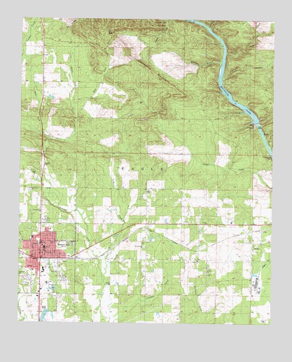
Broken Bow, OK USGS Topographic Map
Click on map above to begin viewing in our Map Viewer.

This topographic map contains these locations and features:
Feature Name Type Latitude Longitude GNIS ID View Map
Bennett Elementary SchoolSchoolN34.0325°W94.7399°1747180View Map
Broken Arrow Police DepartmentBuildingN34.0292°W94.7373°2757684View Map
Broken BowPopulated PlaceN34.0293°W94.7391°1090514View Map
Broken Bow CemeteryCemeteryN34.0108°W94.7322°2712251View Map
Broken Bow City LakeReservoirN34.0134°W94.7302°1756121View Map
Broken Bow City Lake DamDamN34.0134°W94.7302°1756120View Map
Broken Bow DivisionCivilN34.0600°W94.7026°1937655View Map
Broken Bow Fire Department Station 1BuildingN34.0267°W94.7374°2657046View Map
Broken Bow Fire Department Station 2BuildingN34.0187°W94.7382°2657231View Map
Broken Bow High SchoolSchoolN34.0163°W94.7388°2713088View Map
Broken Bow Independent School DistrictCivilN34.0309°W94.7377°1803920View Map
Broken Bow Lookout TowerTowerN34.0473°W94.7385°1101992View Map
Broken Bow Post OfficePost OfficeN34.0310°W94.7376°1813345View Map
Carnasaw CreekStreamN34.1204°W94.6563°1090976View Map
Church of ChristChurchN34.0246°W94.7397°1782624View Map
City of Broken BowCivilN34.0278°W94.7420°2409915View Map
Coon CreekStreamN34.0187°W94.7074°1091634View Map
CraigLocaleN34.0384°W94.6288°1747184View Map
Crown Hill CemeteryCemeteryN34.0193°W94.7491°1091863View Map
Dierks Elementary SchoolSchoolN34.0214°W94.7428°1747181View Map
East Fork Yanubbee CreekStreamN34.0890°W94.7238°1092399View Map
Faith Christian CenterChurchN34.0423°W94.7360°1782625View Map
First Baptist ChurchChurchN34.0315°W94.7388°1782626View Map
First Christian ChurchChurchN34.0298°W94.7372°1782627View Map
Fish Fry CreekStreamN34.0882°W94.6385°1092837View Map
Good News FellowshipChurchN34.0115°W94.7341°1782628View Map
Goodwater ChurchChurchN34.0315°W94.6888°1093256View Map
Horsepen BranchStreamN34.1082°W94.6508°1093947View Map
Horseshoe MountainSummitN34.1073°W94.6919°1093965View Map
Lighthouse Christian CenterChurchN34.0226°W94.7485°1782629View Map
McCurtain County Emergency Medical Services Broken Bow SubstationBuildingN34.0367°W94.7399°2695957View Map
Middle Fork Yanubbee CreekStreamN34.0754°W94.7360°1095357View Map
North Highway ChurchChurchN34.0462°W94.7327°1747179View Map
Oak Grove ChurchChurchN34.0262°W94.6622°1096098View Map
Oka Achukma CemeteryCemeteryN34.0328°W94.6880°2712258View Map
Oka Achukma Presbyterian ChurchChurchN34.0315°W94.6891°1747182View Map
Oklahoma Forestry Services Southeastern AreaBuildingN34.0496°W94.7392°2657111View Map
Oknoname 089006 DamDamN34.0034°W94.7435°1756108View Map
Oknoname 089006 ReservoirReservoirN34.0028°W94.7428°1756109View Map
Presbyterian ChurchChurchN34.0257°W94.7408°1782630View Map
Rector Johnson Middle SchoolSchoolN34.0164°W94.7364°2713089View Map
Rough BranchStreamN34.1001°W94.6516°1097475View Map
Saint Matthew ChurchChurchN34.0218°W94.6574°1097632View Map
Slate BranchStreamN34.1115°W94.6488°1098112View Map
South Park Shopping CenterLocaleN34.0251°W94.7402°1763788View Map
Sweet Home ChurchChurchN34.0548°W94.7447°1747178View Map
TinerPopulated PlaceN34.0412°W94.6335°1747183View Map
United Pentecostal ChurchChurchN34.0276°W94.7422°1782631View Map
West Fork Yanubbee CreekStreamN34.0754°W94.7360°1099563View Map

Note: Coordinates in the location and feature list above are referenced to NAD83 datum.


Copyright (C) 2008-2025 Ryan Niemi / Sunset Dynamics ... All Rights Reserved