TopoQuest Logo
Do you find TopoQuest useful?
Help keep TopoQuest running and adding new maps/features by donating!
Bitcoin:  19c7KJd3qBynnjoSw5npx9KScwjBe4ifkT
Litecoin:  LXs6TkuXGGXo1vDsWCkWVdjQX94eUKd6ui
Home View Maps Find Maps Find Places Resources & Links


East Gavilan Canyon, New Mexico Topographic Map

USGS Map Title: East Gavilan Canyon, NM
USGS Map MRC: 36106F3
DRG (GeoTIFF) Download: o36106f3.tif


Neighboring USGS Topographic Map Quads:


  Brazos Peak, NM  
36106G4
 

  Lagunitas Creek, NM  
36106G3
 

  Broke Off Mountain, NM  
36106G2
 

  Penasco Amarillo, NM  
36106F4
 

  East Gavilan Canyon, NM  
36106F3
 

  Burned Mountain, NM  
36106F2
 

  Cebolla, NM  
36106E4
 

  Canjilon Mountain, NM  
36106E3
 

  Canon Plaza, NM  
36106E2


Map MRC Location:

N37°
W107°
N37°
W106°
H8 H7 H6 H5 H4 H3 H2 H1
G8 G7 G6 G5 G4 G3 G2 G1
F8 F7 F6 F5 F4 F3 F2 F1
E8 E7 E6 E5 E4 E3 E2 E1
D8 D7 D6 D5 D4 D3 D2 D1
C8 C7 C6 C5 C4 C3 C2 C1
B8 B7 B6 B5 B4 B3 B2 B1
A8 A7 A6 A5 A4 A3 A2 A1
N36°
W107°
N36°
W106°

East Gavilan Canyon, NM USGS 1:24K Topographic Map Preview:
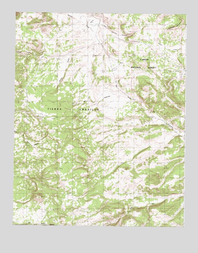
East Gavilan Canyon, NM USGS Topographic Map
Click on map above to begin viewing in our Map Viewer.

This topographic map contains these locations and features:
Feature Name Type Latitude Longitude GNIS ID View Map
Cerro SaragateSummitN36.6417°W106.3561°912556View Map
Chavez TankReservoirN36.7381°W106.3018°914129View Map
Crowther Cow CampPopulated PlaceN36.7228°W106.3423°912620View Map
East Gavilan CanyonValleyN36.7433°W106.3122°1782020View Map
Gavilon TankReservoirN36.7428°W106.2789°914205View Map
Headstone MineMineN36.7000°W106.2839°939971View Map
Hidden Treasure MineMineN36.7000°W106.2839°939972View Map
Hooker SawmillLocaleN36.6967°W106.3314°907072View Map
Johnson Cow CampLocaleN36.6442°W106.3364°907408View Map
Lalo TankReservoirN36.7153°W106.2958°914131View Map
Long CanyonValleyN36.6922°W106.2500°913088View Map
Lovato TankReservoirN36.7260°W106.2947°914128View Map
Old Buckhorn MineMineN36.7000°W106.2839°939973View Map
Peterson Cow CampLocaleN36.7481°W106.3164°909591View Map
San Jose TankReservoirN36.7268°W106.2596°914127View Map
Santa Rosa TankReservoirN36.7147°W106.2747°914130View Map
Spring CreekStreamN36.7453°W106.3228°911330View Map
Tierrra Amarilla Grant BentonMineN36.6714°W106.2875°917071View Map
Tomas TankReservoirN36.7242°W106.2811°914132View Map

Note: Coordinates in the location and feature list above are referenced to NAD83 datum.


Copyright (C) 2008-2025 Ryan Niemi / Sunset Dynamics ... All Rights Reserved