TopoQuest Logo
Do you find TopoQuest useful?
Help keep TopoQuest running and adding new maps/features by donating!
Bitcoin:  19c7KJd3qBynnjoSw5npx9KScwjBe4ifkT
Litecoin:  LXs6TkuXGGXo1vDsWCkWVdjQX94eUKd6ui
Home View Maps Find Maps Find Places Resources & Links


East Haverhill, New Hampshire Topographic Map

USGS Map Title: East Haverhill, NH
USGS Map MRC: 44071A8
DRG (GeoTIFF) Download: o44071a8.tif


Neighboring USGS Topographic Map Quads:


  Woodsville, NH  
44072B1
 

  Lisbon, NH  
44071B8
 

  Sugar Hill, NH  
44071B7
 

  Newbury, VT  
44072A1
 

  East Haverhill, NH  
44071A8
 

  Mount Moosilauke, NH  
44071A7
 

  Piermont, NH  
43072H1
 

  Warren, NH  
43071H8
 

  Mount Kineo, NH  
43071H7


Map MRC Location:

N45°
W72°
N45°
W71°
H8 H7 H6 H5 H4 H3 H2 H1
G8 G7 G6 G5 G4 G3 G2 G1
F8 F7 F6 F5 F4 F3 F2 F1
E8 E7 E6 E5 E4 E3 E2 E1
D8 D7 D6 D5 D4 D3 D2 D1
C8 C7 C6 C5 C4 C3 C2 C1
B8 B7 B6 B5 B4 B3 B2 B1
A8 A7 A6 A5 A4 A3 A2 A1
N44°
W72°
N44°
W71°

East Haverhill, NH USGS 1:24K Topographic Map Preview:
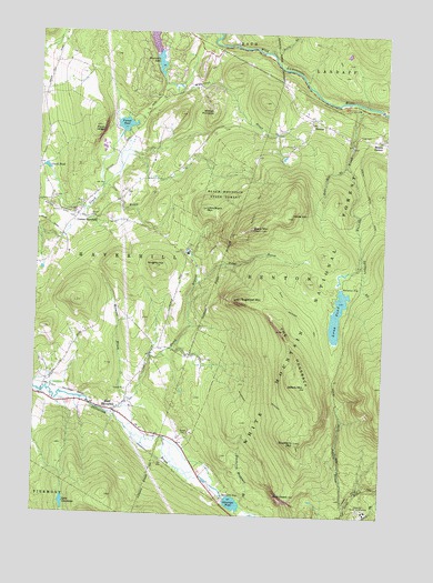
East Haverhill, NH USGS Topographic Map
Click on map above to begin viewing in our Map Viewer.

This topographic map contains these locations and features:
Feature Name Type Latitude Longitude GNIS ID View Map
Ammonoosuc Fish and Game ClubLocaleN44.1167°W71.9126°1916398View Map
BentonPopulated PlaceN44.1031°W71.9018°871489View Map
Benton CemeteryCemeteryN44.1025°W71.8999°1916422View Map
Black MountainSummitN44.0745°W71.9237°871524View Map
Black Mountain State ForestForestN44.0820°W71.9345°871528View Map
Black Mountain TrailTrailN44.0548°W71.9106°871529View Map
Blueberry MountainSummitN44.0195°W71.9051°871545View Map
Blueberry Mountain BrookStreamN44.0034°W71.9248°871546View Map
Blueberry Mountain TrailTrailN44.0295°W71.9143°871547View Map
Boutin CornerPopulated PlaceN44.0981°W71.8759°871560View Map
Brier Hill School (historical)SchoolN44.1137°W71.9951°1916436View Map
Center HaverhillPopulated PlaceN44.0770°W71.9856°871652View Map
Center Haverhill CemeteryCemeteryN44.0772°W71.9865°1916478View Map
Chippewa TrailTrailN44.0712°W71.9345°871673View Map
Church at the Crossroads Advent Christian ChurchChurchN44.0773°W71.9851°1916487View Map
Clark PondLakeN44.0897°W71.9966°871687View Map
East CemeteryCemeteryN44.0988°W71.8843°871830View Map
East HaverhillPopulated PlaceN44.0267°W71.9712°871833View Map
East Haverhill CemeteryCemeteryN44.0291°W71.9895°1916523View Map
East Haverhill United Methodist ChurchChurchN44.0278°W71.9693°1916524View Map
French PondLakeN44.1010°W71.9685°871914View Map
Glencliff State SanatoriumHospitalN44.0017°W71.8801°871943View Map
Haverhill Cooperative Middle SchoolSchoolN44.0773°W71.9997°1916584View Map
Howe HillStreamN44.0912°W71.8890°872053View Map
Howe HillSummitN44.0776°W71.9104°872054View Map
Jeffers BrookStreamN44.0026°W71.8865°872096View Map
Jeffers MountainSummitN44.0340°W71.9020°872097View Map
Knights HillSummitN44.0642°W71.9579°872145View Map
Lake ConstanceLakeN44.0028°W71.9887°871720View Map
Little Black MountainSummitN44.0792°W71.9409°872183View Map
Long PondReservoirN44.0524°W71.8909°872214View Map
Long Pond DamDamN44.0584°W71.8895°1775230View Map
Long Pond Picnic AreaLocaleN44.0598°W71.8898°1916672View Map
Long Pond Picnic GroundLocaleN44.0601°W71.8904°873096View Map
Lower Mountain LakeReservoirN44.1236°W71.9591°1775100View Map
Mountain LakesPopulated PlaceN44.1215°W71.9554°2025415View Map
Mountain Lakes Census Designated PlaceCensusN44.1205°W71.9580°2629730View Map
North Branch Oliverian BrookStreamN44.0262°W71.9729°872391View Map
Oliverian DamDamN44.0084°W71.9279°1775234View Map
Oliverian PondReservoirN44.0033°W71.9273°872434View Map
Oliverian Station (historical)LocaleN44.0253°W71.9704°1916738View Map
Owls HeadRidgeN44.0056°W71.9065°872448View Map
Petty BrookStreamN44.1206°W71.9190°872490View Map
Pond LedgeBenchN44.0995°W71.9776°872519View Map
School Number 6 (historical)SchoolN44.0434°W71.9559°1916810View Map
Spillman BrookStreamN44.0681°W71.8834°872713View Map
Sugarloaf MountainSummitN44.0565°W71.9273°872761View Map
The HogsbackRidgeN44.0437°W71.9073°872787View Map
Titus BrookStreamN44.0598°W71.9431°872823View Map
Town of BentonCivilN44.0411°W71.8768°873544View Map
Town of HaverhillCivilN44.0747°W71.9955°873621View Map
Upper Mountain LakeReservoirN44.1173°W71.9561°1775108View Map
Upper Mountain Lake DamDamN44.1202°W71.9570°2772443View Map
Upper Mountain Lake DamDamN44.1202°W71.9570°1775099View Map
Whitcher BrookStreamN44.1073°W71.8856°872904View Map
Whites PinnaclePillarN44.1045°W71.9390°872924View Map
Wilmont BrookStreamN44.0298°W71.9656°872956View Map
WYKR-FM (Haverhill)TowerN44.1137°W71.9812°873338View Map

Note: Coordinates in the location and feature list above are referenced to NAD83 datum.


Copyright (C) 2008-2024 Ryan Niemi / Sunset Dynamics ... All Rights Reserved