TopoQuest Logo
Do you find TopoQuest useful?
Help keep TopoQuest running and adding new maps/features by donating!
Bitcoin:  19c7KJd3qBynnjoSw5npx9KScwjBe4ifkT
Litecoin:  LXs6TkuXGGXo1vDsWCkWVdjQX94eUKd6ui
Home View Maps Find Maps Find Places Resources & Links


East Tawas, Michigan Topographic Map

USGS Map Title: East Tawas, MI
USGS Map MRC: 44083C4
DRG (GeoTIFF) Download: o44083c4.tif


Neighboring USGS Topographic Map Quads:


  Sid Town, MI  
44083D5
 

  Foote Site Village, MI  
44083D4
 

  Oscoda, MI  
44083D3
 

  Tawas City, MI  
44083C5
 

  East Tawas, MI  
44083C4
 

  Spencer Lake, MI  
44083C3
 

  Alabaster, MI  
44083B5


Map MRC Location:

N45°
W84°
N45°
W83°
H8 H7 H6 H5 H4 H3 H2 H1
G8 G7 G6 G5 G4 G3 G2 G1
F8 F7 F6 F5 F4 F3 F2 F1
E8 E7 E6 E5 E4 E3 E2 E1
D8 D7 D6 D5 D4 D3 D2 D1
C8 C7 C6 C5 C4 C3 C2 C1
B8 B7 B6 B5 B4 B3 B2 B1
A8 A7 A6 A5 A4 A3 A2 A1
N44°
W84°
N44°
W83°

East Tawas, MI USGS 1:24K Topographic Map Preview:
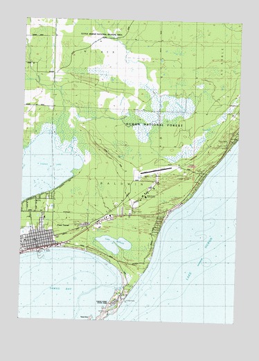
East Tawas, MI USGS Topographic Map
Click on map above to begin viewing in our Map Viewer.

This topographic map contains these locations and features:
Feature Name Type Latitude Longitude GNIS ID View Map
American Legion CemeteryCemeteryN44.2897°W83.4614°2514229View Map
Apostolic Church of East TawasChurchN44.2786°W83.4986°2513861View Map
Bolen ParkParkN44.2883°W83.4922°2513882View Map
Bright Horizons Learning CenterSchoolN44.3017°W83.4280°1617131View Map
Christ Church EpiscopalChurchN44.2808°W83.4925°2513889View Map
Church of the NazareneChurchN44.2811°W83.4806°2513890View Map
City of East TawasCivilN44.2869°W83.4837°1626209View Map
Coast Guard DockLocaleN44.2634°W83.4439°1618610View Map
Coast Guard Station TawasMilitaryN44.2554°W83.4509°2512144View Map
Dewey Durant ParkParkN44.2858°W83.4986°1617135View Map
East TawasPopulated PlaceN44.2795°W83.4903°625264View Map
East Tawas Assembly of God ChurchChurchN44.2836°W83.4881°2513887View Map
East Tawas City HallBuildingN44.3000°W83.4889°2513879View Map
East Tawas City ParkParkN44.2778°W83.4958°2513888View Map
East Tawas Fire DepartmentBuildingN44.2807°W83.4890°2513880View Map
East Tawas LibraryBuildingN44.2808°W83.4917°2513885View Map
East Tawas Post OfficePost OfficeN44.2828°W83.4911°2513899View Map
East Tawas State DockLocaleN44.2771°W83.4876°2496778View Map
East Tawas StationLocaleN44.2778°W83.4997°2513903View Map
Fountain CreekStreamN44.3483°W83.4919°626326View Map
Grace Evangelical Lutheran ChurchChurchN44.2833°W83.4903°2513891View Map
Gray CreekStreamN44.3222°W83.4972°627257View Map
Greenwood CemeteryCemeteryN44.2895°W83.4625°627388View Map
Holy Family Catholic ChurchChurchN44.2825°W83.4972°2513894View Map
Holy Family Catholic SchoolSchoolN44.2828°W83.4972°2513898View Map
Iosco County AirportAirportN44.3121°W83.4224°1623882View Map
Iosco County Emergency Medical Services Station 1BuildingN44.2944°W83.4439°2661913View Map
Iosco-Arenac District LibraryBuildingN44.2797°W83.4911°2513878View Map
Jerrys MarinaLocaleN44.2639°W83.4391°1618609View Map
Kingdom Hall of Jehovah's WitnessesChurchN44.2917°W83.4511°2513896View Map
Kunze CreekStreamN44.3195°W83.4725°629891View Map
Lake Huron Community ChurchChurchN44.2825°W83.4956°2513893View Map
Lake SolitudeLakeN44.2820°W83.4455°638236View Map
Living Waters Christian ChurchChurchN44.2881°W83.4939°2513892View Map
Lumbering on the Huron Shore Historical MarkerParkN44.2800°W83.4856°2514235View Map
Michigan State Police DepartmentBuildingN44.2799°W83.4858°2737558View Map
Saint Joseph's CemeteryCemeteryN44.2894°W83.4639°2514230View Map
Silver CreekStreamN44.3256°W83.4814°637927View Map
Tawa Beach Post Office (historical)Post OfficeN44.2778°W83.4528°1926608View Map
Tawas Area Presbyterian ChurchChurchN44.2936°W83.4356°2513897View Map
Tawas BayBayN44.2667°W83.4833°1614604View Map
Tawas Bay Yacht ClubLocaleN44.2625°W83.4422°1618611View Map
Tawas Beach ClubLocaleN44.2770°W83.4533°1618613View Map
Tawas LakeLakeN44.3109°W83.4895°1614606View Map
Tawas LightLocaleN44.2536°W83.4494°1618612View Map
Tawas Point State ParkParkN44.2556°W83.4461°1617132View Map
Tawas Point State Park CampgroundLocaleN44.2578°W83.4444°2513881View Map
Tom Dillon ParkParkN44.2883°W83.4880°1617133View Map
Township of BaldwinCivilN44.3137°W83.4716°1625876View Map
Tuttle DitchCanalN44.3458°W83.4814°1618127View Map
Tuttle Marsh National Wildlife AreaParkN44.3667°W83.4583°1617134View Map

Note: Coordinates in the location and feature list above are referenced to NAD83 datum.


Copyright (C) 2008-2025 Ryan Niemi / Sunset Dynamics ... All Rights Reserved