TopoQuest Logo
Do you find TopoQuest useful?
Help keep TopoQuest running and adding new maps/features by donating!
Bitcoin:  19c7KJd3qBynnjoSw5npx9KScwjBe4ifkT
Litecoin:  LXs6TkuXGGXo1vDsWCkWVdjQX94eUKd6ui
Home View Maps Find Maps Find Places Resources & Links


Oscoda, Michigan Topographic Map

USGS Map Title: Oscoda, MI
USGS Map MRC: 44083D3
DRG (GeoTIFF) Download: o44083d3.tif


Neighboring USGS Topographic Map Quads:


  Mikado, MI  
44083E4
 

  Greenbush, MI  
44083E3


  Foote Site Village, MI  
44083D4
 

  Oscoda, MI  
44083D3


  East Tawas, MI  
44083C4
 

  Spencer Lake, MI  
44083C3


Map MRC Location:

N45°
W84°
N45°
W83°
H8 H7 H6 H5 H4 H3 H2 H1
G8 G7 G6 G5 G4 G3 G2 G1
F8 F7 F6 F5 F4 F3 F2 F1
E8 E7 E6 E5 E4 E3 E2 E1
D8 D7 D6 D5 D4 D3 D2 D1
C8 C7 C6 C5 C4 C3 C2 C1
B8 B7 B6 B5 B4 B3 B2 B1
A8 A7 A6 A5 A4 A3 A2 A1
N44°
W84°
N44°
W83°

Oscoda, MI USGS 1:24K Topographic Map Preview:
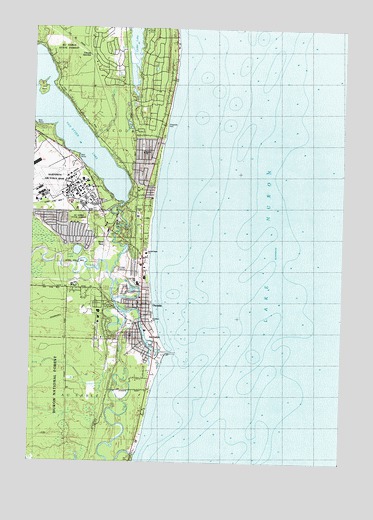
Oscoda, MI USGS Topographic Map
Click on map above to begin viewing in our Map Viewer.

This topographic map contains these locations and features:
Feature Name Type Latitude Longitude GNIS ID View Map
Alcona Health CenterHospitalN44.4531°W83.3531°2513846View Map
Alpena Community College-Huron Shores CampusSchoolN44.4503°W83.3517°2513847View Map
Alpena State ForestForestN44.4792°W83.3541°620020View Map
Au SablePopulated PlaceN44.4108°W83.3322°620323View Map
Au Sable Census Designated PlaceCensusN44.4104°W83.3423°2393322View Map
Au Sable Childrens ParkParkN44.4081°W83.3292°2513859View Map
Au Sable Post Office (historical)Post OfficeN44.4108°W83.3322°2514216View Map
Au Sable RiverStreamN44.4070°W83.3211°1619052View Map
Au Sable Township CemeteryCemeteryN44.4094°W83.3369°2514226View Map
AuSable Finish Line ParkParkN44.4167°W83.3331°2513836View Map
Ausable Mobile Home VillagePopulated PlaceN44.4114°W83.3311°2513848View Map
Ausable River ParkParkN44.4056°W83.3222°2513860View Map
AuSable River ParkParkN44.4047°W83.3216°1618813View Map
AuSable Township HallBuildingN44.4114°W83.3356°2513835View Map
AuSable-Oscoda StationLocaleN44.4222°W83.3450°2513834View Map
Billy McCraig ParkParkN44.4183°W83.3536°2513837View Map
Cedar Lake SchoolSchoolN44.4270°W83.3322°1617123View Map
Charter Township of Au SableCivilN44.3819°W83.3656°1625865View Map
Church of ChristChurchN44.4489°W83.3336°2513843View Map
Dock Reserve Historical MarkerParkN44.4189°W83.3269°2514237View Map
Duell LakeLakeN44.4358°W83.3566°624964View Map
Emmanuel Episcopal ChurchChurchN44.4200°W83.3336°2513852View Map
Fellow Marine SalesLocaleN44.4089°W83.3261°1618615View Map
Grace Community ChurchChurchN44.4558°W83.3567°2513842View Map
Great Lakes Family Medicine ClinicHospitalN44.4175°W83.3297°2513850View Map
Green Pack House Historical MarkerParkN44.4256°W83.3300°2514233View Map
Hope Lutheran ChurchChurchN44.4200°W83.3336°2513841View Map
Huron ChurchChurchN44.4645°W83.3305°1617121View Map
Huron Shores Church of the NazareneChurchN44.4106°W83.3322°2513851View Map
Iosco County Emergency Medical Services Station 3BuildingN44.4207°W83.3446°2661919View Map
Lake Chevalier Claim Historical MarkerParkN44.4128°W83.3306°2514236View Map
Lakewood Shores Golf CourseLocaleN44.4983°W83.3400°2513831View Map
Lincoln JunctionPopulated PlaceN44.4925°W83.3533°1617683View Map
Lincoln Junction StationLocaleN44.4922°W83.3528°2513904View Map
Loud IslandIslandN44.4820°W83.3730°631126View Map
Old Au Sable RiverStreamN44.3770°W83.3327°620329View Map
OscodaPopulated PlaceN44.4203°W83.3308°634132View Map
Oscoda Area First RespondersBuildingN44.4207°W83.3446°2661918View Map
Oscoda Assembly of God ChurchChurchN44.4422°W83.3311°2513854View Map
Oscoda Baptist ChurchChurchN44.4428°W83.3308°2513855View Map
Oscoda Census Designated PlaceCensusN44.4249°W83.3340°2393174View Map
Oscoda Fire Department Station 1 HeadquartersBuildingN44.4200°W83.3307°2513833View Map
Oscoda Harbor of RefugeHarborN44.4090°W83.3276°2496777View Map
Oscoda Health ParkHospitalN44.4514°W83.3300°2513838View Map
Oscoda KOA CampgroundsLocaleN44.3914°W83.3433°2513832View Map
Oscoda Mobile Home ParkPopulated PlaceN44.4667°W83.3306°2513858View Map
Oscoda Post OfficePost OfficeN44.4222°W83.3311°2513849View Map
Oscoda Township LibraryBuildingN44.4550°W83.3569°2513840View Map
Oscoda Township Police DepartmentBuildingN44.4201°W83.3307°2513829View Map
Oscoda United Methodist ChurchChurchN44.4197°W83.3317°2513853View Map
Oscoda Yacht ClubLocaleN44.4095°W83.3269°1618614View Map
Oscoda-Wurtsmith AirportAirportN44.4538°W83.3740°1624091View Map
Pentecostal Lighthouse ChurchChurchN44.4506°W83.3561°2513845View Map
Phelan CreekStreamN44.4681°W83.3508°634750View Map
Pinecrest CemeteryCemeteryN44.4203°W83.3486°2514227View Map
Sacred Heart CemeteryCemeteryN44.4211°W83.3489°2514228View Map
Sacred Heart ChurchChurchN44.4350°W83.3286°1617120View Map
Saint Johns ChurchChurchN44.4158°W83.3258°1617119View Map
Sawyer Canoe CompanyLocaleN44.4122°W83.3283°1618616View Map
Skeel SpurLocaleN44.4370°W83.3461°1617118View Map
Trinity ChurchChurchN44.4464°W83.3327°1617122View Map
United States Forest Service Huron Shores StationBuildingN44.4479°W83.3483°2626828View Map
Van Etten CreekStreamN44.4278°W83.3439°1615471View Map
Van Etten LakeLakeN44.4744°W83.3637°1615473View Map
Van Etten Lake State Forest CampgroundLocaleN44.4708°W83.3722°2513883View Map
Weavers MarinaLocaleN44.4072°W83.3258°1618617View Map
Whispering Woods Mobile Home CommunityPopulated PlaceN44.4414°W83.3494°2513857View Map
Wurtsmith Air MuseumBuildingN44.4589°W83.3572°2513830View Map

Note: Coordinates in the location and feature list above are referenced to NAD83 datum.


Copyright (C) 2008-2024 Ryan Niemi / Sunset Dynamics ... All Rights Reserved