TopoQuest Logo
Do you find TopoQuest useful?
Help keep TopoQuest running and adding new maps/features by donating!
Bitcoin:  19c7KJd3qBynnjoSw5npx9KScwjBe4ifkT
Litecoin:  LXs6TkuXGGXo1vDsWCkWVdjQX94eUKd6ui
Home View Maps Find Maps Find Places Resources & Links


Eastabuchie, Mississippi Topographic Map

USGS Map Title: Eastabuchie, MS
USGS Map MRC: 31089D3
DRG (GeoTIFF) Download: o31089d3.tif


Neighboring USGS Topographic Map Quads:


  Seminary, MS  
31089E4
 

  Moselle, MS  
31089E3
 

  Ellisville, MS  
31089E2
 

  Sanford, MS  
31089D4
 

  Eastabuchie, MS  
31089D3
 

  Barrontown, MS  
31089D2
 

  Hattiesburg SW, MS  
31089C4
 

  Hattiesburg, MS  
31089C3
 

  Carterville, MS  
31089C2


Map MRC Location:

N32°
W90°
N32°
W89°
H8 H7 H6 H5 H4 H3 H2 H1
G8 G7 G6 G5 G4 G3 G2 G1
F8 F7 F6 F5 F4 F3 F2 F1
E8 E7 E6 E5 E4 E3 E2 E1
D8 D7 D6 D5 D4 D3 D2 D1
C8 C7 C6 C5 C4 C3 C2 C1
B8 B7 B6 B5 B4 B3 B2 B1
A8 A7 A6 A5 A4 A3 A2 A1
N31°
W90°
N31°
W89°

Eastabuchie, MS USGS 1:24K Topographic Map Preview:
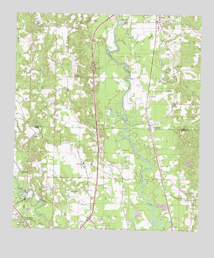
Eastabuchie, MS USGS Topographic Map
Click on map above to begin viewing in our Map Viewer.

This topographic map contains these locations and features:
Feature Name Type Latitude Longitude GNIS ID View Map
AlbeisonPopulated PlaceN31.4913°W89.2792°685442View Map
Albeison BridgeBridgeN31.4957°W89.3015°685443View Map
Barlow BranchStreamN31.4704°W89.2995°685449View Map
Baylss BranchStreamN31.4391°W89.2992°685450View Map
Big CreekStreamN31.3924°W89.3628°667098View Map
BowiePopulated PlaceN31.3929°W89.3717°691722View Map
Callahan CemeteryCemeteryN31.4954°W89.3320°667921View Map
Dahmer Lake DamDamN31.4435°W89.3101°680720View Map
DragonPopulated PlaceN31.3777°W89.2664°691824View Map
EastabuchiePopulated PlaceN31.4354°W89.2834°669617View Map
Eastabuchie CemeteryCemeteryN31.4371°W89.2887°707342View Map
Eastabuchie Post OfficePost OfficeN31.4366°W89.2855°2768820View Map
Eaton CemeteryCemeteryN31.4224°W89.3334°669634View Map
EatonvillePopulated PlaceN31.4141°W89.3292°669635View Map
Eatonville FlatFlatN31.4168°W89.3376°706340View Map
Edmonson CemeteryCemeteryN31.4757°W89.2953°669676View Map
Estabutchie School (historical)SchoolN31.4357°W89.2848°707347View Map
Fairchild CemeteryCemeteryN31.4852°W89.2784°669867View Map
Hattiesburg Community ChurchChurchN31.4226°W89.3212°2597082View Map
Hattiesburg/Laurel Regional AirportAirportN31.4698°W89.3347°680317View Map
Heidelberg CemeteryCemeteryN31.4216°W89.3026°671087View Map
Hopewell CemeteryCemeteryN31.4966°W89.3023°671407View Map
Hopewell Church (historical)ChurchN31.4971°W89.3001°685509View Map
Hudson CemeteryCemeteryN31.3771°W89.3676°671557View Map
Interchange 69CrossingN31.3816°W89.3234°691482View Map
Interchange 73CrossingN31.4313°W89.3190°691483View Map
Interchange 76CrossingN31.4688°W89.3228°691484View Map
Interchange 78CrossingN31.4991°W89.3112°691485View Map
Jenkins Ferry (historical)CrossingN31.4254°W89.2956°683919View Map
Johnsons Ferry (historical)CrossingN31.4013°W89.3717°683920View Map
Kelly (historical)LocaleN31.4168°W89.2987°706347View Map
Kelly CemeteryCemeteryN31.4177°W89.2992°672084View Map
Knight CemeteryCemeteryN31.4666°W89.2976°672199View Map
LeevillePopulated PlaceN31.3941°W89.2564°691999View Map
Lynn Cartlage Lake DamDamN31.4168°W89.2617°680714View Map
Macedonia Volunteer Fire Department Station 2BuildingN31.3936°W89.2569°2667880View Map
Mary Magdalene Baptist ChurchChurchN31.3971°W89.3317°673212View Map
MaybankPopulated PlaceN31.4077°W89.3698°692052View Map
Maybank Baptist ChurchChurchN31.4049°W89.3659°2596839View Map
Mineral CreekStreamN31.3766°W89.3515°673667View Map
Monroe (historical)LocaleN31.4243°W89.3173°683929View Map
Moselle Elementary SchoolSchoolN31.4966°W89.2806°707366View Map
Moselle Memorial Baptist ChurchChurchN31.4955°W89.2803°685536View Map
Moselle United Methodist ChurchChurchN31.4952°W89.2795°685537View Map
Moselle United Methodist ChurchChurchN31.4331°W89.2843°2596983View Map
New Zion Baptist ChurchChurchN31.4563°W89.3425°674873View Map
North Forrest Attendance CenterSchoolN31.4132°W89.3281°706353View Map
North Forrest Volunteer Fire Department Station 2BuildingN31.4271°W89.3549°2668034View Map
Old Leeville CemeteryCemeteryN31.3966°W89.2562°675199View Map
Pentecostal Tabernacle United Pentecostal ChurchChurchN31.3847°W89.3725°2596156View Map
Pine Grove Baptist ChurchChurchN31.4593°W89.2903°675825View Map
ProvidencePopulated PlaceN31.4307°W89.3612°683944View Map
Providence Baptist ChurchChurchN31.4291°W89.3576°676372View Map
Providence CreekStreamN31.4035°W89.3728°676398View Map
Punch BranchStreamN31.4235°W89.3417°685575View Map
Quick CemeteryCemeteryN31.3760°W89.2970°676432View Map
Rapids on the River Boat RampLocaleN31.3960°W89.3657°2596633View Map
Rawles Mill (historical)LocaleN31.4041°W89.3720°706357View Map
Rawles SpringsSpringN31.3791°W89.3701°706358View Map
Rawls SpringsPopulated PlaceN31.3807°W89.3715°676496View Map
Rawls Springs Attendance CenterSchoolN31.3816°W89.3712°706359View Map
Rawls Springs Baptist ChurchChurchN31.3799°W89.3728°683945View Map
Robert E Lee School (historical)SchoolN31.4929°W89.3515°707389View Map
Shady Grove Baptist ChurchChurchN31.4349°W89.3123°677557View Map
Shady Grove CemeteryCemeteryN31.4349°W89.3128°1805871View Map
SheltonPopulated PlaceN31.4924°W89.3492°692224View Map
Shelton Baptist ChurchChurchN31.4647°W89.3408°2596608View Map
Shelton Baptist ChurchChurchN31.4929°W89.3528°685591View Map
Shelton CemeteryCemeteryN31.4935°W89.3528°707396View Map
Supervisor District 2CivilN31.3880°W89.3640°711844View Map
Thomas CreekStreamN31.4841°W89.3095°678679View Map
Unity Baptist ChurchChurchN31.4546°W89.2859°2596568View Map
University of Southern Mississippi Golf Course Lake DamDamN31.3868°W89.3651°680694View Map
WBKH-AM (Hattiesburg)TowerN31.3760°W89.3303°680080View Map
WDAM-TV (Laurel)TowerN31.4535°W89.2848°680271View Map
West Hattiesburg Congregation ChurchChurchN31.3826°W89.3703°2596307View Map
Wheelerville School (historical)SchoolN31.4541°W89.3731°685618View Map

Note: Coordinates in the location and feature list above are referenced to NAD83 datum.


Copyright (C) 2008-2024 Ryan Niemi / Sunset Dynamics ... All Rights Reserved