TopoQuest Logo
Do you find TopoQuest useful?
Help keep TopoQuest running and adding new maps/features by donating!
Bitcoin:  19c7KJd3qBynnjoSw5npx9KScwjBe4ifkT
Litecoin:  LXs6TkuXGGXo1vDsWCkWVdjQX94eUKd6ui
Home View Maps Find Maps Find Places Resources & Links


Sanford, Mississippi Topographic Map

USGS Map Title: Sanford, MS
USGS Map MRC: 31089D4
DRG (GeoTIFF) Download: o31089d4.tif


Neighboring USGS Topographic Map Quads:


  Williamsburg, MS  
31089E5
 

  Seminary, MS  
31089E4
 

  Moselle, MS  
31089E3
 

  Sumrall, MS  
31089D5
 

  Sanford, MS  
31089D4
 

  Eastabuchie, MS  
31089D3
 

  Oloh, MS  
31089C5
 

  Hattiesburg SW, MS  
31089C4
 

  Hattiesburg, MS  
31089C3


Map MRC Location:

N32°
W90°
N32°
W89°
H8 H7 H6 H5 H4 H3 H2 H1
G8 G7 G6 G5 G4 G3 G2 G1
F8 F7 F6 F5 F4 F3 F2 F1
E8 E7 E6 E5 E4 E3 E2 E1
D8 D7 D6 D5 D4 D3 D2 D1
C8 C7 C6 C5 C4 C3 C2 C1
B8 B7 B6 B5 B4 B3 B2 B1
A8 A7 A6 A5 A4 A3 A2 A1
N31°
W90°
N31°
W89°

Sanford, MS USGS 1:24K Topographic Map Preview:
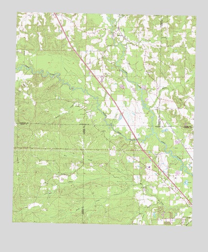
Sanford, MS USGS Topographic Map
Click on map above to begin viewing in our Map Viewer.

This topographic map contains these locations and features:
Feature Name Type Latitude Longitude GNIS ID View Map
Bay Springs School (historical)SchoolN31.4641°W89.4378°710605View Map
Bowie Creek Landing Boat RampLocaleN31.4259°W89.4154°2596922View Map
Bryant CemeteryCemeteryN31.4660°W89.4084°667711View Map
Bullock CreekStreamN31.4902°W89.4351°667783View Map
Byrd CemeteryCemeteryN31.4893°W89.4684°667889View Map
Clinton CemeteryCemeteryN31.4041°W89.4653°668611View Map
Cross CreekStreamN31.3885°W89.3965°668964View Map
Dry CreekStreamN31.4021°W89.4181°669412View Map
Ed Turner Lake DamDamN31.3968°W89.3867°680705View Map
Edmonson CemeteryCemeteryN31.4168°W89.4009°669675View Map
First Baptist Church of SanfordChurchN31.4916°W89.4295°710638View Map
Grandberry Plantation (historical)LocaleN31.4529°W89.4042°710646View Map
Lott CemeteryCemeteryN31.3998°W89.3935°672884View Map
Lott CemeteryCemeteryN31.4449°W89.4559°672885View Map
Lott CemeteryCemeteryN31.4816°W89.4384°672886View Map
LuxPopulated PlaceN31.4452°W89.4009°692026View Map
Lux Church (historical)ChurchN31.4502°W89.4003°710668View Map
Lux School (historical)SchoolN31.4502°W89.4001°710669View Map
McCall CreekStreamN31.4435°W89.4428°673289View Map
Nichols BranchStreamN31.4807°W89.4273°674917View Map
Okatoma CreekStreamN31.4304°W89.4034°691591View Map
Rawl Springs Volunteer Fire DepartmentBuildingN31.4070°W89.4001°2667917View Map
Rawls CemeteryCemeteryN31.4107°W89.3751°676493View Map
Rawls Springs Baptist Church CemeteryCemeteryN31.3792°W89.3797°2352910View Map
Rawls Springs Census Designated PlaceCensusN31.3796°W89.3878°2586608View Map
Rawls Springs Community CenterBuildingN31.3825°W89.3797°2597109View Map
Rooty CreekStreamN31.3993°W89.4170°676836View Map
Sacier Pond DamDamN31.4185°W89.4001°680715View Map
SanfordPopulated PlaceN31.4868°W89.4270°677399View Map
Sanford Academy (historical)SchoolN31.4927°W89.4292°710716View Map
Sanford Missionary Baptist ChurchChurchN31.4868°W89.4253°710717View Map
Sanford School (historical)SchoolN31.4921°W89.4292°710718View Map
Sanford United Methodist ChurchChurchN31.4907°W89.4290°710719View Map
Shady Cove Recreational Vehicle CampgroundLocaleN31.4195°W89.4070°2597119View Map
Shelton CreekStreamN31.4441°W89.4073°691611View Map
Simmons Airport (historical)AirportN31.4654°W89.4376°680316View Map
Stir (historical)LocaleN31.3896°W89.3853°683955View Map
Sutton School (historical)SchoolN31.3985°W89.4767°685812View Map
Watts CemeteryCemeteryN31.4566°W89.4928°679385View Map

Note: Coordinates in the location and feature list above are referenced to NAD83 datum.


Copyright (C) 2008-2024 Ryan Niemi / Sunset Dynamics ... All Rights Reserved