TopoQuest Logo
Do you find TopoQuest useful?
Help keep TopoQuest running and adding new maps/features by donating!
Bitcoin:  19c7KJd3qBynnjoSw5npx9KScwjBe4ifkT
Litecoin:  LXs6TkuXGGXo1vDsWCkWVdjQX94eUKd6ui
Home View Maps Find Maps Find Places Resources & Links


Sucia Island, Washington Topographic Map

USGS Map Title: Sucia Island, WA
USGS Map MRC: 48122G8
DRG (GeoTIFF) Download: o48122g8.tif


Neighboring USGS Topographic Map Quads:


  Point Roberts, WA  
48123H1


  Birch Point, WA  
48122H7


  Sucia Island, WA  
48122G8


  Waldron Island, WA  
48123F1
 

  Eastsound, WA  
48122F8
 

  Mount Constitution, WA  
48122F7


Map MRC Location:

N49°
W123°
N49°
W122°
H8 H7 H6 H5 H4 H3 H2 H1
G8 G7 G6 G5 G4 G3 G2 G1
F8 F7 F6 F5 F4 F3 F2 F1
E8 E7 E6 E5 E4 E3 E2 E1
D8 D7 D6 D5 D4 D3 D2 D1
C8 C7 C6 C5 C4 C3 C2 C1
B8 B7 B6 B5 B4 B3 B2 B1
A8 A7 A6 A5 A4 A3 A2 A1
N48°
W123°
N48°
W122°

Sucia Island, WA USGS 1:24K Topographic Map Preview:
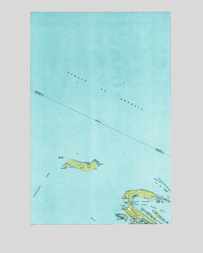
Sucia Island, WA USGS Topographic Map
Click on map above to begin viewing in our Map Viewer.

This topographic map contains these locations and features:
Feature Name Type Latitude Longitude GNIS ID View Map
Active CoveBayN48.7854°W122.9677°1502934View Map
Alden PointCapeN48.7890°W122.9713°1502961View Map
Clements ReefBarN48.7754°W122.8874°1504014View Map
Cluster IslandsIslandN48.7637°W122.8869°1504033View Map
Echo BayBayN48.7609°W122.8949°1504669View Map
Ewing CoveBayN48.7651°W122.8871°1504795View Map
Ewing IslandIslandN48.7644°W122.8808°1504796View Map
Fossil BayBayN48.7501°W122.9005°1504981View Map
Fox CoveBayN48.7523°W122.9094°1505012View Map
Harnden IslandIslandN48.7517°W122.9003°1510404View Map
Justice IslandIslandN48.7577°W122.9004°2726022View Map
Lawson BluffCliffN48.7687°W122.9152°1506110View Map
Little Patos IslandIslandN48.7845°W122.9688°1506220View Map
Little Sucia IslandIslandN48.7544°W122.9175°1506231View Map
Mud BayBayN48.7509°W122.8966°1506860View Map
North Finger IslandIslandN48.7539°W122.8856°1507031View Map
Patos IslandIslandN48.7845°W122.9544°1507327View Map
Patos LightLocaleN48.7890°W122.9716°1533195View Map
Shallow BayBayN48.7626°W122.9166°1508244View Map
South Finger IslandIslandN48.7539°W122.8928°1534605View Map
Strait of GeorgiaChannelN48.8315°W122.9446°1509730View Map
Sucia IslandIslandN48.7621°W122.9132°1508791View Map
Sucia Island State ParkParkN48.7621°W122.9130°1513953View Map
Sucia IslandsIslandN48.7621°W122.9007°1531689View Map
Toe PointCapeN48.7851°W122.9407°1509038View Map
West BankBarN48.7529°W122.9457°1509380View Map

Note: Coordinates in the location and feature list above are referenced to NAD83 datum.


Copyright (C) 2008-2024 Ryan Niemi / Sunset Dynamics ... All Rights Reserved