TopoQuest Logo
Do you find TopoQuest useful?
Help keep TopoQuest running and adding new maps/features by donating!
Bitcoin:  19c7KJd3qBynnjoSw5npx9KScwjBe4ifkT
Litecoin:  LXs6TkuXGGXo1vDsWCkWVdjQX94eUKd6ui
Home View Maps Find Maps Find Places Resources & Links


Archuleta, New Mexico Topographic Map

USGS Map Title: Archuleta, NM
USGS Map MRC: 36107G6
DRG (GeoTIFF) Download: o36107g6.tif


Neighboring USGS Topographic Map Quads:


  Mount Nebo, NM  
36107H7
 

  Anastacio Spring, NM  
36107H6
 

  Burnt Mesa, NM  
36107H5
 

  Turley, NM  
36107G7
 

  Archuleta, NM  
36107G6
 

  Navajo Dam, NM  
36107G5
 

  Blanco, NM  
36107F7
 

  Cutter Canyon, NM  
36107F6
 

  Delgadita Mesa, NM  
36107F5


Map MRC Location:

N37°
W108°
N37°
W107°
H8 H7 H6 H5 H4 H3 H2 H1
G8 G7 G6 G5 G4 G3 G2 G1
F8 F7 F6 F5 F4 F3 F2 F1
E8 E7 E6 E5 E4 E3 E2 E1
D8 D7 D6 D5 D4 D3 D2 D1
C8 C7 C6 C5 C4 C3 C2 C1
B8 B7 B6 B5 B4 B3 B2 B1
A8 A7 A6 A5 A4 A3 A2 A1
N36°
W108°
N36°
W107°

Archuleta, NM USGS 1:24K Topographic Map Preview:
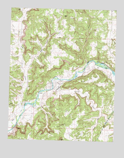
Archuleta, NM USGS Topographic Map
Click on map above to begin viewing in our Map Viewer.

This topographic map contains these locations and features:
Feature Name Type Latitude Longitude GNIS ID View Map
ArchuletaPopulated PlaceN36.7942°W107.7089°900289View Map
Baltazar PeakSummitN36.7506°W107.6889°898628View Map
Crow CanyonValleyN36.8286°W107.7389°888103View Map
Escarbada CanyonValleyN36.7761°W107.6406°900105View Map
Gobernador CanyonValleyN36.7967°W107.7076°938719View Map
Gobernador Canyon ArchArchN36.7853°W107.6686°2651457View Map
La Manga CanyonValleyN36.8200°W107.7326°900099View Map
Little Pump CanyonValleyN36.8481°W107.7409°897398View Map
Martinez MesaSummitN36.8081°W107.6637°900101View Map
Melquadis PointSummitN36.7581°W107.7384°900103View Map
Minix CanyonValleyN36.8711°W107.7356°900098View Map
Minix SpringSpringN36.8734°W107.7423°900096View Map
Navajo Dam Census Designated PlaceCensusN36.7981°W107.7044°2584162View Map
Navajo Dam Post OfficePost OfficeN36.8048°W107.6972°1721353View Map
Navajo Lake AirportAirportN36.8103°W107.6451°936989View Map
Navajo Lake State ParkParkN36.8011°W107.6926°900548View Map
Prado SpringSpringN36.7838°W107.7490°900104View Map
Pump CanyonValleyN36.7798°W107.7324°203941View Map
Pump MesaSummitN36.8178°W107.7006°900100View Map
Pump Mesa Water WellWellN36.8478°W107.6992°927134View Map
Quintana SpringSpringN36.8678°W107.6876°900097View Map
Salvador CanyonValleyN36.7819°W107.7126°900102View Map
San Juan Basin FieldLocaleN36.8639°W107.6342°894438View Map
San Juan County Fire District 10 Navajo DamBuildingN36.8053°W107.6906°2657898View Map
Simon CanyonValleyN36.8228°W107.6589°894858View Map

Note: Coordinates in the location and feature list above are referenced to NAD83 datum.


Copyright (C) 2008-2025 Ryan Niemi / Sunset Dynamics ... All Rights Reserved