TopoQuest Logo
Do you find TopoQuest useful?
Help keep TopoQuest running and adding new maps/features by donating!
Bitcoin:  19c7KJd3qBynnjoSw5npx9KScwjBe4ifkT
Litecoin:  LXs6TkuXGGXo1vDsWCkWVdjQX94eUKd6ui
Home View Maps Find Maps Find Places Resources & Links


Burnt Mesa, New Mexico Topographic Map

USGS Map Title: Burnt Mesa, NM
USGS Map MRC: 36107H5
DRG (GeoTIFF) Download: o36107h5.tif


Neighboring USGS Topographic Map Quads:


  Ignacio, CO  
37107A6
 

  Tiffany, CO  
37107A5
 

  Allison, CO  
37107A4
 

  Anastacio Spring, NM  
36107H6
 

  Burnt Mesa, NM  
36107H5
 

  Bancos Mesa NW, NM  
36107H4
 

  Archuleta, NM  
36107G6
 

  Navajo Dam, NM  
36107G5
 

  Gomez Ranch, NM  
36107G4


Map MRC Location:

N37°
W108°
N37°
W107°
H8 H7 H6 H5 H4 H3 H2 H1
G8 G7 G6 G5 G4 G3 G2 G1
F8 F7 F6 F5 F4 F3 F2 F1
E8 E7 E6 E5 E4 E3 E2 E1
D8 D7 D6 D5 D4 D3 D2 D1
C8 C7 C6 C5 C4 C3 C2 C1
B8 B7 B6 B5 B4 B3 B2 B1
A8 A7 A6 A5 A4 A3 A2 A1
N36°
W108°
N36°
W107°

Burnt Mesa, NM USGS 1:24K Topographic Map Preview:
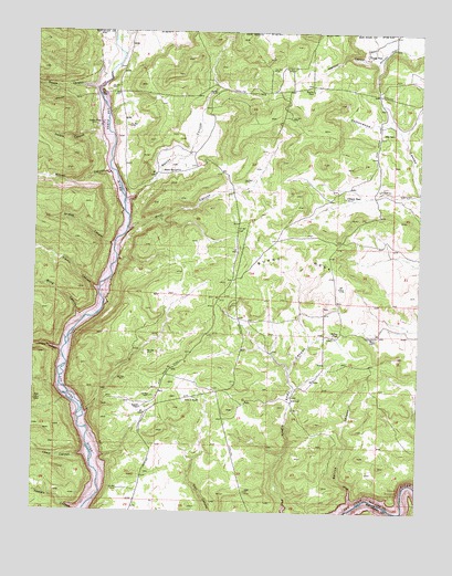
Burnt Mesa, NM USGS Topographic Map
Click on map above to begin viewing in our Map Viewer.

This topographic map contains these locations and features:
Feature Name Type Latitude Longitude GNIS ID View Map
Albino CanyonValleyN36.9328°W107.6053°885660View Map
Benito CanyonValleyN36.9560°W107.5958°184504View Map
Benito SchoolSchoolN36.9636°W107.5806°886214View Map
Blind CanyonValleyN36.9258°W107.6109°886496View Map
Burnt MesaSummitN36.9347°W107.5634°886948View Map
Cemetery CanyonValleyN36.9995°W107.5969°184503View Map
Christopher PlaceLocaleN36.9208°W107.5142°898644View Map
Garcia CanyonValleyN36.9753°W107.6042°889319View Map
Garcia Place (historical)LocaleN36.9761°W107.6042°898656View Map
Grassy CanyonValleyN36.9444°W107.6006°889559View Map
Hole in RockBasinN36.9039°W107.5712°890068View Map
Lewis Park CanyonValleyN36.8897°W107.6084°898364View Map
Lucero PlaceLocaleN36.9019°W107.5901°898672View Map
Mackey PlaceLocaleN36.9847°W107.5359°898673View Map
Mentzel CanyonValleyN36.9969°W107.5151°891847View Map
Mentzel DitchCanalN36.9950°W107.5120°908572View Map
Mullen PlaceLocaleN36.9211°W107.5262°898683View Map
Negro CanyonValleyN36.9167°W107.6164°892411View Map
Reese CanyonValleyN36.9850°W107.6059°893850View Map
Self PlaceLocaleN36.9739°W107.5092°898693View Map
Spruce CanyonValleyN36.8794°W107.5220°895277View Map
Todosio CanyonValleyN36.8756°W107.6109°895718View Map
Ulibarri CanyonValleyN36.9578°W107.5014°895998View Map
Ulibarri Place (historical)LocaleN36.9569°W107.5248°898703View Map
Wilmer CanyonValleyN36.9631°W107.6017°896678View Map
Wool CanyonValleyN36.9483°W107.5942°896769View Map
Young PlaceLocaleN36.9944°W107.5181°898710View Map

Note: Coordinates in the location and feature list above are referenced to NAD83 datum.


Copyright (C) 2008-2024 Ryan Niemi / Sunset Dynamics ... All Rights Reserved