TopoQuest Logo
Do you find TopoQuest useful?
Help keep TopoQuest running and adding new maps/features by donating!
Bitcoin:  19c7KJd3qBynnjoSw5npx9KScwjBe4ifkT
Litecoin:  LXs6TkuXGGXo1vDsWCkWVdjQX94eUKd6ui
Home View Maps Find Maps Find Places Resources & Links


Ebensburg, Pennsylvania Topographic Map

USGS Map Title: Ebensburg, PA
USGS Map MRC: 40078D6
DRG (GeoTIFF) Download: o40078d6.tif


Neighboring USGS Topographic Map Quads:


  Colver, PA  
40078E7
 

  Carrolltown, PA  
40078E6
 

  Ashville, PA  
40078E5
 

  Nanty Glo, PA  
40078D7
 

  Ebensburg, PA  
40078D6
 

  Cresson, PA  
40078D5
 

  Geistown, PA  
40078C7
 

  Beaverdale, PA  
40078C6
 

  Blue Knob, PA  
40078C5


Map MRC Location:

N41°
W79°
N41°
W78°
H8 H7 H6 H5 H4 H3 H2 H1
G8 G7 G6 G5 G4 G3 G2 G1
F8 F7 F6 F5 F4 F3 F2 F1
E8 E7 E6 E5 E4 E3 E2 E1
D8 D7 D6 D5 D4 D3 D2 D1
C8 C7 C6 C5 C4 C3 C2 C1
B8 B7 B6 B5 B4 B3 B2 B1
A8 A7 A6 A5 A4 A3 A2 A1
N40°
W79°
N40°
W78°

Ebensburg, PA USGS 1:24K Topographic Map Preview:
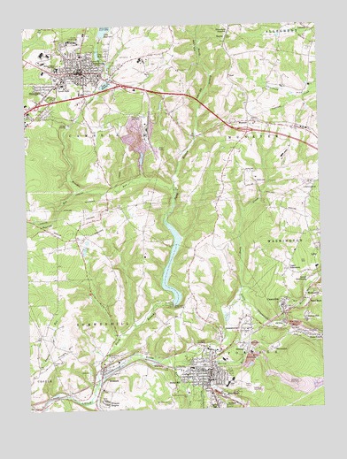
Ebensburg, PA USGS Topographic Map
Click on map above to begin viewing in our Map Viewer.

This topographic map contains these locations and features:
Feature Name Type Latitude Longitude GNIS ID View Map
Appledale Public Golf CourseLocaleN40.4787°W78.7309°1205597View Map
Bens CreekPopulated PlaceN40.3984°W78.6278°1169262View Map
Bens CreekStreamN40.4026°W78.6420°1169264View Map
Bishop Carroll High SchoolSchoolN40.4862°W78.7359°1169670View Map
Borough of CassandraCivilN40.4085°W78.6407°1215012View Map
Borough of EbensburgCivilN40.4884°W78.7264°1215018View Map
Borough of PortageCivilN40.3869°W78.6747°1215031View Map
Borough of WilmoreCivilN40.3876°W78.7171°1215039View Map
Cambria CountyCivilN40.4953°W78.7137°1213662View Map
Cambria County FairgroundLocaleN40.3965°W78.7261°1213451View Map
Cambria County HomeBuildingN40.4890°W78.7000°1209104View Map
Cambria County SheriffBuildingN40.4839°W78.7245°2780312View Map
Cambria Slope Mine Number Thirty-Three DamDamN40.4634°W78.7031°1194830View Map
CassandraPopulated PlaceN40.4087°W78.6406°1198271View Map
Cassandra Post OfficePost OfficeN40.4085°W78.6403°2772625View Map
Cassandra Volunteer Fire CompanyBuildingN40.4078°W78.6403°2645601View Map
City Reservoir Number OneReservoirN40.4910°W78.7183°1171886View Map
City Reservoir Number TwoReservoirN40.4985°W78.7155°1194855View Map
Crichton McCormick ParkParkN40.3804°W78.6820°1172693View Map
Dauntless Volunteer Fire Company Station 22BuildingN40.4863°W78.7264°2645116View Map
EbensburgPopulated PlaceN40.4851°W78.7247°1173958View Map
Ebensburg Area Ambulance Association Station 48BuildingN40.4840°W78.7323°2719522View Map
Ebensburg Borough Police DepartmentBuildingN40.4850°W78.7273°2780210View Map
Ebensburg JunctionPopulated PlaceN40.4990°W78.6614°1203487View Map
Ebensburg Post OfficePost OfficeN40.4859°W78.7252°2772684View Map
Ebensburg Storage DamReservoirN40.4900°W78.7180°1194833View Map
Hamilton Hill AirportAirportN40.4284°W78.7401°2443009View Map
Holy Name CemeteryCemeteryN40.4786°W78.7378°1177278View Map
Howells RunStreamN40.4470°W78.6867°1192642View Map
Howells Run DamDamN40.4934°W78.7197°1194856View Map
JamestownPopulated PlaceN40.4045°W78.6553°1177979View Map
Kane RunStreamN40.3917°W78.6909°1198958View Map
KaylorPopulated PlaceN40.4962°W78.6628°1203915View Map
Kaylor HollowValleyN40.4646°W78.6766°1178260View Map
Kimball HeliportAirportN40.4923°W78.7322°1213780View Map
Krug Airport (historical)AirportN40.4667°W78.6331°1209138View Map
Lake RowenaReservoirN40.4808°W78.7151°1185577View Map
Lake Rowena Recreation DamDamN40.4867°W78.7147°1194850View Map
Lloyd CemeteryCemeteryN40.4866°W78.7109°1179733View Map
Lovell ParkPopulated PlaceN40.4801°W78.6670°1209108View Map
Lovell ParkParkN40.4806°W78.7359°1179992View Map
Lower DutchtownPopulated PlaceN40.4173°W78.6292°1180014View Map
Miller ShaftPopulated PlaceN40.3792°W78.6628°1204180View Map
MoshannonPopulated PlaceN40.4117°W78.6259°1181609View Map
Moudy HillPopulated PlaceN40.3815°W78.6895°1199192View Map
MunsterPopulated PlaceN40.4684°W78.6542°1182099View Map
Mylo ParkPopulated PlaceN40.4801°W78.7425°1198293View Map
Mylo SchoolSchoolN40.4834°W78.7353°1182142View Map
MyraLocaleN40.4001°W78.6414°1205205View Map
NoelPopulated PlaceN40.4831°W78.6622°1182495View Map
Noels CreekStreamN40.4145°W78.6584°1182496View Map
North Branch Little Conemaugh RiverStreamN40.3834°W78.7203°1198101View Map
Oil CityPopulated PlaceN40.4023°W78.6400°1182886View Map
Pennsylvania Conservation and Natural Resources District 6 GallitzinBuildingN40.4930°W78.7337°2645825View Map
Pennsylvania State PoliceBuildingN40.4723°W78.7484°1209105View Map
Plane BankPopulated PlaceN40.4092°W78.6297°1183993View Map
Pond Number OneReservoirN40.4634°W78.7050°1194831View Map
PortagePopulated PlaceN40.3887°W78.6722°1184289View Map
Portage Area Ambulance Association Station 89BuildingN40.3892°W78.6710°2719632View Map
Portage Post OfficePost OfficeN40.3873°W78.6730°2772921View Map
Portage Volunteer Fire Company Station 83BuildingN40.3860°W78.6727°2645480View Map
Pringle HillSummitN40.3942°W78.7325°1184426View Map
Pringle Hill CemeteryCemeteryN40.3916°W78.7394°1184427View Map
Prospect CemeteryCemeteryN40.3800°W78.6740°1829099View Map
RedbirdPopulated PlaceN40.3773°W78.6620°1184801View Map
Roaring RunStreamN40.4473°W78.7256°1198115View Map
Sacred Heart CemeteryCemeteryN40.3787°W78.6737°1829101View Map
Saint Bartholomew CemeteryCemeteryN40.3938°W78.7105°1185808View Map
Saint Mary's CemeteryCemeteryN40.3792°W78.6737°1829100View Map
Saints Peter and Paul CemeteryCemeteryN40.3773°W78.6890°1186800View Map
Sanders RunStreamN40.4465°W78.7103°1201512View Map
Sanders RunStreamN40.4504°W78.6995°1186936View Map
Scarlan HillPopulated PlaceN40.4040°W78.6320°1187060View Map
ShoemakerPopulated PlaceN40.3942°W78.6459°1204642View Map
SonmanPopulated PlaceN40.3951°W78.6592°1204685View Map
Spring HillPopulated PlaceN40.3765°W78.6700°1188232View Map
Spring RunStreamN40.3962°W78.6731°1188257View Map
Township of CambriaCivilN40.4931°W78.7448°1216075View Map
Township of MunsterCivilN40.4635°W78.6564°1216090View Map
Township of PortageCivilN40.3788°W78.6415°1216091View Map
Trout RunStreamN40.3884°W78.6886°1189863View Map
Upper DutchtownPopulated PlaceN40.4201°W78.6386°1190233View Map
WAJE-AM (Ebensburg)TowerN40.4926°W78.7147°1200420View Map
WilmorePopulated PlaceN40.3887°W78.7186°1191523View Map
Wilmore DamDamN40.4084°W78.6864°1194790View Map
Wilmore DamDamN40.4096°W78.6881°1191524View Map
Wilmore HeightsPopulated PlaceN40.3779°W78.7159°1191525View Map
Wilmore Post OfficePost OfficeN40.3875°W78.7182°2779777View Map
Wilmore Volunteer Fire CompanyBuildingN40.3877°W78.7189°2644785View Map
WRML-AM (Portage)TowerN40.3826°W78.6578°1200408View Map

Note: Coordinates in the location and feature list above are referenced to NAD83 datum.


Copyright (C) 2008-2025 Ryan Niemi / Sunset Dynamics ... All Rights Reserved