TopoQuest Logo
Do you find TopoQuest useful?
Help keep TopoQuest running and adding new maps/features by donating!
Bitcoin:  19c7KJd3qBynnjoSw5npx9KScwjBe4ifkT
Litecoin:  LXs6TkuXGGXo1vDsWCkWVdjQX94eUKd6ui
Home View Maps Find Maps Find Places Resources & Links


Nanty Glo, Pennsylvania Topographic Map

USGS Map Title: Nanty Glo, PA
USGS Map MRC: 40078D7
DRG (GeoTIFF) Download: o40078d7.tif


Neighboring USGS Topographic Map Quads:


  Strongstown, PA  
40078E8
 

  Colver, PA  
40078E7
 

  Carrolltown, PA  
40078E6
 

  Vintondale, PA  
40078D8
 

  Nanty Glo, PA  
40078D7
 

  Ebensburg, PA  
40078D6
 

  Johnstown, PA  
40078C8
 

  Geistown, PA  
40078C7
 

  Beaverdale, PA  
40078C6


Map MRC Location:

N41°
W79°
N41°
W78°
H8 H7 H6 H5 H4 H3 H2 H1
G8 G7 G6 G5 G4 G3 G2 G1
F8 F7 F6 F5 F4 F3 F2 F1
E8 E7 E6 E5 E4 E3 E2 E1
D8 D7 D6 D5 D4 D3 D2 D1
C8 C7 C6 C5 C4 C3 C2 C1
B8 B7 B6 B5 B4 B3 B2 B1
A8 A7 A6 A5 A4 A3 A2 A1
N40°
W79°
N40°
W78°

Nanty Glo, PA USGS 1:24K Topographic Map Preview:
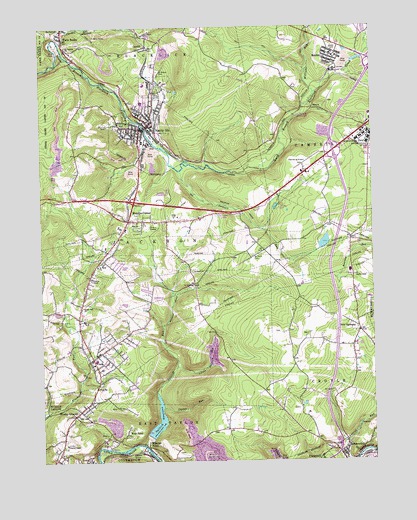
Nanty Glo, PA USGS Topographic Map
Click on map above to begin viewing in our Map Viewer.

This topographic map contains these locations and features:
Feature Name Type Latitude Longitude GNIS ID View Map
BeulaPopulated PlaceN40.4767°W78.7720°1203082View Map
Big Bend SchoolSchoolN40.4998°W78.8661°1169482View Map
Blacklick Valley Foundation and Ambulance Service Station 46BuildingN40.4721°W78.8356°2719526View Map
Borough of Nanty-GloCivilN40.4708°W78.8339°1215029View Map
Borough of SummerhillCivilN40.3764°W78.7616°2086657View Map
Cambria Township Police DepartmentBuildingN40.4961°W78.7545°2780205View Map
CardiffPopulated PlaceN40.4951°W78.8339°1171201View Map
Clear Spring Lake DamDamN40.4981°W78.7519°2495717View Map
Coalpit RunStreamN40.4965°W78.8675°1172085View Map
Custer RunStreamN40.3906°W78.8289°1172872View Map
DearminLocaleN40.4517°W78.8431°1201175View Map
Ebensburg AirportAirportN40.4594°W78.7750°1193993View Map
Ebensburg State SchoolSchoolN40.4698°W78.7528°1173959View Map
EchoPopulated PlaceN40.3770°W78.8575°1173964View Map
Greater Johnstown Water Authority DamDamN40.3823°W78.8344°1194770View Map
Jackson Township Police DepartmentBuildingN40.4442°W78.8400°2780557View Map
Jackson Township Volunteer Fire Company Station 42BuildingN40.4058°W78.8543°2644985View Map
Little Saltlick RunStreamN40.4023°W78.8239°1179666View Map
Mineral PointPopulated PlaceN40.3795°W78.8353°1181316View Map
Mineral Point Post OfficePost OfficeN40.3794°W78.8353°2779602View Map
Mundys CornerPopulated PlaceN40.4448°W78.8411°1182091View Map
Mundys Corner Census Designated PlaceCensusN40.4432°W78.8325°2630028View Map
Nanty GloPopulated PlaceN40.4723°W78.8334°1217365View Map
Nanty Glo Fire Department Station 43BuildingN40.4714°W78.8354°2645103View Map
Nanty Glo Police DepartmentBuildingN40.4715°W78.8349°2780512View Map
Nanty Glo Post OfficePost OfficeN40.4717°W78.8344°2779893View Map
New GermanyPopulated PlaceN40.4123°W78.7550°1182325View Map
Pennsylvania State Police Troop A Ebensburg StationBuildingN40.4610°W78.7554°2777313View Map
Pike ChurchChurchN40.4442°W78.8381°1183727View Map
RevlocPopulated PlaceN40.4923°W78.7642°1184954View Map
Revloc Census Designated PlaceCensusN40.4914°W78.7637°2633672View Map
Revloc Post OfficePost OfficeN40.4918°W78.7652°2779831View Map
Revloc Volunteer Fire Company Station 44BuildingN40.4920°W78.7643°2644932View Map
Saint Charles ChurchChurchN40.4948°W78.8647°1185869View Map
Saint Marys CemeteryCemeteryN40.4868°W78.8303°1186383View Map
Saint Pauls CemeteryCemeteryN40.4341°W78.7949°1186562View Map
Saint Pauls ChurchChurchN40.4317°W78.8531°1186598View Map
Saltlick ReservoirReservoirN40.3843°W78.8319°1186882View Map
Saltlick RunStreamN40.3801°W78.8364°1186884View Map
Singer Hill ChurchChurchN40.4201°W78.8592°1187709View Map
Stewart RunStreamN40.4590°W78.8222°1188649View Map
SummerhillPopulated PlaceN40.3781°W78.7606°1189026View Map
Summerhill Borough Fire Department Station 86BuildingN40.3758°W78.7603°2645252View Map
Summit ChapelChurchN40.3801°W78.8656°1189041View Map
Township of JacksonCivilN40.4324°W78.8742°1216085View Map
Twin RocksPopulated PlaceN40.4967°W78.8659°1190013View Map
Twin Rocks Post OfficePost OfficeN40.4989°W78.8659°1201176View Map
VincoPopulated PlaceN40.4051°W78.8556°1190430View Map
Vinco Census Designated PlaceCensusN40.4111°W78.8446°2390439View Map
Vinco Post Office (historical)Post OfficeN40.4051°W78.8556°1201174View Map
Wesley ChapelPopulated PlaceN40.3887°W78.8622°1190858View Map
West PointPopulated PlaceN40.3831°W78.8434°1191097View Map
Williams RunStreamN40.4815°W78.7709°1193672View Map
WIYQ-FM (Ebensburg)TowerN40.4115°W78.7745°1200221View Map

Note: Coordinates in the location and feature list above are referenced to NAD83 datum.


Copyright (C) 2008-2025 Ryan Niemi / Sunset Dynamics ... All Rights Reserved