TopoQuest Logo
Do you find TopoQuest useful?
Help keep TopoQuest running and adding new maps/features by donating!
Bitcoin:  19c7KJd3qBynnjoSw5npx9KScwjBe4ifkT
Litecoin:  LXs6TkuXGGXo1vDsWCkWVdjQX94eUKd6ui
Home View Maps Find Maps Find Places Resources & Links


Edinburg, Illinois Topographic Map

USGS Map Title: Edinburg, IL
USGS Map MRC: 39089F4
DRG (GeoTIFF) Download: o39089f4.tif


Neighboring USGS Topographic Map Quads:


  Springfield East, IL  
39089G5
 

  Mechanicsburg, IL  
39089G4
 

  Mount Auburn, IL  
39089G3
 

  New City, IL  
39089F5
 

  Edinburg, IL  
39089F4
 

  Grove City, IL  
39089F3
 

  Pawnee, IL  
39089E5
 

  Kincaid, IL  
39089E4
 

  Taylorville, IL  
39089E3


Map MRC Location:

N40°
W90°
N40°
W89°
H8 H7 H6 H5 H4 H3 H2 H1
G8 G7 G6 G5 G4 G3 G2 G1
F8 F7 F6 F5 F4 F3 F2 F1
E8 E7 E6 E5 E4 E3 E2 E1
D8 D7 D6 D5 D4 D3 D2 D1
C8 C7 C6 C5 C4 C3 C2 C1
B8 B7 B6 B5 B4 B3 B2 B1
A8 A7 A6 A5 A4 A3 A2 A1
N39°
W90°
N39°
W89°

Edinburg, IL USGS 1:24K Topographic Map Preview:
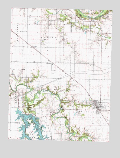
Edinburg, IL USGS Topographic Map
Click on map above to begin viewing in our Map Viewer.

This topographic map contains these locations and features:
Feature Name Type Latitude Longitude GNIS ID View Map
American School (historical)SchoolN39.7287°W89.4348°403485View Map
BerryPopulated PlaceN39.7131°W89.4709°1821036View Map
Berry Oil FieldOilfieldN39.7284°W89.4559°1736850View Map
BluevillePopulated PlaceN39.6623°W89.3920°1811210View Map
BreckenridgePopulated PlaceN39.6989°W89.4476°422497View Map
Breckenridge CemeteryCemeteryN39.6906°W89.4854°1736851View Map
BuckhartPopulated PlaceN39.7498°W89.4448°405120View Map
Camelsburg School (historical)SchoolN39.6837°W89.4223°405426View Map
Campbellsburg (historical)Populated PlaceN39.6837°W89.4204°1811214View Map
CascadePopulated PlaceN39.6703°W89.4920°422532View Map
Cascade School (historical)SchoolN39.6845°W89.4926°405670View Map
Clear CreekStreamN39.6481°W89.4759°406201View Map
Clear CreekStreamN39.6612°W89.4781°406207View Map
Cooper School (historical)SchoolN39.7217°W89.3879°406556View Map
Deer Run CampgroundLocaleN39.6537°W89.4698°1811221View Map
EdinburgPopulated PlaceN39.6573°W89.3895°407786View Map
Edinburg CemeteryCemeteryN39.6631°W89.3998°1953216View Map
Edinburg Fire Protection DistrictBuildingN39.6582°W89.3898°2640390View Map
Edinburg High SchoolSchoolN39.6603°W89.3881°1811222View Map
Edinburg Police DepartmentBuildingN39.6569°W89.3910°2758950View Map
Edinburg Post OfficePost OfficeN39.6574°W89.3885°2788266View Map
Edinburg West Oil FieldOilfieldN39.6567°W89.4623°1747890View Map
Finley CemeteryCemeteryN39.6345°W89.4645°1747892View Map
Furrow CemeteryCemeteryN39.7445°W89.4195°1747893View Map
George School (historical)SchoolN39.6848°W89.3909°408951View Map
Greenwood School (historical)SchoolN39.6264°W89.4259°409469View Map
Greer School (historical)SchoolN39.6334°W89.4518°409477View Map
Harts Park (historical)LocaleN39.7462°W89.3834°409891View Map
Hickory Point CampgroundLocaleN39.6437°W89.4629°1811235View Map
Hundley AirportAirportN39.7118°W89.4890°2717717View Map
Liberty School (historical)SchoolN39.6370°W89.3873°412025View Map
Martin School (historical)SchoolN39.6845°W89.4576°413076View Map
Oak Hill CemeteryCemeteryN39.7406°W89.4437°1736889View Map
Pheasant Run Access AreaParkN39.6292°W89.4545°1811251View Map
RobyPopulated PlaceN39.7392°W89.3993°416782View Map
Roby Post Office (historical)Post OfficeN39.7384°W89.3995°1811253View Map
Sangchris Lake DamDamN39.6487°W89.4765°1691798View Map
Sangchris Lake State ParkParkN39.6509°W89.4726°1736898View Map
Star School (historical)SchoolN39.6550°W89.4245°419048View Map
Sudduth School (historical)SchoolN39.7387°W89.3879°419252View Map
Taft Airport (historical)AirportN39.7417°W89.4771°427743View Map
Taylor CemeteryCemeteryN39.6595°W89.4801°1736907View Map
Tommy's AirparkAirportN39.6482°W89.4579°2679045View Map
Township of CooperCivilN39.7451°W89.4374°428840View Map
Village of EdinburgCivilN39.6579°W89.3901°2398786View Map

Note: Coordinates in the location and feature list above are referenced to NAD83 datum.


Copyright (C) 2008-2025 Ryan Niemi / Sunset Dynamics ... All Rights Reserved