TopoQuest Logo
Do you find TopoQuest useful?
Help keep TopoQuest running and adding new maps/features by donating!
Bitcoin:  19c7KJd3qBynnjoSw5npx9KScwjBe4ifkT
Litecoin:  LXs6TkuXGGXo1vDsWCkWVdjQX94eUKd6ui
Home View Maps Find Maps Find Places Resources & Links


Pawnee, Illinois Topographic Map

USGS Map Title: Pawnee, IL
USGS Map MRC: 39089E5
DRG (GeoTIFF) Download: o39089e5.tif


Neighboring USGS Topographic Map Quads:


  Chatham, IL  
39089F6
 

  New City, IL  
39089F5
 

  Edinburg, IL  
39089F4
 

  Divernon, IL  
39089E6
 

  Pawnee, IL  
39089E5
 

  Kincaid, IL  
39089E4
 

  Farmersville, IL  
39089D6
 

  Raymond NE, IL  
39089D5
 

  Morrisonville, IL  
39089D4


Map MRC Location:

N40°
W90°
N40°
W89°
H8 H7 H6 H5 H4 H3 H2 H1
G8 G7 G6 G5 G4 G3 G2 G1
F8 F7 F6 F5 F4 F3 F2 F1
E8 E7 E6 E5 E4 E3 E2 E1
D8 D7 D6 D5 D4 D3 D2 D1
C8 C7 C6 C5 C4 C3 C2 C1
B8 B7 B6 B5 B4 B3 B2 B1
A8 A7 A6 A5 A4 A3 A2 A1
N39°
W90°
N39°
W89°

Pawnee, IL USGS 1:24K Topographic Map Preview:
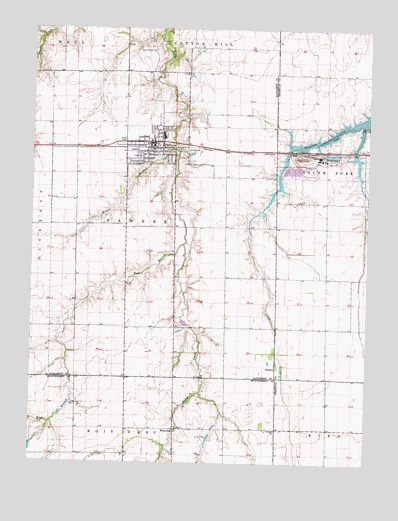
Pawnee, IL USGS Topographic Map
Click on map above to begin viewing in our Map Viewer.

This topographic map contains these locations and features:
Feature Name Type Latitude Longitude GNIS ID View Map
Beaverdam School (historical)SchoolN39.5464°W89.5712°1736847View Map
Butler School (historical)SchoolN39.5751°W89.5015°1747879View Map
Calvary CemeteryCemeteryN39.5903°W89.5687°405391View Map
Commanche VillagePopulated PlaceN39.5923°W89.6220°1821051View Map
Donald A. Hamilton AirportAirportN39.5920°W89.6003°427650View Map
EllisPopulated PlaceN39.5901°W89.5290°422664View Map
Fry RLA Airport (historical)AirportN39.5862°W89.5487°427652View Map
Henkle BranchStreamN39.5901°W89.5720°410055View Map
Hopewell School (historical)SchoolN39.5684°W89.5348°1736870View Map
Horse Creek CemeteryCemeteryN39.6187°W89.5787°410557View Map
Kentucky School (historical)SchoolN39.5759°W89.6084°1736872View Map
Lynndora School (historical)SchoolN39.5392°W89.5354°1736875View Map
Murphy School (historical)SchoolN39.5020°W89.6084°1772118View Map
PawneePopulated PlaceN39.5917°W89.5804°415465View Map
Pawnee Fire Protection DistrictBuildingN39.5921°W89.5829°2640854View Map
Pawnee Grade SchoolSchoolN39.5948°W89.5765°1821096View Map
Pawnee High SchoolSchoolN39.5939°W89.5762°1821097View Map
Pawnee Police DepartmentBuildingN39.5915°W89.5813°2758987View Map
Pawnee Post OfficePost OfficeN39.5916°W89.5787°2788293View Map
Pleasant Hill School (historical)SchoolN39.5962°W89.5084°1747924View Map
Saint Marys ChurchChurchN39.5926°W89.5801°1962314View Map
Sanders School (historical)SchoolN39.6001°W89.5520°1736897View Map
Shiloh School (historical)SchoolN39.5095°W89.5054°1747931View Map
Slurry Impoundment Number 1 DamDamN39.5851°W89.5201°1692189View Map
Slurry Impoundment Number 1 ReservoirReservoirN39.5851°W89.5201°1692190View Map
Township of PawneeCivilN39.5684°W89.5762°429534View Map
United Methodist Church of PawneeChurchN39.5895°W89.5804°1962318View Map
Village of PawneeCivilN39.5936°W89.5825°2399635View Map
West Branch Horse CreekStreamN39.5631°W89.5684°420787View Map
White OakPopulated PlaceN39.5098°W89.5712°423305View Map
ZenobiaPopulated PlaceN39.5287°W89.5337°423347View Map
Zenobia ChurchChurchN39.5098°W89.5334°421615View Map

Note: Coordinates in the location and feature list above are referenced to NAD83 datum.


Copyright (C) 2008-2025 Ryan Niemi / Sunset Dynamics ... All Rights Reserved