TopoQuest Logo
Do you find TopoQuest useful?
Help keep TopoQuest running and adding new maps/features by donating!
Bitcoin:  19c7KJd3qBynnjoSw5npx9KScwjBe4ifkT
Litecoin:  LXs6TkuXGGXo1vDsWCkWVdjQX94eUKd6ui
Home View Maps Find Maps Find Places Resources & Links


Edmonds West, Washington Topographic Map

USGS Map Title: Edmonds West, WA
USGS Map MRC: 47122G4
DRG (GeoTIFF) Download: o47122g4.tif


Neighboring USGS Topographic Map Quads:


  Hansville, WA  
47122H5
 

  Maxwelton, WA  
47122H4
 

  Mukilteo, WA  
47122H3
 

  Port Gamble, WA  
47122G5
 

  Edmonds West, WA  
47122G4
 

  Edmonds East, WA  
47122G3
 

  Suquamish, WA  
47122F5


Map MRC Location:

N48°
W123°
N48°
W122°
H8 H7 H6 H5 H4 H3 H2 H1
G8 G7 G6 G5 G4 G3 G2 G1
F8 F7 F6 F5 F4 F3 F2 F1
E8 E7 E6 E5 E4 E3 E2 E1
D8 D7 D6 D5 D4 D3 D2 D1
C8 C7 C6 C5 C4 C3 C2 C1
B8 B7 B6 B5 B4 B3 B2 B1
A8 A7 A6 A5 A4 A3 A2 A1
N47°
W123°
N47°
W122°

Edmonds West, WA USGS 1:24K Topographic Map Preview:
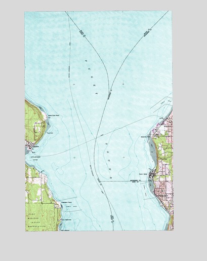
Edmonds West, WA USGS Topographic Map
Click on map above to begin viewing in our Map Viewer.

This topographic map contains these locations and features:
Feature Name Type Latitude Longitude GNIS ID View Map
Apple Cove PointCapeN47.8157°W122.4832°1503044View Map
Apple Cove Point LightLocaleN47.8145°W122.4815°1531718View Map
Appletree CoveBayN47.7904°W122.4962°1503045View Map
Chevron Hill Tank FarmLocaleN47.7822°W122.3944°2706081View Map
City of Edmonds Fire Department Administration OfficeBuildingN47.8114°W122.3771°2619759View Map
City of Edmonds Fire Department Station 17BuildingN47.8125°W122.3753°2619796View Map
City of Edmonds Fire MarshalBuildingN47.8114°W122.3772°2619370View Map
City of WoodwayCivilN47.7932°W122.4082°2412307View Map
Deer CreekStreamN47.7909°W122.3910°1504410View Map
EdmondsPopulated PlaceN47.8107°W122.3774°1512180View Map
Edmonds City HallBuildingN47.8113°W122.3770°2610589View Map
Edmonds CourthouseBuildingN47.8115°W122.3753°2610507View Map
Edmonds Ferry LandingLocaleN47.8129°W122.3841°2608110View Map
Edmonds Historical MuseumBuildingN47.8110°W122.3767°2610446View Map
Edmonds Junior High SchoolSchoolN47.8145°W122.3754°1511884View Map
Edmonds Police DepartmentBuildingN47.8118°W122.3752°2605444View Map
Edmonds Post OfficePost OfficeN47.8119°W122.3803°2462217View Map
Edmonds StationLocaleN47.8111°W122.3843°2605460View Map
Edmonds Underwater ParkParkN47.8137°W122.3846°1514165View Map
Edmonds Wastewater Treatment PlantLocaleN47.8091°W122.3825°2610666View Map
Edmonds Yacht ClubLocaleN47.8099°W122.3892°2610345View Map
Edwards PointCapeN47.8032°W122.3949°1504690View Map
First Church of Christ ScientistChurchN47.8091°W122.3754°2609970View Map
Horizon SchoolSchoolN47.7711°W122.3778°2605918View Map
KingstonPopulated PlaceN47.7987°W122.4982°1512350View Map
Kingston Census Designated PlaceCensusN47.8011°W122.4986°2408487View Map
Kingston Christian ChurchChurchN47.8002°W122.4980°2608949View Map
Kingston Ferry LandingLocaleN47.7953°W122.4957°2608114View Map
Kingston LibraryBuildingN47.7989°W122.4979°2610131View Map
Kingston Senior Community CenterBuildingN47.7988°W122.4979°2608296View Map
Newellhurst CreekStreamN47.7831°W122.4892°2359651View Map
North Sound ChurchChurchN47.8117°W122.3774°2608891View Map
Osier CreekStreamN47.7861°W122.4950°2359652View Map
Parker PlazaLocaleN47.8098°W122.3896°1513758View Map
Point WellsCapeN47.7820°W122.3974°1507540View Map
Port of EdmondsLocaleN47.8084°W122.3899°1514341View Map
Port of Kingston MarinaLocaleN47.7952°W122.4985°2610369View Map
President PointCapeN47.7659°W122.4721°1507626View Map
Puget SoundBayN47.8332°W122.4346°1507653View Map
Richmond BeachPopulated PlaceN47.7695°W122.3901°1512601View Map
Richmond Beach Congregational ChurchChurchN47.7710°W122.3779°2609069View Map
Richmond Beach LibraryBuildingN47.7713°W122.3842°2461277View Map
Richmond Beach Rehabilitation CenterBuildingN47.7694°W122.3784°2607924View Map
Shelleberger CreekStreamN47.8065°W122.3821°1508286View Map
Shoreline Fire Department Station 62BuildingN47.7704°W122.3821°2767945View Map
Sno-King Lutheran SchoolSchoolN47.8143°W122.3757°1515069View Map
Sunset BeachBeachN47.8145°W122.3810°1514486View Map
Unity ChurchChurchN47.7987°W122.4962°2609562View Map
Washington Pacific Churches of the NazareneChurchN47.8093°W122.3851°2609181View Map
Whisper CreekStreamN47.7956°W122.4961°2355700View Map
WoodwayPopulated PlaceN47.7962°W122.3829°1512815View Map
Woodway Police DepartmentBuildingN47.7817°W122.3852°2722084View Map

Note: Coordinates in the location and feature list above are referenced to NAD83 datum.


Copyright (C) 2008-2024 Ryan Niemi / Sunset Dynamics ... All Rights Reserved