TopoQuest Logo
Do you find TopoQuest useful?
Help keep TopoQuest running and adding new maps/features by donating!
Bitcoin:  19c7KJd3qBynnjoSw5npx9KScwjBe4ifkT
Litecoin:  LXs6TkuXGGXo1vDsWCkWVdjQX94eUKd6ui
Home View Maps Find Maps Find Places Resources & Links


Port Gamble, Washington Topographic Map

USGS Map Title: Port Gamble, WA
USGS Map MRC: 47122G5
DRG (GeoTIFF) Download: o47122g5.tif


Neighboring USGS Topographic Map Quads:


  Port Ludlow, WA  
47122H6
 

  Hansville, WA  
47122H5
 

  Maxwelton, WA  
47122H4
 

  Lofall, WA  
47122G6
 

  Port Gamble, WA  
47122G5
 

  Edmonds West, WA  
47122G4
 

  Poulsbo, WA  
47122F6
 

  Suquamish, WA  
47122F5


Map MRC Location:

N48°
W123°
N48°
W122°
H8 H7 H6 H5 H4 H3 H2 H1
G8 G7 G6 G5 G4 G3 G2 G1
F8 F7 F6 F5 F4 F3 F2 F1
E8 E7 E6 E5 E4 E3 E2 E1
D8 D7 D6 D5 D4 D3 D2 D1
C8 C7 C6 C5 C4 C3 C2 C1
B8 B7 B6 B5 B4 B3 B2 B1
A8 A7 A6 A5 A4 A3 A2 A1
N47°
W123°
N47°
W122°

Port Gamble, WA USGS 1:24K Topographic Map Preview:
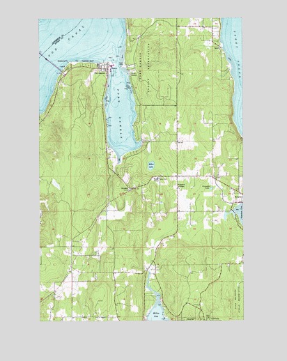
Port Gamble, WA USGS Topographic Map
Click on map above to begin viewing in our Map Viewer.

This topographic map contains these locations and features:
Feature Name Type Latitude Longitude GNIS ID View Map
Bayside Community ChurchChurchN47.7993°W122.5082°2609556View Map
Buena Vista CemeteryCemeteryN47.8558°W122.5870°2605486View Map
Calvary Chapel PoulsboChurchN47.7761°W122.6061°2609800View Map
Carpenter CreekStreamN47.7948°W122.5118°1926879View Map
Carpenter LakeLakeN47.8044°W122.5206°1503819View Map
Courtenay DamDamN47.7932°W122.5162°1532668View Map
Crabapple CreekStreamN47.7911°W122.5117°2355697View Map
David Wolfle Elementary SchoolSchoolN47.8074°W122.5534°1531198View Map
EglonPopulated PlaceN47.8626°W122.5146°1512182View Map
Eglon Community ChurchChurchN47.8682°W122.5190°2609557View Map
Faith Evangelical Lutheran ChurchChurchN47.8051°W122.5409°2609558View Map
Fukuzawa CreekStreamN47.8050°W122.5150°2359650View Map
George's Corners Park and RideLocaleN47.8124°W122.5397°2608155View Map
Georges CornerLocaleN47.8095°W122.5415°1511895View Map
Hansville LandfillLocaleN47.8494°W122.5468°2605577View Map
Hood Canal BridgeBridgeN47.8593°W122.6232°1510016View Map
Indianola Census Designated PlaceCensusN47.7555°W122.5143°2408424View Map
Indianola Foursquare ChurchChurchN47.7509°W122.5206°2609548View Map
Kingdom Hall of Jehovahs WitnessesChurchN47.7512°W122.5836°2609803View Map
Kingfisher CreekStreamN47.7922°W122.5061°2355698View Map
Kingston CemeteryCemeteryN47.7938°W122.5192°2605499View Map
Kingston CreekStreamN47.7975°W122.5031°2355699View Map
Kingston DivisionCivilN47.8499°W122.5250°1939531View Map
Kingston GrangeLocaleN47.8051°W122.5410°1505990View Map
Kingston High SchoolSchoolN47.8001°W122.5201°2606556View Map
Kingston Junior High SchoolSchoolN47.8020°W122.5007°1515287View Map
Kingston Missionary ChurchChurchN47.8188°W122.5408°2609559View Map
Kingston Post OfficePost OfficeN47.8030°W122.5018°2606962View Map
Kitsap County Kingston Wastewater Treatment PlantLocaleN47.7726°W122.5068°2610683View Map
Little BostonPopulated PlaceN47.8523°W122.5701°1511101View Map
Little Boston LibraryBuildingN47.8525°W122.5697°2610132View Map
Maple Tree CornerLocaleN47.7951°W122.5415°1511932View Map
Miller BayBayN47.7521°W122.5537°1506701View Map
Miller Bay QuarryMineN47.7742°W122.5548°2605738View Map
Miller LakeLakeN47.8139°W122.5575°1506707View Map
North Kitsap County Fire and Rescue Eglon StationBuildingN47.8691°W122.5201°2619664View Map
North Kitsap Fire and Rescue Station 81 HeadquartersBuildingN47.8044°W122.5404°2606067View Map
North Kitsap Fire and Rescue Station 85 South KingstonBuildingN47.7726°W122.5072°2643505View Map
North Kitsap Fire and Rescue Station 87BuildingN47.8708°W122.5420°2767935View Map
Point JuliaCapeN47.8551°W122.5757°1507527View Map
Port GambleHarborN47.8393°W122.5757°1531825View Map
Port GambleBayN47.8368°W122.5768°1507566View Map
Port GamblePopulated PlaceN47.8543°W122.5838°1512577View Map
Port Gamble Historic MuseumBuildingN47.8558°W122.5836°2610480View Map
Port Gamble Post OfficePost OfficeN47.8557°W122.5845°2781613View Map
Port Gamble ReservationCivilN47.8474°W122.5576°1507567View Map
Port Gamble S'Klallam Daycare CenterSchoolN47.8533°W122.5689°2606137View Map
Port Gamble S'Klallam Police DepartmentBuildingN47.8526°W122.5679°2768884View Map
Port Gamble S'Klallam Tribe Senior CenterBuildingN47.8521°W122.5692°2608297View Map
Port Gamble Tribal Community Census Designated PlaceCensusN47.8493°W122.5579°2585020View Map
Redeemer United Methodist ChurchChurchN47.8104°W122.5181°2609560View Map
Richard Gordon Elementary SchoolSchoolN47.8027°W122.5164°2606519View Map
Rose PointPopulated PlaceN47.8548°W122.5096°1531663View Map
S'Klallam Worship CenterChurchN47.8556°W122.5670°2609561View Map
Salsbury PointCapeN47.8565°W122.6079°1508059View Map
Silver CreekStreamN47.8632°W122.5290°1514894View Map
Spectrum Community SchoolSchoolN47.7966°W122.5164°2606430View Map
Striebels CornerPopulated PlaceN47.8048°W122.5682°1511342View Map
Teekalet BluffCliffN47.8565°W122.5951°1508932View Map
Thompson AirportAirportN47.7986°W122.5300°2443377View Map
White Horse Golf ClubLocaleN47.7689°W122.5299°2608210View Map

Note: Coordinates in the location and feature list above are referenced to NAD83 datum.


Copyright (C) 2008-2024 Ryan Niemi / Sunset Dynamics ... All Rights Reserved