TopoQuest Logo
Do you find TopoQuest useful?
Help keep TopoQuest running and adding new maps/features by donating!
Bitcoin:  19c7KJd3qBynnjoSw5npx9KScwjBe4ifkT
Litecoin:  LXs6TkuXGGXo1vDsWCkWVdjQX94eUKd6ui
Home View Maps Find Maps Find Places Resources & Links


Hansville, Washington Topographic Map

USGS Map Title: Hansville, WA
USGS Map MRC: 47122H5
DRG (GeoTIFF) Download: o47122h5.tif


Neighboring USGS Topographic Map Quads:


  Nordland, WA  
48122A6
 

  Freeland, WA  
48122A5
 

  Langley, WA  
48122A4
 

  Port Ludlow, WA  
47122H6
 

  Hansville, WA  
47122H5
 

  Maxwelton, WA  
47122H4
 

  Lofall, WA  
47122G6
 

  Port Gamble, WA  
47122G5
 

  Edmonds West, WA  
47122G4


Map MRC Location:

N48°
W123°
N48°
W122°
H8 H7 H6 H5 H4 H3 H2 H1
G8 G7 G6 G5 G4 G3 G2 G1
F8 F7 F6 F5 F4 F3 F2 F1
E8 E7 E6 E5 E4 E3 E2 E1
D8 D7 D6 D5 D4 D3 D2 D1
C8 C7 C6 C5 C4 C3 C2 C1
B8 B7 B6 B5 B4 B3 B2 B1
A8 A7 A6 A5 A4 A3 A2 A1
N47°
W123°
N47°
W122°

Hansville, WA USGS 1:24K Topographic Map Preview:
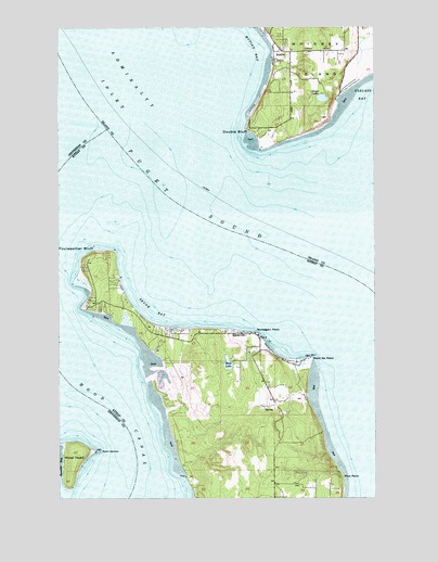
Hansville, WA USGS Topographic Map
Click on map above to begin viewing in our Map Viewer.

This topographic map contains these locations and features:
Feature Name Type Latitude Longitude GNIS ID View Map
Admiralty InletChannelN47.9498°W122.6013°1515733View Map
AustinPopulated PlaceN47.9915°W122.5399°1511975View Map
Buck LakeLakeN47.9107°W122.5594°1503602View Map
Coon BayBayN47.9065°W122.5854°1513089View Map
Dahlman DamDamN47.9815°W122.5313°1532689View Map
Double BluffCliffN47.9729°W122.5513°1504517View Map
Double Bluff LightLocaleN47.9676°W122.5465°1510001View Map
Eglon CemeteryCemeteryN47.8782°W122.5318°2605483View Map
Foulweather BluffCliffN47.9395°W122.6127°1504994View Map
HansvillePopulated PlaceN47.9187°W122.5543°1512267View Map
Hansville CemeteryCemeteryN47.9079°W122.5445°2605484View Map
Hansville Census Designated PlaceCensusN47.9159°W122.5734°2584979View Map
Hansville Community ChurchChurchN47.9175°W122.5473°2609530View Map
Hansville Post OfficePost OfficeN47.9165°W122.5470°2606956View Map
Hood HeadIslandN47.8843°W122.6207°1505590View Map
Manette PenninsulaBarN47.8951°W122.5574°1514794View Map
Mirth AirportAirportN47.9387°W122.6079°2717107View Map
Mutiny BayBayN47.9943°W122.5580°1506911View Map
Mutiny Bay Boat LaunchLocaleN47.9932°W122.5414°2607966View Map
North Kitsap Fire and Rescue Station 89 HansvilleBuildingN47.9167°W122.5798°2643507View Map
Norwegian PointCapeN47.9184°W122.5476°1507117View Map
Oliver LakeLakeN47.9810°W122.5218°1507167View Map
Pilot PointCapeN47.8807°W122.5143°1507428View Map
Pilots CoveBayN47.8795°W122.5218°1514868View Map
Point HannonCapeN47.8870°W122.6104°1507521View Map
Point Hannon LightLocaleN47.8873°W122.6113°1513024View Map
Point No PointCapeN47.9120°W122.5260°1507530View Map
Point No Point LightLocaleN47.9123°W122.5268°1510000View Map
Races CoveBayN47.9109°W122.5860°1514923View Map
Raden DamDamN47.9881°W122.5379°1532666View Map
Skunk BayBayN47.9273°W122.5835°1508399View Map
Skunk Bay LightLocaleN47.9201°W122.5696°1531717View Map
Tahoma One Drop Zen MonasteryChurchN47.9809°W122.5335°2609037View Map
Twin SpitsBarN47.9268°W122.6132°1510607View Map
Twin SpitsPopulated PlaceN47.9265°W122.6110°1511715View Map
Twin Spits MarinaLocaleN47.9061°W122.5867°2610300View Map

Note: Coordinates in the location and feature list above are referenced to NAD83 datum.


Copyright (C) 2008-2025 Ryan Niemi / Sunset Dynamics ... All Rights Reserved