TopoQuest Logo
Do you find TopoQuest useful?
Help keep TopoQuest running and adding new maps/features by donating!
Bitcoin:  19c7KJd3qBynnjoSw5npx9KScwjBe4ifkT
Litecoin:  LXs6TkuXGGXo1vDsWCkWVdjQX94eUKd6ui
Home View Maps Find Maps Find Places Resources & Links


Edray, West Virginia Topographic Map

USGS Map Title: Edray, WV
USGS Map MRC: 38080C1
DRG (GeoTIFF) Download: o38080c1.tif


Neighboring USGS Topographic Map Quads:


  Sharp Knob, WV  
38080D2
 

  Mingo, WV  
38080D1
 

  Cass, WV  
38079D8
 

  Woodrow, WV  
38080C2
 

  Edray, WV  
38080C1
 

  Clover Lick, WV  
38079C8
 

  Hillsboro, WV  
38080B2
 

  Marlinton, WV  
38080B1
 

  Minnehaha Springs, WV  
38079B8


Map MRC Location:

N39°
W81°
N39°
W80°
H8 H7 H6 H5 H4 H3 H2 H1
G8 G7 G6 G5 G4 G3 G2 G1
F8 F7 F6 F5 F4 F3 F2 F1
E8 E7 E6 E5 E4 E3 E2 E1
D8 D7 D6 D5 D4 D3 D2 D1
C8 C7 C6 C5 C4 C3 C2 C1
B8 B7 B6 B5 B4 B3 B2 B1
A8 A7 A6 A5 A4 A3 A2 A1
N38°
W81°
N38°
W80°

Edray, WV USGS 1:24K Topographic Map Preview:
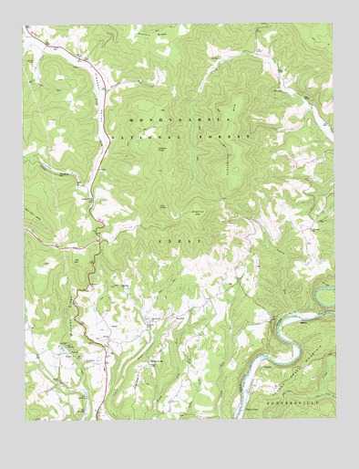
Edray, WV USGS Topographic Map
Click on map above to begin viewing in our Map Viewer.

This topographic map contains these locations and features:
Feature Name Type Latitude Longitude GNIS ID View Map
Averill SpringSpringN38.2718°W80.1060°1558058View Map
BrownsburgPopulated PlaceN38.2679°W80.0753°1558349View Map
Brownsburg School (historical)SchoolN38.2673°W80.0753°1728011View Map
Brushy Flat School (historical)SchoolN38.2637°W80.0606°1728013View Map
Central Union ChurchChurchN38.2560°W80.0670°1550667View Map
Chestnut FlatFlatN38.3154°W80.0551°1550690View Map
ClawsonPopulated PlaceN38.2685°W80.0301°1558353View Map
Clawson School (historical)SchoolN38.2612°W80.0270°1728029View Map
Cloverlick MountainSummitN38.3287°W80.0395°1558354View Map
Crooked ForkStreamN38.3254°W80.0984°1550839View Map
Crooked Fork School (historical)SchoolN38.3251°W80.0967°1728035View Map
Dry CreekStreamN38.2565°W80.0995°1550960View Map
EdrayPopulated PlaceN38.2746°W80.0915°1558358View Map
Edray DistrictCivilN38.3339°W80.1144°1928266View Map
Edray District High School (historical)SchoolN38.2662°W80.0928°1728054View Map
Edray School House (historical)SchoolN38.2718°W80.0915°1728056View Map
Edray Trout HatcheryLocaleN38.2779°W80.1087°1553627View Map
Edray United Methodist ChurchChurchN38.2701°W80.0920°1551021View Map
Elk MountainSummitN38.3007°W80.1020°1558360View Map
Fairview ChurchChurchN38.2815°W80.0259°1551082View Map
Fairview School (historical)SchoolN38.2823°W80.0262°1728058View Map
Gay KnobSummitN38.3176°W80.0703°1558363View Map
Gay Knob Fire Tower (historical)LocaleN38.3176°W80.0701°1728068View Map
Gibson CemeteryCemeteryN38.3679°W80.1126°1551225View Map
Hamlin United Methodist ChurchChurchN38.2623°W80.1123°1551339View Map
Hannah CemeteryCemeteryN38.3637°W80.1198°1551354View Map
Hannan SpringSpringN38.3543°W80.0192°1558103View Map
HarterPopulated PlaceN38.2810°W80.0126°1558367View Map
Laurel RunStreamN38.2826°W80.0162°1551724View Map
Marlin Lick RunStreamN38.2565°W80.0084°1552000View Map
Marys ChapelChurchN38.3646°W80.1020°1552008View Map
McLaughlin SpringSpringN38.2742°W80.1092°1558128View Map
Mill CreekStreamN38.3682°W80.1148°1552103View Map
Moffett KnobSummitN38.3354°W80.0712°1558375View Map
Mount Pleasant ChurchChurchN38.2812°W80.0748°1552215View Map
Mount Pleasant School (historical)SchoolN38.2815°W80.0740°1728123View Map
New Pleasant Valley School (historical)SchoolN38.3568°W80.0915°1728127View Map
OnotoPopulated PlaceN38.2712°W80.1067°1558380View Map
Pine Grove School (historical)SchoolN38.2715°W80.1023°1728136View Map
Pleasant Ridge School (historical)SchoolN38.2535°W80.0565°1728139View Map
Pleasant ValleyValleyN38.3623°W80.0992°1552510View Map
Poage Lane School (historical)SchoolN38.3126°W80.0084°1728141View Map
Pocahontas CountyCivilN38.3318°W80.0078°1550044View Map
Stony Creek Presbyterian ChurchChurchN38.2621°W80.1115°1553073View Map
Thomas SpringSpringN38.3640°W80.0460°1558164View Map
Thomas Spring School (historical)SchoolN38.3654°W80.0306°1728175View Map
Thorny CreekPopulated PlaceN38.2529°W80.0370°1558396View Map
WarwickPopulated PlaceN38.2823°W80.0640°1558400View Map
Warwick RunStreamN38.3535°W80.0951°1553386View Map
West Virginia State Fish HatcheryLocaleN38.2735°W80.1084°1728198View Map
Wilson ChapelChurchN38.2676°W80.0745°1553477View Map
Wolfpen RidgeRidgeN38.2846°W80.1051°1553507View Map
Woods-Poage ChapelChurchN38.3098°W80.0098°1553517View Map

Note: Coordinates in the location and feature list above are referenced to NAD83 datum.


Copyright (C) 2008-2024 Ryan Niemi / Sunset Dynamics ... All Rights Reserved