TopoQuest Logo
Do you find TopoQuest useful?
Help keep TopoQuest running and adding new maps/features by donating!
Bitcoin:  19c7KJd3qBynnjoSw5npx9KScwjBe4ifkT
Litecoin:  LXs6TkuXGGXo1vDsWCkWVdjQX94eUKd6ui
Home View Maps Find Maps Find Places Resources & Links


Ardmore East, Oklahoma Topographic Map

USGS Map Title: Ardmore East, OK
USGS Map MRC: 34097B1
DRG (GeoTIFF) Download: o34097b1.tif


Neighboring USGS Topographic Map Quads:


  Springer, OK  
34097C2
 

  Gene Autry, OK  
34097C1
 

  Nebo, OK  
34096C8
 

  Ardmore West, OK  
34097B2
 

  Ardmore East, OK  
34097B1
 

  Mannsville, OK  
34096B8
 

  Overbrook, OK  
34097A2
 

  Lake Murray, OK  
34097A1
 

  McMillan, OK  
34096A8


Map MRC Location:

N35°
W98°
N35°
W97°
H8 H7 H6 H5 H4 H3 H2 H1
G8 G7 G6 G5 G4 G3 G2 G1
F8 F7 F6 F5 F4 F3 F2 F1
E8 E7 E6 E5 E4 E3 E2 E1
D8 D7 D6 D5 D4 D3 D2 D1
C8 C7 C6 C5 C4 C3 C2 C1
B8 B7 B6 B5 B4 B3 B2 B1
A8 A7 A6 A5 A4 A3 A2 A1
N34°
W98°
N34°
W97°

Ardmore East, OK USGS 1:24K Topographic Map Preview:
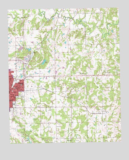
Ardmore East, OK USGS Topographic Map
Click on map above to begin viewing in our Map Viewer.

This topographic map contains these locations and features:
Feature Name Type Latitude Longitude GNIS ID View Map
Ardmore Downtown Executive AirportAirportN34.1506°W97.1211°1102363View Map
Ardmore Fire Department Station 2BuildingN34.1697°W97.1144°2658540View Map
Bass Aero AirportAirportN34.2182°W97.0521°2717023View Map
Caldwell HillPopulated PlaceN34.1873°W97.0164°1090806View Map
Carter 1 DamDamN34.2151°W97.1086°1751342View Map
Carter 1 ReservoirReservoirN34.2151°W97.1086°1751343View Map
Chickasaw LakeReservoirN34.2007°W97.0853°1091275View Map
Chickasaw Lake DamDamN34.2018°W97.0853°1751536View Map
Church of Christ NortheastChurchN34.1745°W97.1097°1778634View Map
Clearview CemeteryCemeteryN34.1881°W97.1070°1095617View Map
Cole CemeteryCemeteryN34.2278°W97.1027°2582495View Map
Concord CemeteryCemeteryN34.1269°W97.0526°2582269View Map
Concord ChurchChurchN34.1265°W97.0517°1091607View Map
Deadman BranchStreamN34.2468°W97.0703°1091970View Map
Dickson Volunteer Fire Department Station 2BuildingN34.1882°W97.0471°2658532View Map
Douglas SchoolSchoolN34.1795°W97.1117°1092167View Map
Dripping SpringsPopulated PlaceN34.1870°W97.0383°1092194View Map
Fraley ParkParkN34.1770°W97.1195°1093007View Map
Lake Murray State ParkBuildingN34.1350°W97.1084°2658718View Map
Mckown LakeReservoirN34.2118°W97.1003°1751345View Map
Mckown Lake DamDamN34.2118°W97.1003°1751344View Map
Metropolitan AME ChurchChurchN34.1743°W97.1170°1778651View Map
Moore PondReservoirN34.2051°W97.0036°1753639View Map
Moore Pond DamDamN34.2051°W97.0036°1753638View Map
Niblack ChapelChurchN34.1401°W97.0728°1095865View Map
Northeast Baptist ChurchChurchN34.1782°W97.1178°1778652View Map
ProvencePopulated PlaceN34.1512°W97.0208°1100766View Map
Provence CemeteryCemeteryN34.1546°W97.0217°1096941View Map
Provence ChurchChurchN34.1540°W97.0386°1096942View Map
Pruitt CemeteryCemeteryN34.1975°W97.0737°1096947View Map
Roberts Airport (historical)AirportN34.1565°W97.0783°1763560View Map
Sand BranchStreamN34.2226°W97.0181°1097723View Map
Sand CreekStreamN34.2401°W97.0614°1097730View Map
Southern Oklahoma Technology CenterSchoolN34.1854°W97.0832°2712828View Map
Springdale ChurchChurchN34.1584°W97.0908°1098449View Map
Springdale SchoolSchoolN34.1587°W97.0795°1098451View Map
Township of WilsonCivilN34.1584°W97.0086°1824725View Map
Trinity Baptist ChurchChurchN34.1845°W97.1228°1778657View Map
Victory Temple Church of GodChurchN34.1712°W97.1225°1778659View Map
Washington SchoolSchoolN34.1765°W97.1183°1099392View Map
West Anadarche CreekStreamN34.1323°W97.1039°1099499View Map
Whittington ParkParkN34.1618°W97.1195°1099746View Map
Will Rogers Elementary SchoolSchoolN34.1880°W97.1245°1099821View Map

Note: Coordinates in the location and feature list above are referenced to NAD83 datum.


Copyright (C) 2008-2025 Ryan Niemi / Sunset Dynamics ... All Rights Reserved