TopoQuest Logo
Do you find TopoQuest useful?
Help keep TopoQuest running and adding new maps/features by donating!
Bitcoin:  19c7KJd3qBynnjoSw5npx9KScwjBe4ifkT
Litecoin:  LXs6TkuXGGXo1vDsWCkWVdjQX94eUKd6ui
Home View Maps Find Maps Find Places Resources & Links


McMillan, Oklahoma Topographic Map

USGS Map Title: McMillan, OK
USGS Map MRC: 34096A8
DRG (GeoTIFF) Download: o34096a8.tif


Neighboring USGS Topographic Map Quads:


  Ardmore East, OK  
34097B1
 

  Mannsville, OK  
34096B8
 

  Ravia, OK  
34096B7
 

  Lake Murray, OK  
34097A1
 

  McMillan, OK  
34096A8
 

  Madill, OK  
34096A7
 

  Marietta East, OK  
33097H1
 

  Lebanon, OK  
33096H8
 

  Shay, OK  
33096H7


Map MRC Location:

N35°
W97°
N35°
W96°
H8 H7 H6 H5 H4 H3 H2 H1
G8 G7 G6 G5 G4 G3 G2 G1
F8 F7 F6 F5 F4 F3 F2 F1
E8 E7 E6 E5 E4 E3 E2 E1
D8 D7 D6 D5 D4 D3 D2 D1
C8 C7 C6 C5 C4 C3 C2 C1
B8 B7 B6 B5 B4 B3 B2 B1
A8 A7 A6 A5 A4 A3 A2 A1
N34°
W97°
N34°
W96°

McMillan, OK USGS 1:24K Topographic Map Preview:
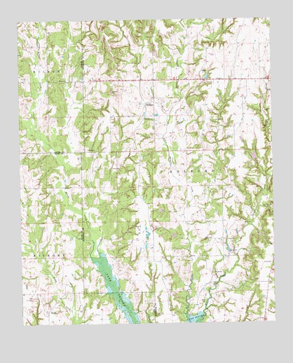
McMillan, OK USGS Topographic Map
Click on map above to begin viewing in our Map Viewer.

This topographic map contains these locations and features:
Feature Name Type Latitude Longitude GNIS ID View Map
EvillePopulated PlaceN34.0051°W96.9872°1100402View Map
Hauana Creek Fire DepartmentBuildingN34.0983°W96.8867°2657489View Map
Hauani CreekStreamN34.0637°W96.8750°1101900View Map
I Hunter Pickens CemeteryCemeteryN34.0383°W96.9402°2709119View Map
Jack McDearman 8 DamDamN34.0234°W96.9270°1754236View Map
Jack McDearman ReservoirReservoirN34.0234°W96.9270°1754237View Map
Jim Conrad DamDamN34.0368°W96.9236°1754234View Map
Jim Conrad ReservoirReservoirN34.0362°W96.9244°1754235View Map
Keel CemeteryCemeteryN34.0330°W96.9069°2709120View Map
McMillanPopulated PlaceN34.0898°W96.9372°1100621View Map
McMillan CemeteryCemeteryN34.0850°W96.9370°1095275View Map
Milford Clement DamDamN34.0051°W96.8786°1754232View Map
Milford Clement ReservoirReservoirN34.0046°W96.8787°1754233View Map
Oknoname 095001 DamDamN34.0284°W96.8970°1753351View Map
Oknoname 095001 ReservoirReservoirN34.0307°W96.8978°1753352View Map
Pickens CemeteryCemeteryN34.0727°W96.9661°2709124View Map
Pickens ChurchChurchN34.0718°W96.9661°1096613View Map
Township of HalfordCivilN34.0626°W96.9086°1824712View Map
TylerPopulated PlaceN34.1037°W96.9097°1100901View Map
Wilson CemeteryCemeteryN34.1001°W96.9807°1099879View Map

Note: Coordinates in the location and feature list above are referenced to NAD83 datum.


Copyright (C) 2008-2025 Ryan Niemi / Sunset Dynamics ... All Rights Reserved