TopoQuest Logo
Do you find TopoQuest useful?
Help keep TopoQuest running and adding new maps/features by donating!
Bitcoin:  19c7KJd3qBynnjoSw5npx9KScwjBe4ifkT
Litecoin:  LXs6TkuXGGXo1vDsWCkWVdjQX94eUKd6ui
Home View Maps Find Maps Find Places Resources & Links


Mannsville, Oklahoma Topographic Map

USGS Map Title: Mannsville, OK
USGS Map MRC: 34096B8
DRG (GeoTIFF) Download: o34096b8.tif


Neighboring USGS Topographic Map Quads:


  Gene Autry, OK  
34097C1
 

  Nebo, OK  
34096C8
 

  Troy, OK  
34096C7
 

  Ardmore East, OK  
34097B1
 

  Mannsville, OK  
34096B8
 

  Ravia, OK  
34096B7
 

  Lake Murray, OK  
34097A1
 

  McMillan, OK  
34096A8
 

  Madill, OK  
34096A7


Map MRC Location:

N35°
W97°
N35°
W96°
H8 H7 H6 H5 H4 H3 H2 H1
G8 G7 G6 G5 G4 G3 G2 G1
F8 F7 F6 F5 F4 F3 F2 F1
E8 E7 E6 E5 E4 E3 E2 E1
D8 D7 D6 D5 D4 D3 D2 D1
C8 C7 C6 C5 C4 C3 C2 C1
B8 B7 B6 B5 B4 B3 B2 B1
A8 A7 A6 A5 A4 A3 A2 A1
N34°
W97°
N34°
W96°

Mannsville, OK USGS 1:24K Topographic Map Preview:
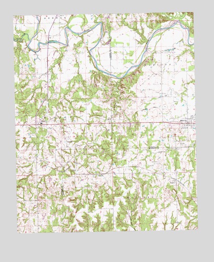
Mannsville, OK USGS Topographic Map
Click on map above to begin viewing in our Map Viewer.

This topographic map contains these locations and features:
Feature Name Type Latitude Longitude GNIS ID View Map
Baum ChurchChurchN34.2498°W96.9672°1089890View Map
Caddo CreekStreamN34.2354°W96.9889°1090798View Map
DicksonPopulated PlaceN34.1873°W96.9845°1092086View Map
Dickson Elementary SchoolSchoolN34.1881°W96.9819°1790547View Map
Dickson High SchoolSchoolN34.1903°W96.9836°1790252View Map
Dickson Middle SchoolSchoolN34.1896°W96.9832°1790546View Map
Dickson Police DepartmentBuildingN34.1867°W96.9981°2757602View Map
Dickson Upper Elementary SchoolSchoolN34.1886°W96.9827°2712934View Map
Dickson Volunteer Fire Department Station 1BuildingN34.1869°W96.9865°2658318View Map
DurwoodPopulated PlaceN34.1768°W96.9647°1100372View Map
Durwood CemeteryCemeteryN34.1566°W96.9429°2709118View Map
Durwood ChurchChurchN34.1573°W96.9433°1092313View Map
Durwood SchoolSchoolN34.1601°W96.9589°1092314View Map
EarlPopulated PlaceN34.2018°W96.8978°1092342View Map
Earl CemeteryCemeteryN34.2330°W96.8840°1092343View Map
Lone Cedar CemeteryCemeteryN34.2497°W96.9293°1094892View Map
MannsvillePopulated PlaceN34.1859°W96.8806°1095119View Map
Mannsville Post OfficePost OfficeN34.1865°W96.8823°1814923View Map
Mannsville Volunteer Fire Department Station 2BuildingN34.1877°W96.8792°2657530View Map
Marvin Poppe 5 DamDamN34.1534°W96.8853°1754242View Map
Marvin Poppe 5 ReservoirReservoirN34.1534°W96.8853°1754243View Map
Nelda CemeteryCemeteryN34.1748°W96.9587°1095784View Map
Oil CreekStreamN34.2454°W96.8847°1096187View Map
Rollins CemeteryCemeteryN34.1645°W96.9014°1097402View Map
SimpsonPopulated PlaceN34.1529°W96.8895°1098061View Map
Thomas CemeteryCemeteryN34.2452°W96.9679°1098846View Map
Town of DicksonCivilN34.1876°W96.9970°2412429View Map
Town of MannsvilleCivilN34.1857°W96.8974°2412945View Map
Wolf CreekStreamN34.2129°W96.9261°1099942View Map

Note: Coordinates in the location and feature list above are referenced to NAD83 datum.


Copyright (C) 2008-2025 Ryan Niemi / Sunset Dynamics ... All Rights Reserved