TopoQuest Logo
Do you find TopoQuest useful?
Help keep TopoQuest running and adding new maps/features by donating!
Bitcoin:  19c7KJd3qBynnjoSw5npx9KScwjBe4ifkT
Litecoin:  LXs6TkuXGGXo1vDsWCkWVdjQX94eUKd6ui
Home View Maps Find Maps Find Places Resources & Links


Gene Autry, Oklahoma Topographic Map

USGS Map Title: Gene Autry, OK
USGS Map MRC: 34097C1
DRG (GeoTIFF) Download: o34097c1.tif


Neighboring USGS Topographic Map Quads:


  Turner Falls, OK  
34097D2
 

  Dougherty, OK  
34097D1
 

  Sulphur South, OK  
34096D8
 

  Springer, OK  
34097C2
 

  Gene Autry, OK  
34097C1
 

  Nebo, OK  
34096C8
 

  Ardmore West, OK  
34097B2
 

  Ardmore East, OK  
34097B1
 

  Mannsville, OK  
34096B8


Map MRC Location:

N35°
W98°
N35°
W97°
H8 H7 H6 H5 H4 H3 H2 H1
G8 G7 G6 G5 G4 G3 G2 G1
F8 F7 F6 F5 F4 F3 F2 F1
E8 E7 E6 E5 E4 E3 E2 E1
D8 D7 D6 D5 D4 D3 D2 D1
C8 C7 C6 C5 C4 C3 C2 C1
B8 B7 B6 B5 B4 B3 B2 B1
A8 A7 A6 A5 A4 A3 A2 A1
N34°
W98°
N34°
W97°

Gene Autry, OK USGS 1:24K Topographic Map Preview:
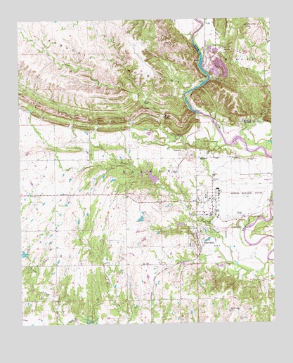
Gene Autry, OK USGS Topographic Map
Click on map above to begin viewing in our Map Viewer.

This topographic map contains these locations and features:
Feature Name Type Latitude Longitude GNIS ID View Map
Abramville CemeteryCemeteryN34.2728°W97.0751°2582499View Map
Academy ChurchChurchN34.3212°W97.0450°1089515View Map
Ardmore Air Force Base (historical)MilitaryN34.3017°W97.0139°2090270View Map
Ardmore Air Park Fire Department Suite 7BuildingN34.2995°W97.0270°2658407View Map
Ardmore Airpark CemeteryCemeteryN34.2912°W97.0313°2582498View Map
Ardmore Army Air Field (historical)MilitaryN34.3017°W97.0139°2090271View Map
Ardmore Industrial AirparkBuildingN34.2972°W97.0337°2711323View Map
Ardmore Municipal AirportAirportN34.2995°W97.0270°1102362View Map
Berwyn CemeteryCemeteryN34.2847°W97.0421°2582267View Map
Big BranchStreamN34.2754°W97.0036°1090093View Map
Big Canyon CemeteryCemeteryN34.3631°W97.0258°1090102View Map
Board Hollow CreekStreamN34.3620°W97.0350°1090316View Map
Bullhead CreekStreamN34.2501°W97.1033°1090693View Map
Caddo Creek Site 28 DamDamN34.3084°W97.0653°1758619View Map
Caddo Creek Site 28 ReservoirReservoirN34.3084°W97.0653°1758620View Map
Caddo Creek Site 29 DamDamN34.3118°W97.0436°1758621View Map
Caddo Creek Site 29 ReservoirReservoirN34.3118°W97.0436°1758622View Map
Calvary CemeteryCemeteryN34.3210°W97.0445°2582270View Map
Cedar FallsFallsN34.3351°W97.0531°1091111View Map
Cool CreekStreamN34.3234°W97.0231°1091630View Map
CrusherPopulated PlaceN34.3506°W97.0295°1100336View Map
Denmark CreekStreamN34.3220°W97.0067°1092041View Map
Farmer HoleLakeN34.3409°W97.0625°1092764View Map
Gene AutryPopulated PlaceN34.2837°W97.0381°1093157View Map
Gene Autry Fire DepartmentBuildingN34.2848°W97.0385°2658567View Map
Henderson CemeteryCemeteryN34.3170°W97.0119°1093662View Map
Mount Pleasant CemeteryCemeteryN34.2518°W97.0186°1095594View Map
Mount Pleasant ChurchChurchN34.2554°W97.0222°1095599View Map
Old Berwyn CemeteryCemeteryN34.2908°W97.0418°2582487View Map
Target CreekStreamN34.3154°W97.0770°1102104View Map
Town of Gene AutryCivilN34.3152°W97.0384°2412674View Map
Township of BerwynCivilN34.3126°W97.0642°1824721View Map
White MoundSummitN34.3723°W97.0078°1099703View Map

Note: Coordinates in the location and feature list above are referenced to NAD83 datum.


Copyright (C) 2008-2024 Ryan Niemi / Sunset Dynamics ... All Rights Reserved