TopoQuest Logo
Do you find TopoQuest useful?
Help keep TopoQuest running and adding new maps/features by donating!
Bitcoin:  19c7KJd3qBynnjoSw5npx9KScwjBe4ifkT
Litecoin:  LXs6TkuXGGXo1vDsWCkWVdjQX94eUKd6ui
Home View Maps Find Maps Find Places Resources & Links


Fairfax, South Carolina Topographic Map

USGS Map Title: Fairfax, SC
USGS Map MRC: 32081H2
DRG (GeoTIFF) Download: o32081h2.tif


Neighboring USGS Topographic Map Quads:


  Allendale, SC  
33081A3
 

  Sycamore, SC  
33081A2
 

  Ehrhardt, SC  
33081A1
 

  Barton, SC  
32081H3
 

  Fairfax, SC  
32081H2
 

  Crocketville, SC  
32081H1
 

  Solomons Crossroads, SC  
32081G3
 

  Gifford, SC  
32081G2
 

  Hampton, SC  
32081G1


Map MRC Location:

N33°
W82°
N33°
W81°
H8 H7 H6 H5 H4 H3 H2 H1
G8 G7 G6 G5 G4 G3 G2 G1
F8 F7 F6 F5 F4 F3 F2 F1
E8 E7 E6 E5 E4 E3 E2 E1
D8 D7 D6 D5 D4 D3 D2 D1
C8 C7 C6 C5 C4 C3 C2 C1
B8 B7 B6 B5 B4 B3 B2 B1
A8 A7 A6 A5 A4 A3 A2 A1
N32°
W82°
N32°
W81°

Fairfax, SC USGS 1:24K Topographic Map Preview:
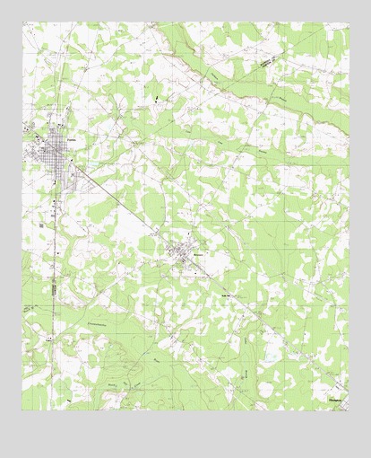
Fairfax, SC USGS Topographic Map
Click on map above to begin viewing in our Map Viewer.

This topographic map contains these locations and features:
Feature Name Type Latitude Longitude GNIS ID View Map
Allendale County HospitalHospitalN32.9655°W81.2479°1247927View Map
Allendale Fire Department Station 200BuildingN32.9631°W81.2345°2368211View Map
Beech BranchStreamN32.9093°W81.2454°1245032View Map
Blood Hill CreekStreamN32.8896°W81.1915°1220806View Map
Brandon CrossingBridgeN32.8935°W81.2032°1232138View Map
BrunsonPopulated PlaceN32.9254°W81.1873°1247030View Map
Brunson Baptist ChurchChurchN32.9240°W81.1884°2490229View Map
Brunson DivisionCivilN32.9516°W81.1554°1938212View Map
Brunson Elementary SchoolSchoolN32.9236°W81.1877°1232141View Map
Brunson Post OfficePost OfficeN32.9260°W81.1889°1252073View Map
Brunson Town HallBuildingN32.9261°W81.1888°2490466View Map
Camp ChristianLocaleN32.9004°W81.1582°1232145View Map
DukesPopulated PlaceN32.8977°W81.2379°1222142View Map
FairfaxPopulated PlaceN32.9590°W81.2365°1247704View Map
Fairfax Elementary SchoolSchoolN32.9509°W81.2307°1233117View Map
Fairfax Police DepartmentBuildingN32.9592°W81.2386°2334883View Map
Fairfax Post OfficePost OfficeN32.9593°W81.2365°1252105View Map
Halls MillPopulated PlaceN32.9099°W81.1657°1231358View Map
HamptonPopulated PlaceN32.8779°W81.1276°1245894View Map
Hampton Fire Department Station 10BuildingN32.9271°W81.1850°2368166View Map
Harrison SawmillLocaleN32.9427°W81.1290°1223064View Map
Jackson Branch ChurchChurchN32.9740°W81.1568°1251708View Map
Jackson Branch SchoolSchoolN32.9740°W81.1554°1223495View Map
Lovetts CrossingBridgeN32.9043°W81.2276°1232184View Map
Macedonia ChurchChurchN32.8768°W81.2095°1246497View Map
Macedonia School (historical)SchoolN32.8760°W81.2101°1232185View Map
Mount Carmel Holiness ChurchChurchN32.9570°W81.1680°2490235View Map
Penn Branch School (historical)SchoolN32.9113°W81.2173°1232197View Map
Pond TownPopulated PlaceN32.9166°W81.1357°1232198View Map
Prince William ChurchChurchN32.9179°W81.1312°1250246View Map
Prince William SchoolSchoolN32.9013°W81.1290°1225674View Map
Prince WIlliam School (historical)SchoolN32.9171°W81.1329°1232200View Map
Rentz Fish Pond D-2600 DamDamN32.8918°W81.1582°1239541View Map
Richardson CrossroadsPopulated PlaceN32.9132°W81.2193°1232201View Map
Rock Hill Church (historical)ChurchN32.9504°W81.1626°1250420View Map
Second Baptist ChurchChurchN32.9323°W81.1978°2490240View Map
Stumpy Pond Church (historical)ChurchN32.9993°W81.1540°1233169View Map
Stumpy Pond School (historical)SchoolN32.9993°W81.1540°1233170View Map
Town of BrunsonCivilN32.9243°W81.1886°2405336View Map
Town of FairfaxCivilN32.9593°W81.2363°2406478View Map
Youngs SchoolSchoolN32.9996°W81.2009°1227738View Map

Note: Coordinates in the location and feature list above are referenced to NAD83 datum.


Copyright (C) 2008-2024 Ryan Niemi / Sunset Dynamics ... All Rights Reserved