TopoQuest Logo
Do you find TopoQuest useful?
Help keep TopoQuest running and adding new maps/features by donating!
Bitcoin:  19c7KJd3qBynnjoSw5npx9KScwjBe4ifkT
Litecoin:  LXs6TkuXGGXo1vDsWCkWVdjQX94eUKd6ui
Home View Maps Find Maps Find Places Resources & Links


El Cajon Mountain, California Topographic Map

USGS Map Title: El Cajon Mountain, CA
USGS Map MRC: 32116H7
DRG (GeoTIFF) Download: o32116h7.tif


Neighboring USGS Topographic Map Quads:


  San Pasqual, CA  
33116A8
 

  Ramona, CA  
33116A7
 

  Santa Ysabel, CA  
33116A6
 

  San Vicente Reservoir, CA  
32116H8
 

  El Cajon Mountain, CA  
32116H7
 

  Tule Springs, CA  
32116H6
 

  El Cajon, CA  
32116G8
 

  Alpine, CA  
32116G7
 

  Viejas Mountain, CA  
32116G6


Map MRC Location:

N33°
W117°
N33°
W116°
H8 H7 H6 H5 H4 H3 H2 H1
G8 G7 G6 G5 G4 G3 G2 G1
F8 F7 F6 F5 F4 F3 F2 F1
E8 E7 E6 E5 E4 E3 E2 E1
D8 D7 D6 D5 D4 D3 D2 D1
C8 C7 C6 C5 C4 C3 C2 C1
B8 B7 B6 B5 B4 B3 B2 B1
A8 A7 A6 A5 A4 A3 A2 A1
N32°
W117°
N32°
W116°

El Cajon Mountain, CA USGS 1:24K Topographic Map Preview:
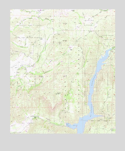
El Cajon Mountain, CA USGS Topographic Map
Click on map above to begin viewing in our Map Viewer.

This topographic map contains these locations and features:
Feature Name Type Latitude Longitude GNIS ID View Map
Anderson ValleyFlatN32.8790°W116.7537°269530View Map
BaronaPopulated PlaceN32.9359°W116.8681°1656430View Map
Barona Fire Protection District Station 27BuildingN32.9407°W116.8544°2665290View Map
Barona Indian ReservationReserveN32.9517°W116.8450°269684View Map
Barona MesaSummitN32.9895°W116.7842°1656431View Map
Barona ReservationCivilN32.9522°W116.8471°255962View Map
Barona Tribal EnforcementBuildingN32.9326°W116.8705°2756227View Map
Caņada De San Vicente Y Mesa Del Padre BaronaCivilN32.9773°W116.8575°270268View Map
Cape Horn TunnelTunnelN32.8875°W116.8445°1666234View Map
Capitan Grande ReservationCivilN32.9140°W116.7553°240225View Map
Chocolate CreekStreamN32.8820°W116.7934°1666229View Map
Conejos CreekStreamN32.8926°W116.7653°270579View Map
Daly CreekStreamN32.9623°W116.8589°270748View Map
Daly MineMineN32.9725°W116.8531°270749View Map
El Cajon MountainSummitN32.9148°W116.8197°271024View Map
El Cajon Mountain Truck TrailTrailN32.9400°W116.7920°271025View Map
El Capitan (historical)Populated PlaceN32.9348°W116.7736°1666237View Map
El Capitan 8-007 DamDamN32.8834°W116.8109°1663335View Map
El Capitan DamDamN32.8839°W116.8092°271027View Map
El Capitan LakeReservoirN32.8825°W116.7993°271028View Map
El Capitan Truck TrailTrailN32.9739°W116.7839°271029View Map
El Monte County Park Picnic SiteLocaleN32.8919°W116.8468°2548699View Map
El Monte ParkLocaleN32.8912°W116.8459°271034View Map
Featherstone CanyonValleyN32.9378°W116.8528°271112View Map
Featherstone RanchLocaleN32.9328°W116.8364°271113View Map
Four CornersPopulated PlaceN32.9778°W116.7772°271187View Map
Gower Truck TrailTrailN32.9898°W116.7681°271381View Map
Grable RanchLocaleN32.9595°W116.8045°271383View Map
Indian HeadSummitN32.9850°W116.8109°271715View Map
Indian Head SpringSpringN32.9820°W116.8170°1702016View Map
Isham CreekStreamN32.9581°W116.7575°271740View Map
Klondike CreekStreamN32.9931°W116.8467°271916View Map
Lakeside County ParkParkN32.9212°W116.8686°1869189View Map
Mykrantz RanchLocaleN32.9995°W116.8011°272615View Map
Mykrantz Truck TrailTrailN32.9867°W116.7906°272616View Map
Poole RanchLocaleN32.9912°W116.8536°273075View Map
Rock MountainSummitN32.9323°W116.8111°273313View Map
San Vicente MountainSummitN32.9684°W116.8114°273517View Map
San Vicente ValleyValleyN32.9934°W116.8467°273518View Map
Sand CreekStreamN32.9462°W116.7617°273528View Map
SilverdomeSummitN32.9150°W116.8642°251993View Map
Skunk SpringSpringN32.9705°W116.8402°273736View Map
Windmill FlatFlatN32.9884°W116.8250°274548View Map
Wright CanyonValleyN32.9506°W116.8403°274576View Map

Note: Coordinates in the location and feature list above are referenced to NAD83 datum.


Copyright (C) 2008-2025 Ryan Niemi / Sunset Dynamics ... All Rights Reserved